Report on Karthala (Comoros) — January 2006

Bulletin of the Global Volcanism Network, vol. 31, no. 1 (January 2006)
Managing Editor: Richard Wunderman.
Karthala (Comoros) Looking at the 2005 eruption's precursors, deposits, and human impact
Please cite this report as:
Global Volcanism Program, 2006. Report on Karthala (Comoros) (Wunderman, R., ed.). Bulletin of the Global Volcanism Network, 31:1. Smithsonian Institution. https://doi.org/10.5479/si.GVP.BGVN200601-233010
Karthala
Comoros
11.75°S, 43.38°E; summit elev. 2361 m
All times are local (unless otherwise noted)
After the 11 July 1991 phreatic eruption, 14 years of quiescence at Karthala was disrupted in 2005 by two strong explosive events. These events, occurring on 16 April 2005 (BGVN 30:04) and 24 November 2005 (BGVN 30:11), resulted in deposits of fine ash scattered over a large part of the island. This report presents some further observations and analyses of the November event by scientists from the Comoros and Reunion.
Seismic precursors. The seismicity on figure 16 delineates four periods during 2005: (1) From the beginning of the year until the 16 April explosive event, an interval characterized by significant seismicity. (2) From the 16 April event until just prior to the 25-26 August seismic crisis, an interval with relatively low seismicity (only 102 events recorded in 116 days). (3) An interval from 26 August to 23 November that began during the 25-26 August seismic crisis when 190 events occurred. Moderate seismicity following the seismic crisis ramped up after 27 October until the 24 November eruption. This period was characterized by a total of 1,063 seismic events, an average of 12 earthquakes per day. (4) From the 24 November eruption until the end of the year, an interval of relatively low seismicity similar to the second period. The 24 November earthquake swarm began at 1902, dropped significantly at 1950, and restarted at 2021 with sustained tremor.
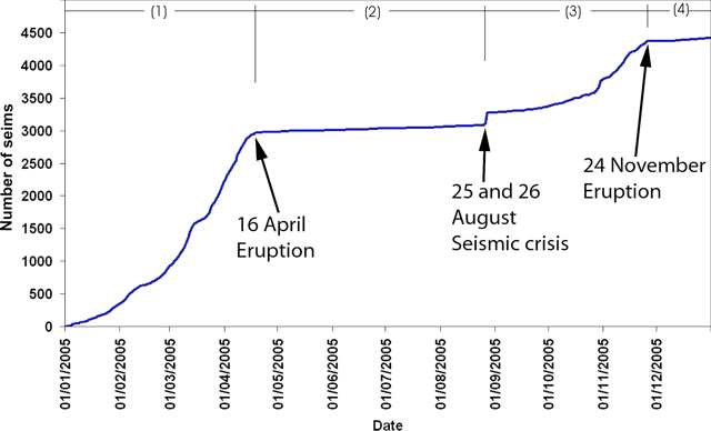 |
Figure 16. Cumulative distribution of earthquakes registered at Karthala during the year 2005. Courtesy of KVO. |
The investigators noted that the seismic crisis of 25-26 August 2005 marked the beginning of the new eruptive cycle. It preceded the November 2005 eruption, but was much more subdued than the build up before the eruptions in April 2005 and July 1991 (BGVN 16:06 and 16:08). Earthquakes were located by KVO using Sismalp (the French Alps Seismic Network). Uniquely, for the November 2005 seismic crisis, the hypocenters were 500-1,000 m shallower than those of April 2005. This could be attributed to shallower magma storage for the last eruption.
Activity during 24 November-5 December 2005. The beginning of the 24 November eruption was visible from Moroni (the capital city of the Comoro Islands) with lightning, rumblings, and a large dark plume at the summit. Ash first fell on the E coast of the island around 2300 on 24 November and the tremor intensity significantly dropped. On the W part of the island, ash started to fall on 25 November at 0500 with very strong intensity. Evacuation became very difficult, schools remained closed, and some people used masks to breathe. Ashfall was so intense that the authorities required the inhabitants to remain in their homes. The United Nations Office for the Coordination of Humanitarian Affairs (OCHA) reported that, according to the local authorities, ~ 2,000 people fled from their villages in the region of Bambao in the central part of the island, and sought refuge in less exposed areas, such as Mitsamiouli, Mboudé, and Oichili.
At 0700 on 25 November the sky was darkened by ash (figures 17 and 18). Part of the population fled towards the N of the island. It was only around 0900 that the sky partially cleared; however, ash continued to fall with decreasing intensity during the day. Ash deposits covered three-quarters of the island. The international airport located in the N part of the island remained free of ash deposits. The Toulouse Volcanic Ash Advisory Center issued an advisory to limit risks for air traffic; however, the eruption did not halt airport operations. Satellite imagery on 25 November revealed an ash cloud reaching ~ 11.6 km altitude.
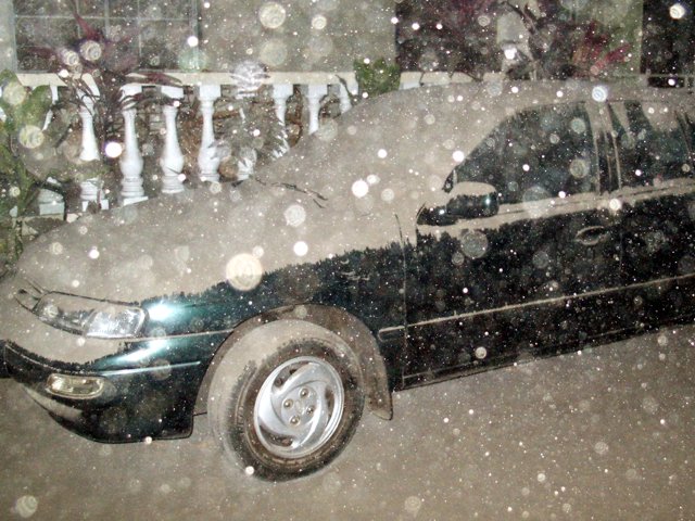 |
Figure 17. An ash plume from Karthala at 1000 on 25 November 2005 led to ash-draped surfaces and heavily filtered sunlight in the capital, Moroni (population variously estimated at 20,000-63,000 residents, located 13 km NW of the summit). Ashfall was very heavy until 1200, then decreased throughout the rest of the day. Courtesy of Hamid Soulé, KVO. |
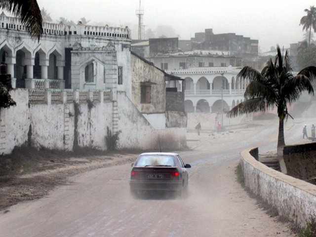 |
Figure 18. Downtown Moroni as it appeared at 1000 on 25 November 2005 after the eruption of Karthala. Courtesy of Dominique Meyer-Bisch, Embassy of France in Comoros Islands. |
During 25 November, about 30 seismic events were recorded by KVO, causing concern about the possibility of a crack or fissure opening on Karthala's flank, as occurred in April 1977 (SEAN 02:03). During the night, red glow at the summit was clearly visible from the coast.
On 26 November, a field excursion found a lava lake in the Chahalé crater (figure 19). Prior to the eruption that crater's floor had been covered by a water lake some tens of meters deep. In contrast to the crusted-over lava lake of April 2005 (BGVN 30:04), in November it was almost entirely liquid, with a very large fountain in its center. By 30 November the lava lake had solidified over ~ 80 % of its surface (figure 20). On 5 December it was almost entirely solid, with only two small spatter cones active (figure 21).
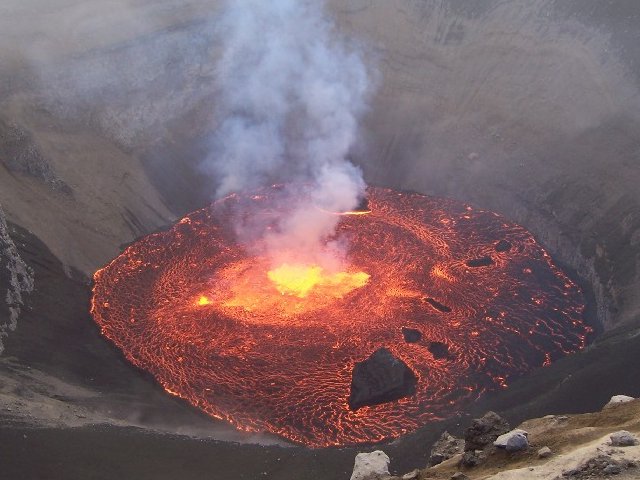 |
Figure 19. On 26 November 2005 investigators ascended Karthala and observed a molten-surfaced lava lake inside Chahalé crater. The lake was about 60-80 m in diameter. Many parts of the lake had a molten surface covered by a chilled skin, although some large blocks of cooler material also lay scattered in the lake. This picture was taken looking down from the crater's N edge. Courtesy of Christophe Roche, French school teacher in Moroni. |
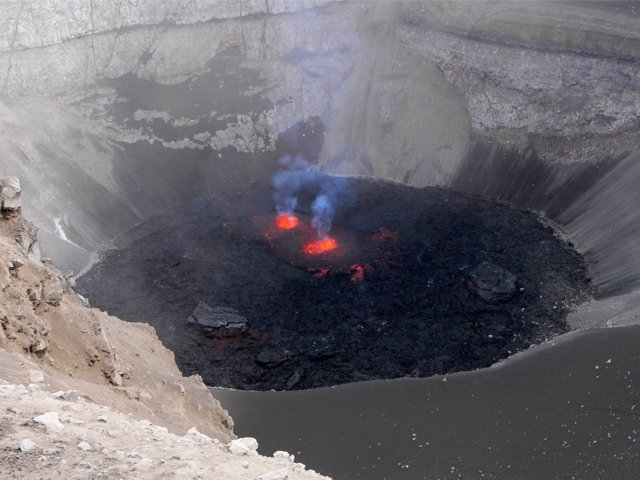 |
Figure 20. On 30 November 2005 a field excursion allowed investigators to observe the ongoing solidification of the lava lake inside Karthala's Chahalé crater. The only incandescence plainly visible appears in the lake's central area. This picture was taken looking from the crater's NW edge. Courtesy of François Sauvestre, KVO. |
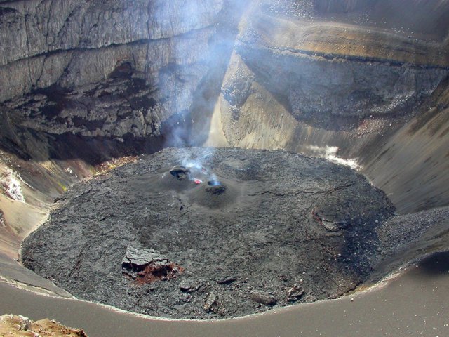 |
Figure 21. A Karthala excursion on 5 December 2005 allowed scientists to observe an almost entirely solidified lava lake. Two small (5-m high) spatter cones had developed over the area previously hosting the most intense incandescence, and some small zones adjacent to them still remained incandescent. The cones stopped being active on 8 December. This picture was taken looking from the NW edge of the crater. Courtesy of François Martel-Asselin. |
Eruptive products. The landscape at the summit illustrated the style and intensity of the eruption. Measurements of ash deposit thickness were difficult to make. Along the coast ash deposits were between a few millimeters and a few tens of millimeters thick. On the W side of the caldera, ~ 1.5 km from the crater, 70 cm of ash deposits were measured at the same location where 40 cm of ash had fallen in April 2005, an increase of 30 cm in thickness. Closer to the crater, the thicknesses were not measured because they were greater than 1.5 m.
Field work revealed that on the edge of the caldera, ballistic blocks had fallen from the phreatomagmatic phase at the beginning of the eruption. Closer to the central crater the density of volcanic debris increased strongly. In an area covered by several tens of centimeters of ash, blocks impacted the ground leaving an amazing number of craters on the surface (figure 22). Distinctive tephra deposits, presumably related to lava fountains were identifiable everywhere around the central crater (figure 23). These juvenile deposits spread 500 m N from the central crater, whereas they extended only 100 m or less to the S. Products of this magmatic phase were clearly erupted or carried by wind to the N, and they must have ascended higher than 300 m, the depth of the Chahalé pit crater. On 8 December 2005 at about 1000 (15 days after the eruption), both seismic and explosive activity stopped.
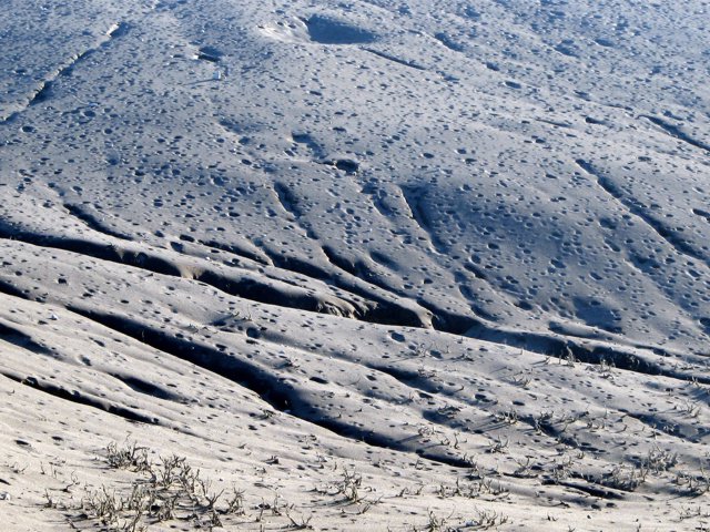 |
Figure 22. Bomb impact craters on the N and E sides of Karthala's summit convey a surprising intensity of ballistic bombardment. This picture was taken from the summit (E side of Chahalé crater) looking to the N. Courtesy of Philippe Crozet. |
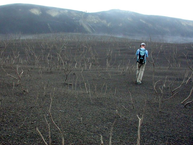 |
Figure 23. An area around Karthala's summit was covered by tephra deposits. The approximately 2-m high vegetation that remained after the eruption of April 2005 was reduced to about 1-m high in this later, though undated, photo. A 1-m-thick layer of tephra was measured 700 m from the eruptive center. This picture was taken on the W part of the caldera looking NW. Courtesy of François Martel-Asselin. |
Human impact. This eruption was more explosive and longer than the two preceding eruptions in spite of weaker seismicity, and a significant quantity of ash fell in water cisterns. According to OCHA, there were about 118,000 people living in 75 villages that were affected by the cistern contamination. Wind continued to raise large quantities of ash that again fell on the dwellings and into cisterns. In contrast to the April 2005 eruption, no coastal residents reported smelling sulfurous odors. After the end of the eruption, few long period earthquakes were recorded.
Geological Summary. The southernmost and largest of the two shield volcanoes forming Grand Comore Island (also known as Ngazidja Island), Karthala contains a 3 x 4 km summit caldera generated by repeated collapse. Elongated rift zones extend to the NNW and SE from the summit of the Hawaiian-style basaltic shield, which has an asymmetrical profile that is steeper to the S. The lower SE rift zone forms the Massif du Badjini, a peninsula at the SE tip of the island. Historical eruptions have modified the morphology of the compound, irregular summit caldera. More than twenty eruptions have been recorded since the 19th century from the summit caldera and vents on the N and S flanks. Many lava flows have reached the sea on both sides of the island. An 1860 lava flow from the summit caldera traveled ~13 km to the NW, reaching the W coast to the N of the capital city of Moroni.
Information Contacts: Nicolas Villeneuve, Centre de Recherches d'études Géographiques de l'Université de La Réunion (CREGUR), Université de La Réunion, BP 7151, 15 Avenue, René Cassin, 97715 Saint-Denis, Réunion, France; Anthony Finizola and Patrick Bachèlery, Laboratoire des Sciences de la Terre de l'Universite de la Reunion (LSTUR), Université de La Réunion, BP 7151, 15 Avenue, René Cassin, 97715 Saint-Denis, Réunion, France; Francois Sauvestre and Hamid Soulé, Centre National de Documentation et de Recherche Scientifique (CNDRS), Place France, BP 169, Moroni, République Fédérale Islamique des Comores (URL: http://volcano.ipgp.jussieu.fr/karthala/stationkar.html); Karthala Volcano Observatory (KVO), Centre National de Documentation et de la Recherche Scientifique des Comores, BP 169, Moroni, République Fédérale Islamique des Comores.