Report on Ambae (Vanuatu) — January 2006

Bulletin of the Global Volcanism Network, vol. 31, no. 1 (January 2006)
Managing Editor: Richard Wunderman.
Ambae (Vanuatu) Crater-lake photos and satellite temperatures data show ongoing activity
Please cite this report as:
Global Volcanism Program, 2006. Report on Ambae (Vanuatu) (Wunderman, R., ed.). Bulletin of the Global Volcanism Network, 31:1. Smithsonian Institution. https://doi.org/10.5479/si.GVP.BGVN200601-257030
Ambae
Vanuatu
15.389°S, 167.835°E; summit elev. 1496 m
All times are local (unless otherwise noted)
As previously reported, a new eruption at Aoba began 27 November 2005 in one of the crater lakes (Lake Voui). The eruption formed a cinder cone in the lake (figures 23 and 24) that contained a crater with a small hot lake (BGVN 30:11 and 30:12).
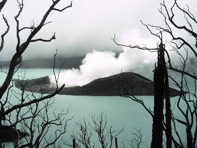 |
Figure 23. A view of Aoba's Lake Voui on 18 January 2006, showing the new island and its steaming internal lake. Courtesy Alain Bernard. |
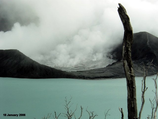 |
Figure 24. Steam rising from the lake on the island in the middle of Aoba's Lake Voui, 18 January 2006. Courtesy Alain Bernard. |
On 31 January a high, dark ash plume caused ashfall in the S part of the island. Small eruptions continued in February.
Alain Bernard recently processed a 26 January 2006 nighttime ASTER (Advanced Spaceborne Thermal Emission and Reflection Radiometer) image. Figure 25 shows the ASTER product called AST_04 (TIR?thermal infrared radiometer, 8.12-11.65 ?m wavelengths?band 10) unprocessed image of Aoba with Lakes Voui and Lakua. The TIR bands, with a spatial resolution of 90 m, give the ability to detect small thermal anomalies (a few degrees C), perform thermal mapping, and monitor temporal variations in the lake surface temperature. As shown in figure 26, Lake Voui's temperature in early January 2006 dropped by ~ 10°C to a mean of 25.4°C (down from 35.7°C one month earlier). Temperature differences between Voui and Lakua dropped to 4.3°C, reaching almost to the background levels observed in July 2005 (see plot "Temperature data from Lake Voui at Aoba, October 1998-December 2005 . . ."; BGVN 30:11). There is still a strong thermal anomaly of 46.1°C inside the new island (figure 13).
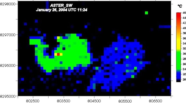 |
Figure 25. A thermal image of Aoba's lakes Voui and Manaro Lakua (to the W and E, respectively) for 26 January 2006 at 1124 UTC (2224 local). The image results from the ASTER On-Demand L2 Brightness Temperature at the Sensor. This AST_04 product is the brightness temperature data as recorded by the satellite, not the temperature of the target at the ground level. To retrieve the actual surface temperature, one needs to correct for atmospheric effects (absorption of water vapor, etc.) that significantly alter the spectral radiance during the travel from the ground to the satellite. A new method for this correction, developed by Alain Bernard and called AST_SW (SW stands for "split window"), is explained on his ("multispectral") website. Courtesy of Alain Bernard. |
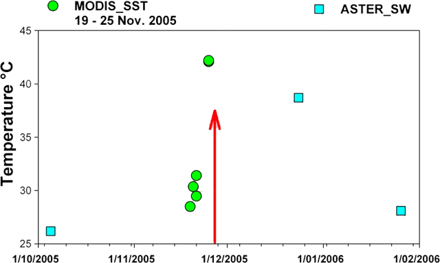 |
Figure 26. A plot of computed temperatures from 1 October 2005 to 1 February 2006 for Aoba's Lake Voui. The two different symbols distinguish processed MODIS and ASTER thermal data. A similar plot for an earlier period appeared in BGVN 30:11. Courtesy of Alain Bernard. |
As of 11 February 2006 at 1011 hours (10 February 2006 at 2311 UTC), Alain Bernard reported that Lakes Voui and Lakua temperatures were, respectively, 27.2°C and 23.2°C (delta T = 4°C). The maximum temperature for the mud pool was ~ 57°C.
Geological Summary. The island of Ambae, also known as Aoba, is a massive 2,500 km3 basaltic shield that is the most voluminous volcano of the New Hebrides archipelago. A pronounced NE-SW-trending rift zone with numerous scoria cones gives the 16 x 38 km island an elongated form. A broad pyroclastic cone containing three crater lakes (Manaro Ngoru, Voui, and Manaro Lakua) is located at the summit within the youngest of at least two nested calderas, the largest of which is 6 km in diameter. That large central edifice is also called Manaro Voui or Lombenben volcano. Post-caldera explosive eruptions formed the summit craters about 360 years ago. A tuff cone was constructed within Lake Voui (or Vui) about 60 years later. The latest known flank eruption, about 300 years ago, destroyed the population of the Nduindui area near the western coast.
Information Contacts: Alain Bernard, IAVCEI Commission on Volcanic Lakes, Université Libre de Bruxelles (ULB), CP160/02, avenue F.D. Roosevelt 50, Brussels, Belgium (URL: http://www.ulb.ac.be/sciences/cvl/aoba/Ambae1.html, http://www.ulb.ac.be/sciences/cvl/multispectral/multispectral2.htm); Esline Garaebiti, Department of Geology, Mines, and Water Resources (DGMWR), Port-Vila, Vanuatu.