Report on Santa Ana (El Salvador) — January 2006

Bulletin of the Global Volcanism Network, vol. 31, no. 1 (January 2006)
Managing Editor: Richard Wunderman.
Santa Ana (El Salvador) Post-eruption lahars but seismicity and SO2 fluxes both often low
Please cite this report as:
Global Volcanism Program, 2006. Report on Santa Ana (El Salvador) (Wunderman, R., ed.). Bulletin of the Global Volcanism Network, 31:1. Smithsonian Institution. https://doi.org/10.5479/si.GVP.BGVN200601-343020
Santa Ana
El Salvador
13.853°N, 89.63°W; summit elev. 2381 m
All times are local (unless otherwise noted)
Previous comments regarding terminal phases of the 1 October 2005 eruption (BGVN 30:09) included: . "Following the eruption of 1 October, small explosions, degassing, and low-to-moderate seismicity occurred at Santa Ana during 5-11 October . . .. During an aerial inspection of the volcano on 11 October, no changes were observed at the crater."
Carlos Pullinger (Servicio Nacional de Estudios Territoriales, SNET) later noted that "The 1 October eruption only lasted about 1 hour. After that we had some small activity, probably associated [with] degassing on Sunday evening [2 October] and at about the same time the continuous rains produced the first of a series of lahars that affected the communities close to the shore of Coatepeque lake. During the rest of the week it was very difficult to know what was going on because of continuous rains and cloudy conditions."
Pullinger further noted that some eye witnesses said that they had observed a column on 2 October. SNET registered strong and continuous tremor during approximately 1900-2400 (local time) on 2 October. Much of this activity coincided with rain-induced lahars. Over 300 mm of rain fell on the volcano that day. Using both witness reports and seismicity, SNET inferred that on 2 October the volcano possibly generated strong degassing or even geyser-type activity. However, there was no confirmation of ashfall deposits from these or other post-1 October events.The same type of seismicity continued intermittently until 5 October, but with much less intensity than on 2 October. SNET could not tell if there was any volcanic activity related to these events, or if it was mainly lahars. After the 5th continuous tremor was not recorded.
Post-eruption behavior. SNET reported that, in general, following Santa Ana's 1 October 2005 eruption, seismicity was relatively stable and there were generally low-level gas emissions (figure 4).
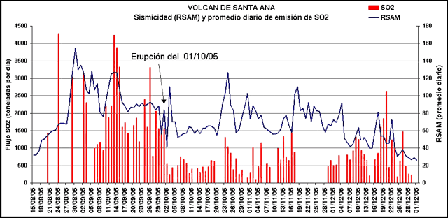 |
Figure 4. A graph showing Santa Ana's SO2 flux (vertical bars) and average daily seismic amplitude (RSAM, solid line) during 15 August-31 December 2005. The eruption of 1 October 2005 is indicated with an arrow. Courtesy of SNET. |
Storms on 12 October 2005 caused lahars that traveled E towards Lake Coatepeque (see ASTER image of the region in BGVN 30:09). On 22 October, a lahar was reactivated in the Potrero Arriba area, NE of the volcano. During 22-25 October, the volcano was subjected to increased tremor and a slight increase in seismicity associated with gas emissions. On 28 October volcanic activity appeared to increase slightly and sulfur-dioxide emission rates during 28 and 29 October averaged 257 metric tons per day. The Alert Level within a 5-km radius around the volcano's central crater was at Red, the highest level.
During the month of November 2005 seismicity, volcanic activity, and gas emissions all remained for the most part at relatively low levels. There were slight increases on 13, 17, and 26 November; but the 17 November increase was attributed to noise from strong winds. On 26 November only slight changes were noted in the color of the lagoon in the crater's interior, but gas emissions rose to ~ 300 m above the volcano. Small earthquakes occurred during November 2005, inferred to be associated with the fracturing of rocks and gas pulses. Sulfur-dioxide emissions were low during the first part of November, with 100 to 200 metric tons recorded daily, and during the latter part of November, with between 100 and ~ 1,500 metric tons recorded daily.
During December 2005, seismicity was above background levels. Observations of Santa Ana's crater on 28 December revealed that there were continuous emissions of steam and gas from the lagoon and fumaroles located within the crater (figure 5). Gas rose 200-500 m above the crater and drifted SW (figure 6). Small earthquakes occurred, but gas emissions rose to over ~ 2,500 tons per day (figure 4). The Alert Level remained at Red, the highest level, within a 5-km radius around the volcano's summit crater.
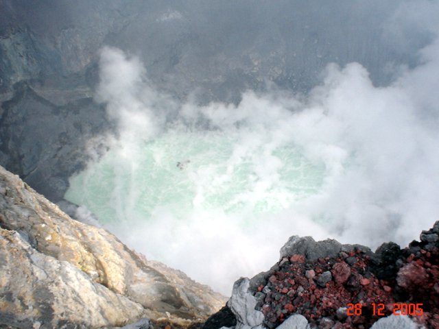 |
Figure 5. A photo taken from the crater rim at Santa Ana showing steam and gas emissions from both the lagoon and fumaroles located within the crater. Courtesy of SNET. |
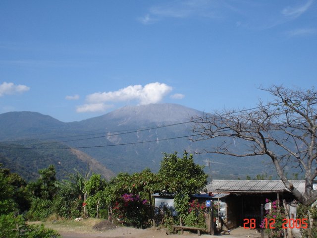 |
Figure 6. A photo of Santa Ana showing the 28 December 2005 gas emission that rose 200-500 m above the crater rim. Courtesy of SNET. |
From 30 December 2005 to early January 2006, seismic and steam emissions were moderate at Santa Ana. Seismicity was slightly above normal levels with small earthquakes occurring, which were interpreted as being associated with gas pulses. Low-level emissions of steam and gas from the lagoon and fumaroles within the crater remained the same as in December 2005. Gas rose 200-500 m above the crater and drifted SW. The sulfur-dioxide flux ranged between 180 and 1,476 metric tons per day. The Alert Level remained at Red, the highest level, within a 5-km radius around the volcano's summit crater.
Background. Santa Ana, El Salvador's highest volcano, is a massive, 2,381-m-high andesitic-to-basaltic stratovolcano that rises immediately W of Coatepeque caldera. Collapse of the volcano during the late Pleistocene produced a voluminous debris avalanche that swept into the Pacific Ocean, forming the Acajutla Peninsula. Reconstruction of the volcano subsequently filled most of the collapse scarp. The broad summit of the volcano is cut by several crescentic craters, and a series of parasitic vents and cones have formed along a 20-km-long fissure system that extends from near the town of Chalchuapa NNW of the volcano to the San Marcelino and Cerro la Olla cinder cones on the SE flank. Historical activity, largely consisting of small-to-moderate explosive eruptions from both summit and flank vents, has been documented since the 16th century. The San Marcelino cinder cone on the SE flank produced a lava flow in 1722 that traveled 13 km to the E.
Geological Summary. Santa Ana (also known as Ilamatepec), is a massive, dominantly andesitic-to-trachyandesitic stratovolcano in El Salvador immediately W of Coatepeque Caldera. Collapse during the late Pleistocene produced a voluminous debris avalanche that swept into the Pacific Ocean, forming the Acajutla Peninsula. Reconstruction of the volcano subsequently filled most of the collapse scarp. The broad summit is cut by several crescentic craters, and a series of vents and cones have formed along a 20-km-long fissure system that extends from near the town of Chalchuapa NNW of the volcano to the San Marcelino and Cerro la Olla cinder cones on the SE flank. Small to moderate explosive eruptions from both summit and flank vents have been documented since the 16th century. The San Marcelino cinder cone on the SE flank produced a lava flow in 1722 that traveled 13 km E.
Information Contacts: Servicio Nacional de Estudios Territoriales (SNET), Alameda Roosevelt y 55 Avenida Norte, Edificio Torre El Salvador, Quinta Planta, San Salvador, El Salvador (URL: http://www.snet.gob.sv/)