Report on Yellowstone (United States) — February 2006
Bulletin of the Global Volcanism Network, vol. 31, no. 2 (February 2006)
Managing Editor: Richard Wunderman.
Yellowstone (United States) Low seismicity; ongoing ground-surface deformation
Please cite this report as:
Global Volcanism Program, 2006. Report on Yellowstone (United States) (Wunderman, R., ed.). Bulletin of the Global Volcanism Network, 31:2. Smithsonian Institution. https://doi.org/10.5479/si.GVP.BGVN200602-325010
Yellowstone
United States
44.43°N, 110.67°W; summit elev. 2805 m
All times are local (unless otherwise noted)
According to the Yellowstone Volcano Observatory (YVO), during February 2006 there was relatively low seismicity, with 82 reported earthquakes in the region. The largest of these was on 25 February, M 3.1, located near the N caldera rim (~ 10 km SSW of Canyon Junction). None of these earthquakes were reported as felt. Our previous report discussed elevated temperatures of the ground and increased hydrothermal effects at Norris hot springs in 2003 (BGVN 28:07). Norris also represents a frequent epicentral area for earthquakes inside the caldera. In 2002, for example, there were more than 2,350 earthquakes detected at Yellowstone, including over 500 triggered by the November 2002, M 7.9 Denali earthquake. Seismicity during April 2005-April 2006 was comparatively low. Figure 8 plots quarterly earthquakes (≥ M 1.5) during 1974-2004 on a histogram. Figure 9 depicts earthquake swarms during 1985, 1995, and 2004.
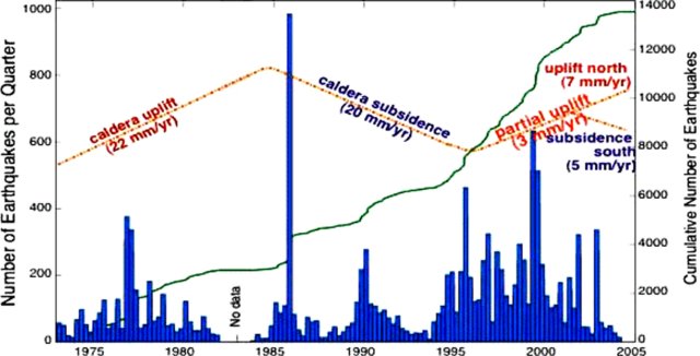 |
Figure 8. A plot of recorded earthquakes (≥ M 1.5) at Yellowstone from 1974 through 2004 (bars, left-hand scale: each bar represents the sum of the earthquakes of stated size per quarter (~ 90 days)). The curving solid line shows the cumulative number of earthquakes for the thirty-year period (right-hand scale). Estimates of mean caldera uplift and subsidence are shown as a dashed-and-dotted line with no scale. Note that this figure stopped in 2004 and does not depict some of the stronger deformation seen in radar and later GPS data (discussed below). Courtesy of YVO (after a figure by Waite and Smith, 2002). |
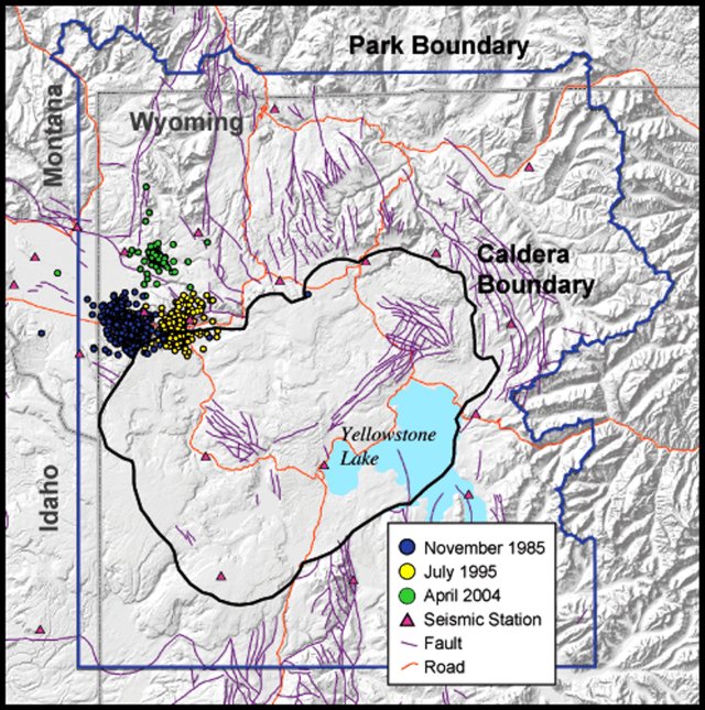 |
Figure 9. A map of Yellowstone caldera and National Park with circles indicating located earthquakes (≥ M 1.5) from the swarm of 1985 (westerly cluster), 1995 (easterly cluster with substantial events inside the caldera), and 2004 (smaller cluster to the N of the other two). Courtesy of YVO. |
Satellite radar created an interferogram of the caldera region (basically, a depiction of the vertical offset determined by satellite radar during 1996-2000). The interferogram portrayed vertical displacement as a large bull's-eye shape (figure 10), and indicated 12.5 cm of uplift centered in the northern portion of the caldera ~ 25 km NW of Yellowstone Lake.
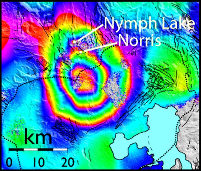 |
Figure 10. A radar interferogram of the Yellowstone caldera region (after Wicks and others, 1998; 2006). This image of vertical ground deformation was created using data from several satellite passes during 1996 through 2000. The image shows 12.5 cm of uplift centered within the northern end of Yellowstone caldera (black dotted line), about 10 km S of Norris hot springs. Each full spectrum of color (from red to purple) represents ~ 28 mm of uplift. The area of uplift is approximately 35 km x 40 km in size. Courtesy of YVO-USGS. |
In response to increased heat and steam emissions in parts of Norris geyser basin, a temporary, five-station GPS network was installed in that area in 2003. The network was installed by a UNAVCO engineer, University of Utah students and faculty, and National Park Service scientists as part of a monitoring effort by YVO. Permanent station NRWY currently resides there (figure 11).
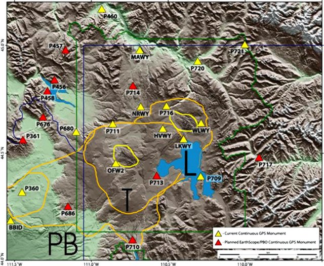 |
Figure 11. GPS stations at Yellowstone caldera, including those both existing (light triangles) and planned (dark triangles). The irregular loops near stations OFW2 and WLWY outline the two active resurgent domes within the 0.64 million-year-old Yellowstone caldera (the Mallard Lake dome and the Sour Creek dome, to the W and E, respectively). The figure also includes Yellowstone caldera topographic margins (T), Yellowstone Lake (L), the National Park boundary (PB), and some state boundaries. Courtesy of YVO-USGS. |
Movement near the N end of Yellowstone Lake was measured by GPS at station LKWY during 1997 to late 2005 (figure 12). The N-S movement (top panel) shown in the past year consisted of displacement of 10-15 mm southward. This N-S movement was somewhat stronger and more protracted than in the earlier parts of the GPS data. The E-W movement (middle panel) was comparatively steady and unbroken over the past 6 years or more, directed westward. Over the past 9 years, the overall E-W motion was ~ 15 mm westward. The vertical motion (lower panel) was negative (subsidence) during 1997 to mid-2004. After that, station LKWY moved sharply upward, rising ~ 80 mm in the last year and a half. Caldera systems frequently undergo ground displacements similar to those observed at Yellowstone without progressing to eruptive activity.
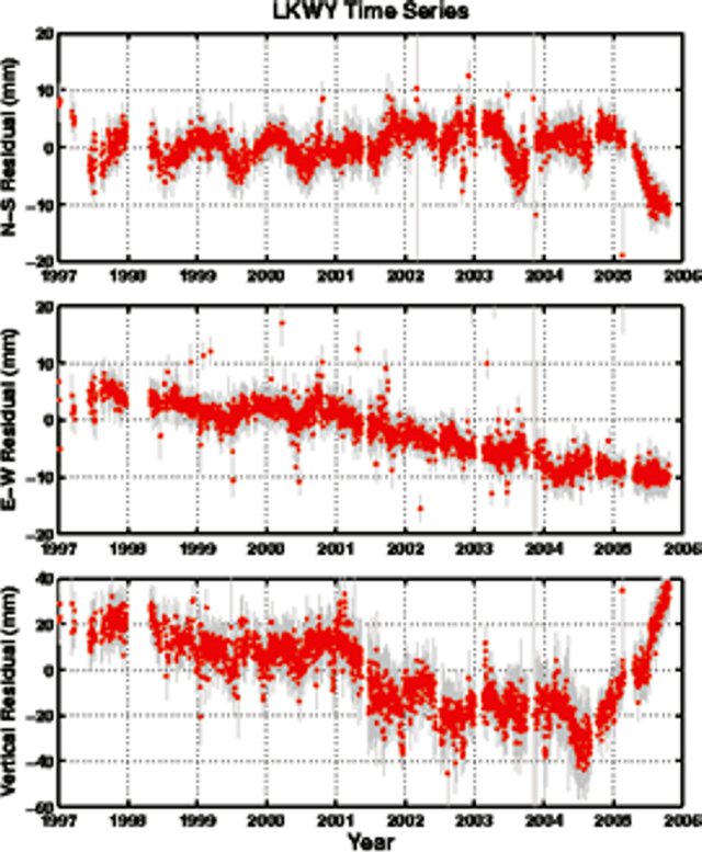 |
Figure 12. Relative movement of GPS station LKWY (located in the central part of the caldera, at the N end of Yellowstone Lake) recorded during 1997 to late 2005. The top panel shows N-S movement, the middle, E-W movement, and the bottom, vertical movement. During 2001-2004 station LKSY moved downward (subsided) on the order of 20 mm. After mid-2004, LKWY moved upward ~ 80 mm. Courtesy of YVO-USGS. |
Much of the history of older calderas that preceded Yellowstone are buried in the subsurface to the W, and a drilling proposal for that region is under development. "Hotspot," the Snake River Scientific Drilling Project, announced an inter-disciplinary workshop with that goal, to be held 18-21 May 2006 and focused on issues central to a new intermediate-depth drilling program in the Snake River Plain of S Idaho, USA. That region provides a record of inferred mantle plume volcanism in an intra-continental setting. Because it is young and tectonically undisturbed, the complete record of volcanic activity can be sampled only by drilling. The preliminary plan was to drill and core 4-6 holes along the axis of the E and W Snake River Plain.
References. Wicks, C., Thatcher, W., and Dzurisin, D., 1998, Migration of fluids beneath Yellowstone Caldera inferred from satellite radar interferometry: Science, v. 282, p. 458-462.
Wicks, C., Thatcher, W., Dzurisin, D., and Svarc, J., 2006 (in press), Uplift, thermal unrest, and magma intrusion at Yellowstone Caldera, observed with InSAR: Nature.
Waite, G.P., and Smith, R.B.,
Geological Summary. The Yellowstone Plateau volcanic field developed through three volcanic cycles spanning two million years that included some of the world's largest known eruptions. Eruption of the over 2,450 km3 Huckleberry Ridge Tuff about 2.1 million years ago created the more than 75-km-long Island Park caldera. The second cycle concluded with the eruption of the Mesa Falls Tuff around 1.3 million years ago, forming the 16-km-wide Henrys Fork caldera at the western end of the first caldera. Activity subsequently shifted to the present Yellowstone Plateau and culminated 640,000 years ago with the eruption of the over 1,000 km3 Lava Creek Tuff and the formation of the present 45 x 85 km caldera. Resurgent doming subsequently occurred at both the NE and SW sides of the caldera and voluminous (1000 km3) intracaldera rhyolitic lava flows were erupted between 150,000 and 70,000 years ago. No magmatic eruptions have occurred since the late Pleistocene, but large hydrothermal events took place near Yellowstone Lake during the Holocene. Yellowstone is presently the site of one of the world's largest hydrothermal systems, including Earth's largest concentration of geysers.
Information Contacts: Yellowstone Volcano Observatory, a cooperative arrangement that includesJacob B. Lowenstern, U.S. Geological Survey, 345 Middlefield Road, Menlo Park, CA 94025, USA; Robert B. Smith, Department of Geology and Geophysics, University of Utah, Salt Lake City, UT 84112, USA; Henry Heasler, National Park Service, P.O. Box 168, Yellowstone National Park, WY 82190-0168, USA (URL: http://volcanoes.usgs.gov/yvo/).