Report on Ubinas (Peru) — March 2006

Bulletin of the Global Volcanism Network, vol. 31, no. 3 (March 2006)
Managing Editor: Richard Wunderman.
Ubinas (Peru) Ash eruption beginning 25 March 2006; heightened seismicity since November 2004
Please cite this report as:
Global Volcanism Program, 2006. Report on Ubinas (Peru) (Wunderman, R., ed.). Bulletin of the Global Volcanism Network, 31:3. Smithsonian Institution. https://doi.org/10.5479/si.GVP.BGVN200603-354020
Ubinas
Peru
16.345°S, 70.8972°W; summit elev. 5608 m
All times are local (unless otherwise noted)
Ubinas began erupting ash on 25 March 2006. Since mid-2005 a small increase in fumarolic activity had been seen during visits to the crater by personnel from the Instituto Geofísico del Perú (IGP), UNSA local university, and the Instituto Geologico, Minero y Metalurgico (INGEMMET); it was also reported by local authorities. Increased fumarolic emissions described by INGEMMET were reported on 18 January 2006 by Diario Digital Sur Noticias. Fumaroles started to make strong jet noises, and seismic activity increased, in February 2006. The eruption that began on 25 March, described below, has continued through at least late April.
On 25 March farmers from Querapi village, 4 km from the crater, noted ash deposits on crops. A few millimeters of ash was deposited and quickly removed by rain. The volcano had been mostly cloud-covered during the previous few weeks, but on 27 March residents of Querapi noted a column of ash at 1430. On 30 and 31 March teams from IGP, UNSA, and INGEMMET visited the volcano (figure 2). Although there had been constant snow over the previous days, the summit was completely gray from ashfall. The ash thickness on rocks 2 km NW of the crater was 3 mm, just inside the summit crater there was about 1 cm, and at the inner pit crater edge there was 2 cm. Thick ash surrounded a new 30-m-wide vent in the crater base. This crater was emitting constant ash and gas with larger pulses approximately every 15 minutes. Near the edge of the pit crater were large numbers of flat circular mud discs up to 15 cm in diameter, many with central solid cores. These grew smaller and less frequent with distance. It is thought these are either huge accretionary lapilli, generated in storm clouds above Ubinas, or products of wet eruptions from the new vent. The crater area is dangerous and frequently smothered in ash clouds, so observations remain sketchy.
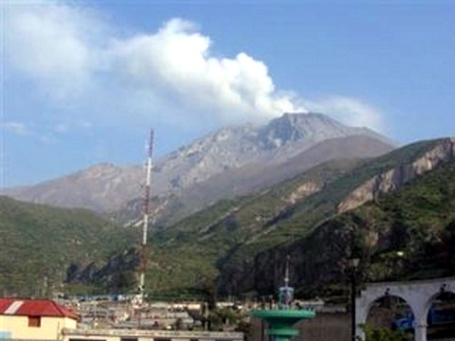 |
Figure 2. Photo of Ubinas on 31 March 2006 showing an eruption plume rising from the summit crater. Photo by the Perúvian Civil Defense taken from Moquegua city, provided courtesy of the Associated Press. |
Ash emissions through 10 April covered local villages and damaged crops. Clear crop damage was visible around the village of Querapi, with potato and alfalfa leaves and flowers blemished in spots. This is the critical growing time for the crop, and thus any damage is serious for the local farmers. Cattle have been seen suffering from diarrhea.
Short periods of seismic recordings have been made at a site 2,500 m NW of the crater rim. On 20 November 2004 only 16 local events were recorded over 12 hours. In February 2005 there where 96 events over the same time period. Over 12 hours on 27 March 2006 there were 115 events. During this last interval, low-amplitude tremor events lasting 3 minutes on average were recorded, as well as long-period (LP) events. Over the 12 hours of observation the following events were recorded: 62 LP, 18 LP with precursors, 10 volcano-tectonic (VT), five VT with precursors, and 20 tremor events.
Geological Summary. The truncated appearance of Ubinas, Perú's most active volcano, is a result of a 1.4-km-wide crater at the summit. It is the northernmost of three young volcanoes located along a regional structural lineament about 50 km behind the main volcanic front. The growth and destruction of Ubinas I was followed by construction of Ubinas II beginning in the mid-Pleistocene. The upper slopes of the andesitic-to-rhyolitic Ubinas II stratovolcano are composed primarily of andesitic and trachyandesitic lava flows and steepen to nearly 45°. The steep-walled, 150-m-deep summit crater contains an ash cone with a 500-m-wide funnel-shaped vent that is 200 m deep. Debris-avalanche deposits from the collapse of the SE flank about 3,700 years ago extend 10 km from the volcano. Widespread Plinian pumice-fall deposits include one from about 1,000 years ago. Holocene lava flows are visible on the flanks, but activity documented since the 16th century has consisted of intermittent minor-to-moderate explosive eruptions.
Information Contacts: Orlando Macedo, Observatorio de Cayma-Arequipa, Instituto Geofísico del Perú at Arequipa city (IGP-Arequipa), Urb. La Marina B-19, Cayma, Arequipa, Perú; Jersy Marino, Instituto Geologico, Minero y Metalurgico (INGEMMET), Perú; Benjamin van Wyk, Laboratoire Magmas et Volcans (LMV), OPGC, France; Jean-Philippe Métaxian, Laboratire de Geophysique Interne et Tectonophysique-Univ de Savoie, France; Perúvian Civil Defense (URL: http://www.indeci.gob.pe/); Diario Digital Sur Noticias, Tacna, Perú (URL: http://www.surnoticias.com/); Associated Press (URL: http://www.ap.org/).