Report on Kilauea (United States) — April 2006

Bulletin of the Global Volcanism Network, vol. 31, no. 4 (April 2006)
Managing Editor: Richard Wunderman.
Kilauea (United States) Maps of past year's surface lava flows and photos of lava entering the sea
Please cite this report as:
Global Volcanism Program, 2006. Report on Kilauea (United States) (Wunderman, R., ed.). Bulletin of the Global Volcanism Network, 31:4. Smithsonian Institution. https://doi.org/10.5479/si.GVP.BGVN200604-332010
Kilauea
United States
19.421°N, 155.287°W; summit elev. 1222 m
All times are local (unless otherwise noted)
This report covers the interval 31 January 2005 to 7 February 2006 and is drawn exclusively from U.S. Geological Survey Hawaiian Volcanic Observatory (USGS HVO) sources. During this interval, active lava flows during tended to remain along the W to central portions of the existing field (figures 173 and 174). On 31 January 2005, lava from Kīlauea began pouring into the ocean at two entry points. The Ka`ili`ili entry to the E of the flow field was the largest and was fed by the large W arm of the Prince Kuhio Kalaniana (PKK) lava flow. The West Highcastle ocean entry was supplied by the W branch of the W arm of the PKK lava flow.
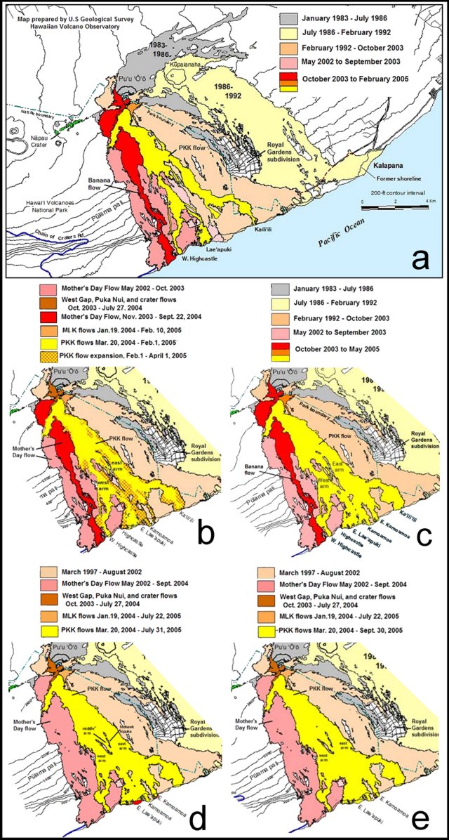 |
Figure 173. A series of maps portraying Kīlauea's surface lava flows at various times during 31 January 2005 to 7 February 2006. New vents opened at the southern base of Pu`u `O`o on 19 January 2004. Map panels are as follows: a) A map with features as of February 2005, b) as of April 2005, c) as of May 2005, d) as of 31 July 2005, and e) as of 30 September 2005. Courtesy of Christina Heliker, USGS HVO. |
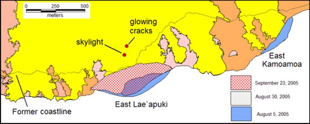 |
Figure 174. Map portraying Kīlauea's near-shore and coastal lava flows areas in the vicinity of East Lae'apuki and East Kamoamoa as of 23 September 2005. Courtesy of Christina Heliker, USGS HVO. |
From 7 February 2005 to 20 February 2005, lava flows were visible on the Pulama pali fault scarp and on the coastal flat. Instruments recorded a few small earthquakes and no tremor at Kīlauea's summit. At Pu`u `O`o, volcanic tremor remained moderate. Small amounts of deformation were recorded.
On 21 February 2005 a new ocean entry formed, named E Lae`apuki. The entry was located between the other two ocean entries (Ka`ili`ili and West Highcastle) that had been active since 31 January 2005. This was the first time there had been three ocean entries active since early 2003 (figures 173-175).
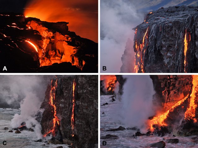 |
Figure 175. Photos of Kīlauea activity taken along the coast on 21 February 2005. (A) A photo showing the walls of a large crack into which lava pours at E Lae`apuki. Sea cliff is to the right, at shelf's edge beyond the glow. (B and C, respectively) The top and bottom of lava falls at E Lae`apuki ocean entry looking W. (D) A closer view focused on showing the base of the lava falls. The sea cliff's height is ~ 12 m. Courtesy of HVO. |
During 23-26 February 2005, lava from Pu`u `O`o entered the sea at three ocean entries–West Highcastle, East Lae'apuki, and Ka`ili`ili–spots along 4.7 km of the island's SE coast (figure 176). Lava may have stopped flowing into the sea at the W entry (West Highcastle) on 26 February 2005. The number of surface lava flows diminished in comparison to the previous weeks, and small earthquakes continued to occur at Kīlauea's summit without accompanying tremor. Tremor remained at moderate levels at Pu`u `O`o, and as of 28 February 2005, deflation had occurred at Pu`u `O`o for more than a week and at the summit since 24 February 2005.
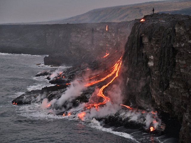 |
Figure 176. A Kīlauea photograph taken on 23 February 2005 depicting active lava delta construction at E Lae`apuki ocean entry. Note the fan building outward from the sea cliff and the person (upper right) for scale. Courtesy of USGS HVO. |
During the month of March 2005, lava from Kīlauea continued to enter the ocean at the Ka`ili`ili and E Lae`apuki, but there were no signs of activity at the West Highcastle entry. Surface lava flowed down the Pulami pali fault scarp and the coastal flat. Small earthquakes occurred at Kīlauea's summit, and no tremor was recorded. Tremor remained at moderate levels at Pu`u `O`o.
On 29 March 2005, lava from Kīlauea entered the ocean at five areas. The largest, named Kamoamoa, consisted of six or more places where lava entered the water along the front of a growing lava delta (figure 177). At one of the two Highcastle entries, a cascade of lava streamed down the old sea cliff. A bright glow came from Ka`ili`ili entry, and a weak glow from E Highcastle entry. Seismicity remained above background levels at Kīlauea's summit, consisting mainly of tremor and some long-period earthquakes. Surface waves from an M 8.7 earthquake on 28 March 2005 off Sumatra, Indonesia disturbed tilt measurements at Kīlauea but otherwise the tilt change was small.
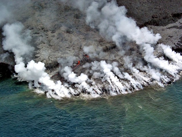 |
Figure 177. A photo taken 25 March 2005 showing Kīlauea's new Kamoamoa ocean entry, located just NE of East Lae'apuki. Descending lava poured over an old sea cliff to land upon, and flow across, an old delta; it then dropped into the sea, forming a new delta. Courtesy of USGS HVO. |
Lava from Kīlauea continued to flow into the ocean at several points during 1-13 April 2005. Seismicity remained above background levels at Kīlauea's summit, consisting mainly of tremor and some long-period earthquakes. Volcanic tremor was at moderate levels at Pu`u `O`o. During 14-19 April, surface lava flows from Kīlauea were visible on the Pulama pali fault scarp but lava was not seen entering the ocean.
Seismicity remained above background levels at Kīlauea's summit during 14-19 April 2005, consisting mainly of tremor and some long-period earthquakes. Volcanic tremor was at moderate levels at Pu`u `O`o. Episodes of inflation and deflation occurred during the week.
During 21-25 April, there were fewer surface lava flows visible at Kīlauea than during the previous week. On 24 April a small amount of lava again began to enter the sea. Seismicity remained above background levels at Kīlauea's summit, consisting mainly of tremor and some long-period earthquakes.
During 27 April-3 May 2005, lava entered the ocean at the Kamoamoa entry. Numerous surface lava flows were visible on the coastal flat. Seismicity remained above background levels at Kīlauea's summit, consisting of both tremor and long-period earthquakes.
A third ocean entry, in the E Lae`apuki area, became active on 5 May 2005. That entry and the Far E Lae`apuki entry were both being fed by lava falls down the old sea cliff and were relatively small. Based on the brighter glow, the Kamoamoa entry was thought to be more substantial. By the morning of 9 May lava was streaming over the old sea cliff in four locations: two falls went into the sea and two other falls landed on an old delta. The branch of the PKK flow feeding E Lae`apuki sprung numerous new lava flows on 9 May. The next day, the middle branch of the PKK flow developed an open-channel stream on the Pulama pali; it was 10-20 m wide, 500-600 m long, and moving rapidly.
Ocean entries remained active during 11-17 May 2005 in the E Lae`apuki and Kamoamoa areas. By 16 May the E Lae`apuki and E Kamoamoa entries both had benches ~ 350 m long and up to 75 m wide. A large plume from West Highcastle on 10 May probably recorded a collapse of part of that lava delta, which has been inactive for the past several weeks following growth in March and April. The middle branch of the PKK flow remained active and extended down Pulama Pali. The E branch reached out farther but was narrower and contained fewer breakouts. The W branch was reduced to a cluster of breakouts about halfway down the pali. Glow was seen from all of the Pu`u `O`o crater vents, as well as the MLK vent at the SW foot of the cone.
During 18-31 May 2005, lava from Kīlauea continued to enter the sea at three areas. Surface lava flows were visible on the coastal plain and on the Pulama pali fault scarp. During 1-4 June 2005 lava entered the sea at three points along the S flank of Kīlauea, and then at only two points through 7 June. Small surface lava flows were visible on the Pulama pali fault scarp and the coastal flat.
Lava again entered the sea at three points on 13 June. During the 14-21 June lava continued to enter the sea and there was a small number of lava flows on the Pulama pali fault scarp. On 22 June lava in the W branch of the current flow descended onto the coastal flat for the first time in several months. On 24 June it was noted that Kīlauea's summit continued its inflation, while Pu`u `O`o was deflating during the same period.
On 27 June part of the active E Lae`apuki lava delta collapsed. Lava stored within the delta gushed out onto the surface and into the water. Fountains of lava reported to be about 25 m high spurted from the central part of the delta soon afterward. Lava also entered the sea during 4-5 July and a few surface flows were on Pulama pali.
During 6-19 July 2005, lava continued to enter the sea at E Kamoamoa and E Lae`apuki. The latter entry was much larger, with several entry points. E Kamoamoa barely glowed. Surface lava was visible along the PKK lava flow throughout the month of July. Background volcanic tremor remained above normal levels at Kīlauea's summit and at moderate levels at Pu`u `O`o. Slight inflation and deflation occurred at the volcano. An M 4.5 earthquake occurred on 25 July at 2209 along the SE edge of Kīlauea's SW rift zone at a depth of ~ 30 km.
Up to seven ocean-entry points were visible off the W-facing front of the E Lae`apuki lava delta during 3-9 August; still others were hidden from view off the E-facing front. On Pulama pali, the W branch of the PKK flow reached its greatest extent of the week on 5 August, when it broadened to include hundreds of meters of scattered breakouts and reached from 460 m down to 260 m elevation. During 15-16 August 2005, surface lava at Kīlauea was again visible on the W and E branches of the PKK lava flow. Lava continued to enter the sea at the E Lae`apuki entry through 5 September. Background volcanic tremor was near normal levels at Kīlauea's summit and at moderate levels at Pu`u `O`o cone. There were small periods of inflation and deflation at Kīlauea's summit and Pu`u `O`o. By 22 August, surface lava on the W branch of the PKK lava flow was no longer visible. On 27 August, part of a lava-bench collapsed.
Throughout September, lava entered the sea at the E Lae`apuki area with surface lava flows visible on the Pulama Pali fault scarp. Lava filled a scar left by the lava-bench collapse on 27 August. Background volcanic tremor continued to remain around normal levels at the summit. Volcanic tremor was at moderate levels at Pu`u `O`o. On 11 September, substantial deflation at the volcano was followed by sharp inflation. On 19 September, several small shallow earthquakes occurred along the Kao`iki fault system with small amounts of inflation and deflation.
In October 2005, lava from Kīlauea continued to enter the sea at the E Lae`apuki area, and surface lava flows were visible along the PKK lava flow. Lava flows continued to enter the sea at E Lae`apuki area, mostly NE of the point of the lava delta. On 18 October, weak surface lava flows were visible at Kīlauea and one cascade of lava flowed off of the western front of the E Lae`apuki delta.
Activity during November 2005 was similar to the previous month. Lava continued to enter the sea at the E Lae`apuki area and surface lava flows were visible on the Pulama pali fault scarp. Background volcanic tremor was near normal levels at Kīlauea's summit.
A lava-bench collapse in the E Lae`apuki area on 29 November 2005 was the largest bench collapse of the current eruption, which began in January 1983. The collapse lasted several hours, sending the 137,588 m2 of bench and an additional 40,467 m2 of adjacent cliff, into the sea. The collapse left a 20-m-high cliff, from which a 2 m thick stream of lava was emitted from an open lava tube. Cracks had been observed on the inland portion of the bench several months earlier; visitors were not allowed near the bench, but a viewing area was provided ~ 3 km away. Growth of the new delta at E Lae`apuki was continuing as of 6 December 2005. At that time breakouts were also active on Pulama Pali.
During December, lava from Kīlauea continued to enter the sea at the E Lae`apuki area and surface lava flows were visible on the Pulama pali fault scarp.
From 28 December 2005 to 9 January 2006, lava from Kīlauea continued to enter the sea at the E Lae`apuki area building a new lava delta with surface lava flows visible on the Pulama pali fault scarp. Background volcanic tremor was near normal levels at Kīlauea's summit. Volcanic tremor reached moderate levels at Pu`u `O`o. Small amounts of deformation occurred. On 10 January, the summit deflation switched abruptly to inflation after a loss of 5.2 µrad. Relatively high tremor occurred at this time. The tremor quickly dropped, becoming weak to moderate when deflation ended, with seismicity punctuated by a few small earthquakes. By 13 January, background volcanic tremor was near normal levels at Kīlauea's summit and reached moderate levels at Pu`u `O`o. On 14 January, the lava delta was about 500 m long (parallel to shore) and still 140 m wide. By the end of the month the lava delta was 615 m long and 140 m wide. Background volcanic tremor was near normal levels at Kīlauea's summit, with numerous shallow earthquakes occurring at the summit and upper E rift zone during several days.
During 2-7 February 2006, lava from Kīlauea continued to enter the sea at the E Lae`apuki area and surface lava flows were visible on the Pulama pali fault scarp. Background volcanic tremor was near normal levels at Kīlauea's summit, with numerous shallow earthquakes continuing to occur at the summit and upper E rift zone. Volcanic tremor reached moderate levels at Pu`u `O`o. Small amounts of inflation and deflation were reported. From mid-to-late February, surface lava flows were not visible on Kīlauea's Pulama pali fault scarp due to lava traveling underground through the PKK lava tube until reaching E Lae`apuki lava delta and flowing into the sea. Observations on 7 February 2006 revealed that the lava delta had broadened 120 m W since 30 January 2006.
Geological Summary. Kilauea overlaps the E flank of the massive Mauna Loa shield volcano in the island of Hawaii. Eruptions are prominent in Polynesian legends; written documentation since 1820 records frequent summit and flank lava flow eruptions interspersed with periods of long-term lava lake activity at Halemaumau crater in the summit caldera until 1924. The 3 x 5 km caldera was formed in several stages about 1,500 years ago and during the 18th century; eruptions have also originated from the lengthy East and Southwest rift zones, which extend to the ocean in both directions. About 90% of the surface of the basaltic shield volcano is formed of lava flows less than about 1,100 years old; 70% of the surface is younger than 600 years. The long-term eruption from the East rift zone between 1983 and 2018 produced lava flows covering more than 100 km2, destroyed hundreds of houses, and added new coastline.
Information Contacts: Hawaiian Volcano Observatory (HVO), U.S. Geological Survey, PO Box 51, Hawaii National Park, HI 96718, USA (URL: https://volcanoes.usgs.gov/observatories/hvo/).