Report on Lascar (Chile) — April 2006

Bulletin of the Global Volcanism Network, vol. 31, no. 4 (April 2006)
Managing Editor: Richard Wunderman.
Lascar (Chile) Five-day eruption sequence in April 2006; plume seen 220 km away
Please cite this report as:
Global Volcanism Program, 2006. Report on Lascar (Chile) (Wunderman, R., ed.). Bulletin of the Global Volcanism Network, 31:4. Smithsonian Institution. https://doi.org/10.5479/si.GVP.BGVN200604-355100
Lascar
Chile
23.37°S, 67.73°W; summit elev. 5592 m
All times are local (unless otherwise noted)
Lascar's eruption on 4 May 2005 (BGVN 30:05) was followed by a new eruptive cycle, which began on 18 April 2006 and lasted 5 days. Observers familiar with Lascar judged this eruptive episode unusual compared to those observed previously in terms of eruptive character, frequency, and duration time. The Volcanic Ash Advisory Center (VAAC) in Buenos Aires and Servicio Metererológico Nacional of Argentina detected the eruption from satellite images, and aircraft warnings were posted. All of the times cited are in UTC (local time = UTC - 4 hours).
Eruptions start, 18 April. Four explosions registered (at 1520, 1722, 1900, and 2100 hours UTC). The first explosion, the largest of four, was visible from El Abra cooper mine (220 km NW) and reached ~ 10 km above the summit crater (figure 33). The shape of the eruptive column suggested that it reached the tropopause (~ 15 km altitude in this region). The white to gray plume, containing little ash but a large amount of water, dispersed to the NNE.
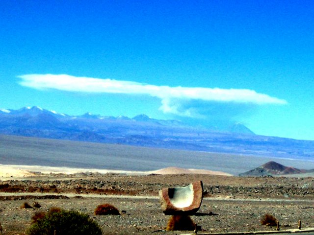 |
Figure 33. Lascar's first explosion of 18 April 2006 as photographed from El Abra copper mine, 220 km NW from volcano. Courtesy of personnel at the El Abra copper mine. |
The second explosion reached 3 km above the summit crater, while the third and fourth explosions reached 800 m. These latter eruptive plumes were gray colored, had higher contents of ash than the first explosion, and were dispersed NNE. Only slight ash fall was registered on the N side of the volcano. No seismic activity or eruption noises were registered. Analysis of GOES satellite images (figure 34) indicated that for the first and second eruptive plumes the mean horizontal velocities were 70 and 85 km/hour, respectively, while the maximum plume areas were ~ 8,240 and 1,074 km2, respectively. Minimum volumes erupted were ~ 4.1 x 10⁶ and ~ 0.54 x 10⁶ m3 assuming a hypothetical ash fall deposit of 0.5 mm over the stated areas. The third and fourth explosions were not detected by satellite.
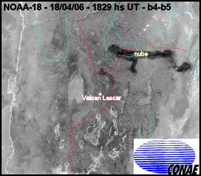 |
Figure 34. GOES satellite image capturing Lascar's first and second eruptive plumes. Rivers and international borders are also shown. Image is for 1829 UTC on the 18 April 2006. The first plume (oblong black area labeled 'cloud' in Spanish?'nube') stretched over N Argentina and S Bolivia. A second plume appears as a much smaller dark area between Lascar and the first plume. It lay over the NE Chilean border. Courtesy of Comisión Nacional de Asuntos Espaciales (CONAE), Argentina. |
19-22 April eruptions and comparative calm that followed. On 19 April 2006 at 1504 hours (UTC) an explosion generated a gray-colored eruptive column that reached 3 km above the summit crater and was dispersed NNE. Slight ash fall was noted on the N side of the volcano. Neither seismic activity nor eruption noises were reported. Two explosions were recorded 20 April at 1505 and 1739 hours (UTC). The first eruptive plume reached 2.5 km above the summit crater and contained a small amount of ash. The plume from the second explosion, the larger of the pair, reached 7 km above the crater. The eruption lasted 1 hour and 50 min. Both plumes were dispersed N and slight ash fall was registered on the N side of the volcano. No seismic activity or eruption noises were registered.
Analysis of satellite data from the sequence of GOES images (figure 35) indicated that the first and second eruptive plumes had mean horizontal velocities of 40 km/h, while the maximum areas were ~ 430 and ~ 800 km2, respectively. Minimal volumes erupted were ~ 0.4 x 10⁶ and ~ 0.2 x 10⁶ m3, again assuming a hypothetical 0.5 mm ash-fall deposit.
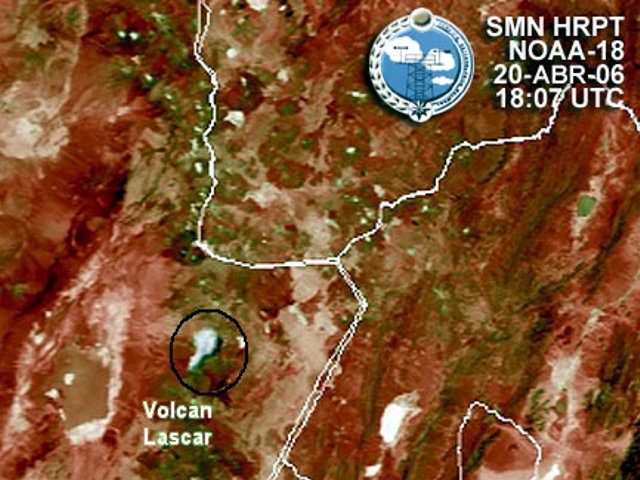 |
Figure 35. GOES satellite image of Lascar showing the second eruptive plume (black circle) at 1807 hours (UTC) of 20 April eruption dispersed to NE. Courtesy of Servicio Meteorológico Nacional and Comisión Nacional de Asuntos Espaciales (CONAE), Argentina. |
Two explosions were recorded on 21 April 2006 at 1248 and 1547 UTC, each lasting ~ 15 minutes. Their eruptive columns reached 3 km above the summit crater and rapidly dispersed ESE. Seismic activity and eruption noises were not noted.
On 22 April at 1518 UTC an explosion generated an eruptive column that reached 3 km above the summit crater; it was blown SE. Local inhabitants heard subterranean noises. On 23 April at 1600 UTC an explosion generated a gray-colored eruptive column that reached 2.5 km above the summit crater and dispersed NNW (figure 36). Seismic activity and eruption noises were not registered. During the following 2 days, the color of the plume was white and it's top remained ~ 1.5 km above the crater.
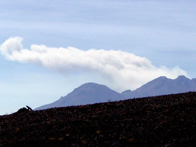 |
Figure 36. Photograph of Lascar taken 23 April 2006 from the SW border of the Atacama salar (salt pan), ~ 40 km SW of the volcano. Courtesy of Gabriel González. |
Other studies. After the 4 May 2005 eruption (BGVN 30:05), a team of scientists from Universidad Católica del Norte (UCN) carried out a gas sampling campaign on new fumaroles around the S edge of the central active crater. They used the direct sampling of fumaroles technique described by Giggenbach (1975) and Giggenbach and Goguel (1989). Gas data showed increasing amounts of H2O, H2S, and CH4 with respect to samples taken in 2002 from inside the active crater (Tassi et al., 2004). However, acid gases also displayed very high values. During December 2005 a team of scientists from UCN and Universidad Autónoma de México (UNAM) carried out field investigations to generate hazard maps.
Scientists from Università degli Studi di Firenze (Italy) and Universidad Católica del Norte (Chile) are conducting a systematic gas sample campaign at Lascar and other active volcanoes in the Central Volcanic Zone (e.g. Putana, Lastarria, and Isluga). Finally, scientists from the Universidad Católica del Norte, the Universidad Nacional de Salta and SEGEMAR (Argentina) are processing data from Landsat Thematic Mapper (TM) and Enhanced Thematic Mapper Plus (ETM+) and Advanced Spaceborne Thermal Emission and Reflection Radiometer (ASTER) images, with the objective of understanding the behavior of Lascar volcano during the 1998-2004 period.
References. Giggenbach, W., 1975, A simple method for the collection and analysis of volcanic gas sample: Bulletin of Volcanology, 39, 132?145.
Giggenbach, W., and Goguel, R., 1989, Collection and analysis of geothermal and volcanic water and gas discharges: DSIR Chemistry, Rept. No. 2401.
Matthews, S., Gardeweg, M., and Sparks, R., 1997, The 1984 to 1996 cyclic activity of Lascar volcano, northern Chile: cycles of dome growth, dome subsidence, degassing and explosive eruptions: Bulletin of Volcanology, v. 59, p. 72-82.
Tassi, F., Viramonte, J., Vaselli, O., Poodts, M., Aguilera, F., Martínez, C., Rodríguez, L., and Watson, I., 2004, First geochemical data from fumarolic gases at Lascar volcano, Chile: 32nd International Geological Congress, Florence, August 20-28, 2004.
Viramonte, J., Aguilera, F., Delgado, H., Rodríguez, L., Guzman, K., Jiménez, J., and Becchio, R., 2006, A new eruptive cycle of Lascar Volcano (Chile): The risk for the aeronavigation in northern Argentina. Garavolcan 2006, Tenerife, Spain.
Geological Summary. Láscar is the most active volcano of the northern Chilean Andes. The andesitic-to-dacitic stratovolcano contains six overlapping summit craters. Prominent lava flows descend its NW flanks. An older, higher stratovolcano 5 km E, Volcán Aguas Calientes, displays a well-developed summit crater and a probable Holocene lava flow near its summit (de Silva and Francis, 1991). Láscar consists of two major edifices; activity began at the eastern volcano and then shifted to the western cone. The largest eruption took place about 26,500 years ago, and following the eruption of the Tumbres scoria flow about 9000 years ago, activity shifted back to the eastern edifice, where three overlapping craters were formed. Frequent small-to-moderate explosive eruptions have been recorded since the mid-19th century, along with periodic larger eruptions that produced ashfall hundreds of kilometers away. The largest historical eruption took place in 1993, producing pyroclastic flows to 8.5 km NW of the summit and ashfall in Buenos Aires.
Information Contacts: Felipe Aguilera, Eduardo Medina, and Karen Guzmán, Programa de Doctorado en Ciencias mención Geología and Departamento de Ciencias Geológicas, Universidad Católica del Norte, Avenida Angamos 0610, Antofagasta, Chile (URL: http://www.geodoctorado.cl, http://www.ucn.cl/); José G. Viramonte, Raúl Becchio, and Marcelo J. Arnosio, Instituto GEONORTE and CONICET, Universidad Nacional de Salta, Buenos Aires 177, Salta 4400, Argentina (URL: http://www.unsa.edu.ar/); Ricardo Valenti and Sergio Haspert, Servicio Metereológico Nacional, Argentina; Hugo G. Delgado, Instituto de Geofísica, Universidad Nacional Autónoma de México (UNAM), Coyoacán 04510, México, D.F.; Buenos Aires Volcanic Ash Advisory Center (VAAC), Servicio Meteorológico Nacional-Fuerza Aérea Argentina, Buenos Aires, Argentina (URL: http://www.smn.gov.ar/vaac/buenosaires/productos.php).