Report on Lamington (Papua New Guinea) — May 2006
Bulletin of the Global Volcanism Network, vol. 31, no. 5 (May 2006)
Managing Editor: Richard Wunderman.
Lamington (Papua New Guinea) Mild vapor emission and earthquakes through March 2006
Please cite this report as:
Global Volcanism Program, 2006. Report on Lamington (Papua New Guinea) (Wunderman, R., ed.). Bulletin of the Global Volcanism Network, 31:5. Smithsonian Institution. https://doi.org/10.5479/si.GVP.BGVN200605-253010
Lamington
Papua New Guinea
8.95°S, 148.15°E; summit elev. 1680 m
All times are local (unless otherwise noted)
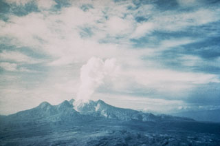
Lamington has continued the trend of relative quiet during mid-January to the end of March 2006. Consistent reporting has been difficult due to overcast weather. Small volumes of thin white vapor were released during this time. No audible noises or glow were recorded. High frequency earthquakes continued to be recorded. The highest total was 25 recorded on 18 February.
Geological Summary. Lamington is an andesitic stratovolcano with a 1.3-km-wide breached summit crater containing a lava dome that rises above the coastal plain of the Papuan Peninsula of New Guinea north of the Owen Stanley Range. A summit complex of lava domes and crater remnants tops a low-angle base of volcaniclastic deposits dissected by radial valleys. A prominent broad "avalanche valley" extends northward from the breached crater. Ash layers from two early Holocene eruptions have been identified. In 1951 a powerful explosive eruption produced pyroclastic flows and surges that swept all sides of the volcano, killing nearly 3,000 people. The eruption concluded with growth of a 560-m-high lava dome in the summit crater.
Information Contacts: Ima Itikarai and Herman Patia, Rabaul Volcano Observatory (RVO), P.O. Box 386, Rabaul, Papua New Guinea.