Report on NW Rota-1 (United States) — May 2006
Bulletin of the Global Volcanism Network, vol. 31, no. 5 (May 2006)
Managing Editor: Richard Wunderman.
NW Rota-1 (United States) Views of submarine volcano ejecting lava and bombs
Please cite this report as:
Global Volcanism Program, 2006. Report on NW Rota-1 (United States) (Wunderman, R., ed.). Bulletin of the Global Volcanism Network, 31:5. Smithsonian Institution. https://doi.org/10.5479/si.GVP.BGVN200605-284211
NW Rota-1
United States
14.601°N, 144.775°E; summit elev. -517 m
All times are local (unless otherwise noted)
During 18 April-13 May 2006, scientists from the National Oceanic and Atmospheric Agency (NOAA) and Oregon State University completed the 2006 Submarine Ring of Fire Expedition aboard the research vessel Melville. This expedition was the third in a series of explorations of the submarine volcanoes lying along the Mariana intra-ocean volcanic arc. That arc extends from S of the island of Guam northward more than 1,450 km through the Commonwealth of the Northern Mariana Islands (see map in above report on Daikoku). A previous expedition to Northwest Rota-1 in 2004 discovered and named this volcano and found it erupting (BGVN 29:03). Daily logs of the 2006 expedition, including photographs and video clips, can be viewed on the NOAA Ocean Explorer web site noted below, from which much of this report was taken.
On 23 and 24 April 2006, the unmanned (remotely operated vessel, ROV) submersible Jason 2 revisited Brimstone Pit, a spot on the volcano where an ash-and-gas plume was discovered in 2004 and observed again in 2005 (Embley and others, 2004 and 2006). The changes were striking. According to Robert Embley (Oregon State University press release, 25 May 2006), "we saw features of submarine volcanic activity never before directly observed, including explosions of lava from a crater accompanied by a red glow and voluminous volcanic gases and ejected rocks." A degassing event at Brimstone Pit began releasing bubbles that formed a growing submarine plume cloud. The Pit, at a depth of 560 m, was significantly deeper (by ~ 20 m) than it was in the previous visits and there appeared to have been a recent collapse of the summit area. The Pit exuded a sluggish pulsating cloud of white color along with some gas bubbles. Some time later, the pit was almost filled with the white cloud, which appeared to come from the lavas themselves. The observers concluded that they witnessed lava extruding on the seafloor.
Particle plumes were mapped using a light-scattering sensor (LSS), part of the CTD (conductivity-temperature-depth) instrument package towed over the summit and flanks of the volcano. The CTD revealed layers of turbid (cloudy) water extending as far as 8 km down the S flank, and to depths up to 2,900 m. The turbid layers may arise from periodic collapse of the unstable slopes of volcanic fallout material similar to that found in the white cloud observed at the summit.
Submersible dives on 25 April 2006 to the Brimstone Pit revealed a lava flow forming there. The initial approach to the Pit revealed a line of bubbles (mainly CO2) escaping from a fracture in the underlying rock. However, in place of the previously flat ground that described the Pit on 24 April, a small ash cone had formed. It was ~ 6 m in diameter with walls about 1 m high, made up entirely of fine-grained ash. As the submersible approached, observers saw a plume discharging out of the cone's center and, on closer inspection, it appeared that ash was raining out of the bottom of the plume and falling onto the flanks of the small cone.
Near Brimstone Pit, the submersible collected a piece of newly erupted andesite lava containing elemental sulfur filling vesicles. The lava flow advanced but slowly, traveling forward bit by bit, chunk by chunk. As the lava advanced, the flow's toe vigorously degassed. The emitted gas and the associated plume took on a yellow hue. Scientists interpreted the escaping gases as mainly sulfur-rich (SO2 and H2S), which can mix with and make the surrounding seawater strongly acidic and precipitate elemental sulfur, the source of the plume's yellow hue. Liquid native sulfur inside the plume was seen raining on the seafloor as small droplets and filled in the numerous holes in the lava where the gases escaped. Locally, carbon dioxide formed bubbles in front of the advancing lava. These different gases provided the force behind the vigorous 'mini-explosions' within the lava flow.
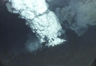
Finishing the last of six dives at Northwest Rota-1 on 29 April 2006, and combining observations from the two previous expeditions, scientists developed some conclusions about processes at this extremely dynamic site. Prior to arrival in 2006, a major landslide must have originated near Brimstone Pit. During the first day of 2006 submersible observations, a turbid layer generated by the slide surrounded the lower flanks. The next day, when the water had cleared, half of Brimstone Pit had fallen away and the seafloor around the vent was swept clean of recent lava. Over the next week, eruptive activity gradually increased in intensity and vigor. By the end of the week, a 5-m-high cone made of ash and lava blocks had built up over the vent, and the turbid layer on the flanks was almost gone. On the last dive, scientists saw glowing lava jetting from the vent (figure 5).
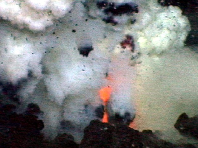 |
Figure 5. Glowing red lava jetting out of the vent at Northwest Rota-1 Brimstone Pit at depth of 560 m. Photo taken from the submersible Jason II, 29 April 2006. Image courtesy of Submarine Ring of Fire 2006 Exploration, NOAA Vents Program. |
The scientists concluded that observing explosive volcanic activity at a submarine volcano was easier and more revealing in many ways than on land, perhaps because the eruptive activity, although violent at times, is usually limited to a small area due to the dampening effect of the surrounding water (figure 6). For example, at Brimstone Pit the pressure of 560 m of water over the site reduced the power of the explosive bursts. Also, the water quickly slows down the rocks and ash violently thrown out of the vent. The scientists viewed the release of volcanic gases from the erupting lava with new clarity, with the help of the streams of bubbles and multicolored plumes as they were emitted. In addition, the scientists recorded the activity using a portable underwater microphone (hydrophone).
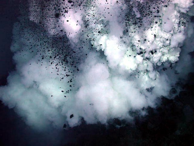 |
Figure 6. Eruption at Brimstone Pit in Northwest Rota-1 at a depth of 560 m. Photo taken by the submersible Jason II, 29 April 2006. Image courtesy of Submarine Ring of Fire 2006 Exploration, NOAA Vents Program. |
Chadwick and his associates at NOAA have identified and named 56 seamounts in the Mariana Arc, 11 of which show hydrothermal activity, based primarily on CTD instrument tows (table 1; see figure 5 for map showing locations).
Table 1. Seamounts in the Mariana arc that are active volcanos based on submersible observations and/or that registered signs of hydrothermal activity on CTD tows. Brief comments on noteworthy observations from several of those visited in 2006 are included. Courtesy of William Chadwick, NOAA, June 2006.
| Seamounts (listed S to N) | Shallowest summit depth | Longitude | Latitude | Comments |
| [Seamount X] | 1,230 m | 144.0167°E | 13.2500°N | -- |
| Northwest Rota-1 | 517 m | 144.7750°E | 14.6000°N | -- |
| Esmeralda Bank | 54 m | 145.2458°E | 14.9583°N | -- |
| E. Diamante | 127 m | 145.6583°E | 15.9167°N | Active, metal-rich, ephemeral 'black smokers' shallowest yet discovered. |
| Zealandia Bank | 144 m | 145.8000°E | 16.8833°N | -- |
| Maug | 54 m | 145.2217°E | 20.0208°N | -- |
| NW Uracas | 703 m | 144.8400°E | 20.5833°N | -- |
| Daikoku | 323 m | 144.1942°E | 21.3242°N | See report in this issue. |
| NW Eifuku | 1,551 m | 144.0433°E | 21.4875°N | Liquid CO2 venting from 'white smokers.' |
| Kasuga | 297 m | 143.6417°E | 21.6100°N | -- |
| Nikko | 392 m | 142.3255°E | 23.0784°N | Sulfur chimneys, boiling pots of molten sulfur surrounded by a thin crust on a larger lava lake. |
References. Embley, R.W., Baker, E.T., Chadwick, W.W., Jr., Lipton, J.E., Resing, J.A., Massoth, G.J., and Nakamura, K., 2004, Explorations of Mariana Arc volcanoes reveal new hydrothermal systems: EOS, Transactions, American Geophysical Union, v. 85, no. 2, p. 37, 40.
Embley, R.W., Chadwick, W.W., Jr, Baker, E.T., Butterfield, D.A., Resing, J.A., de Ronde, C. E.J., Tunnicliffe, V., Lupton, J.E., Juniper, S.K., Rubin, K.H., Stern, R.J., Lebon, G.T., Nakamura, K., Merle, S.G., Hein, J.R., Wiens, D.A., and Tamura, Y., 2006, Long-term eruptive activity at a submarine arc volcano: Nature, v. 441, no. 7092, p. 494-497.
Oregon State University, 25 May 2006, Press Release: Nature paper details eruption activity at submarine volcano: College of Oceanic and Atmospheric Science (COAS), 104 COAS Admininstration Building, Corvallis, OR 97331.
Geological Summary. A submarine volcano detected during a 2003 NOAA bathymetric survey of the Mariana Island arc was found to be hydrothermally active and named NW Rota-1. The basaltic to basaltic andesite seamount rises to within 517 m of the ocean surface SW of Esmeralda Bank, 64 km NW of Rota Island and ~100 km N of Guam. When Northwest Rota-1 was revisited in 2004, a minor submarine eruption from a vent named Brimstone Pit on the upper south flank about 40 m below the summit intermittently ejected a plume several hundred meters high containing ash, rock particles, and molten sulfur droplets that adhered to the surface of the remotely operated submersible vehicle. The active vent was funnel-shaped, about 20 m wide and 12 m deep. Prominent structural lineaments about a kilometer apart cut across the summit of the edifice and down the NE and SW flanks.
Information Contacts: William W. Chadwick, Jr., Cooperative Institute for Marine Resources Studies (CIMRS), NOAA Pacific Marine Environmental Laboratory (PMEL), 2115 SE OSU Drive, Newport, OR 97365 USA; NOAA Ocean Explorer (URL: http://oceanexplorer.noaa.gov/explorations/06fire/welcome.html).