Report on St. Helens (United States) — May 2006

Bulletin of the Global Volcanism Network, vol. 31, no. 5 (May 2006)
Managing Editor: Richard Wunderman.
St. Helens (United States) Intracrater lava dome continues to grow through at least May 2006
Please cite this report as:
Global Volcanism Program, 2006. Report on St. Helens (United States) (Wunderman, R., ed.). Bulletin of the Global Volcanism Network, 31:5. Smithsonian Institution. https://doi.org/10.5479/si.GVP.BGVN200605-321050
St. Helens
United States
46.2°N, 122.18°W; summit elev. 2549 m
All times are local (unless otherwise noted)
From August to December 2005, the lava dome inside the crater of Mount St. Helens continued to grow, accompanied by low rates of seismicity, low emissions of steam and volcanic gases, and minor production of ash (BGVN 30:12). The hazard status was at Volcano Advisory (Alert Level 2); aviation color code Orange.
Based on the online reports of the Cascades Volcano Observatory (CVO) of the U.S. Geological Survey (USGS), this pattern of activity continued in January and February 2006 and suggests that the slow extrusion of dacite onto the crater floor at Mount St. Helens continued. Slight decreases in seismicity occurred on two occasions after larger than normal earthquakes. By mid-January the new dome was noticeably taller and broader than in December. Rockfalls from its summit generated small ash plumes that slowly rose above the crater rim and dissipated as they drifted E.
On 24 January a shallow M 2.7 earthquake triggered a rockfall from the new lava dome, which in turn produced an ash plume that filled the crater before dissipating and drifting N over the pumice plain. Analysis of recent photographs from cameras in the crater showed that the top of the new lava dome was at an elevation of ~ 2,240 m, about 90 m higher than it was in early November 2005.
In February, occasional clear views of the volcano revealed incandescence on the currently growing lava lobe and a few incandescent rockfalls. Comparison of photos taken between 17 December and 7 February showed that the base of the active lobe of the lava dome enlarged by about 100 m. Photographs taken during the week of 5 February showed that the active part of the new lava dome continued to extrude, with points on the surface of the dome moving a couple of meters per day (figure 61).
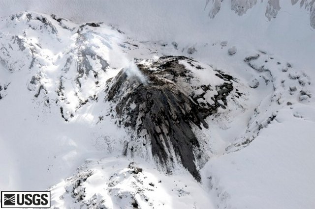 |
Figure 61. High-angle view of Mount St. Helens new dome from the NNW, taken on 5 February 2006 by John Pallister. Photograph courtesy of USGS. |
Gas measurements made on 15 February suggested that the volcanic-gas flux remained unchanged from recent measurements. Observations made on 17 February revealed that the active NE part of the new lava dome was developing a steeply inclined jagged spine. At its top, temperatures as high as 580°C were measured using a thermal sensor.
Growth of the new lava dome inside the crater of Mount St. Helens continued during March, April, and May 2006, accompanied by low rates of seismicity, low emissions of steam and volcanic gases, and minor production of ash. Small earthquakes occurred every several minutes, punctuated by occasional larger earthquakes. The Global Positioning System (GPS) receiver on the new lava dome showed that lava emerging from the vent was still advancing WNW at about a meter per day. Small rockfalls produced small ash clouds that rose from the dome's NW flank. The eruption of lava into the crater continued, shown by ongoing rockfalls and continuous GPS measurements made on the growing lava lobe.
Analysis of photographs revealed that a slab of rock approximately 50,000 cubic meters in volume was shed from the N margin of the growing spine during 6-7 May. This probably coincided with a large seismic signal recorded on the night of 7 May. Rock-avalanche deposits extended a few hundred meters to the NE. The avalanche was accompanied by an ash cloud. The spine continued to grow during 10-15 May, producing rockfalls that intensified on the evening of 14 May. Incandescence was visible on satellite imagery. On 17 May night-time incandescence from rockfalls was observed.
During 24-25 May, seismicity was at levels typical of the continuing lava-dome extrusion at Mount St. Helens. On 29 May, a M 3.1 earthquake and simultaneous large rockfall occurred. An ash plume produced at 0810 reached an altitude of 4.9 km - 6.1 km according to ground observations and pilot reports (figure 62). One pilot report suggested that the plume reached an altitude of 7.3 km. By 1308, ash from the event was no longer visible on satellite imagery. The rockfall originated primarily from the N side of the growing fin (figures 63 and 64).
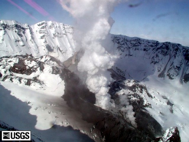 |
Figure 62. At Mt. St. Helens, a view from the Brutus camera at 0914 on 29 May 2006. Vapor with light ash obscures most of the extruding lava spine. The light gray swath in the center of the photograph shows the path of the rock avalanche as it flowed downhill. The dark areas adjacent to the rock-avalanche path shows the ash cloud (finer material) that accompanied the avalanche. Photograph courtesy USGS. |
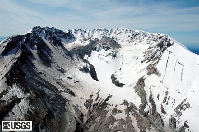 |
Figure 63. Mount St. Helens crater and dome showing aftermath of rockfall event of 29 May 2006, seen from the N. Taken on 30 May 2006 by Willie Scott and Jim Vallance. Photograph courtesy USGS. |
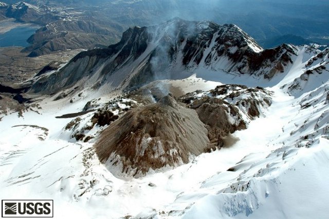 |
Figure 64. Aerial view showing Mount St. Helens crater and dome as seen from the SW. Spirit Lake can just be seen in the upper right corner. Taken on 30 May 2006 by Willie Scott and Jim Vallance. Photograph courtesy USGS. |
During June 2006, seismicity indicated that the lava spine continued to grow inside the crater of Mount St. Helens and occasionally produced minor rockfalls. On 9 June, pilots reported that an ash-and-steam plume, generated after a rockfall following a M 3.2 earthquake, reached an altitude of 4.6 km. According to seismic data, a medium-sized rockfall occurred on 13 June. Incandescence was observed on satellite imagery. A small steam plume from the lava dome and dust from minor rockfalls were visible from the US Forest Service's web camera at the Johnston Ridge Observatory on 25 and 26 June. On 26 June, a pilot reported that dust and ash reached an altitude of ~ 2.4 km and drifted W.
From January through June 2006, St Helens remained at Volcano Advisory (Alert Level 2); aviation color code Orange.
Geological Summary. Prior to 1980, Mount St. Helens was a conical volcano sometimes known as the Fujisan of America. During the 1980 eruption the upper 400 m of the summit was removed by slope failure, leaving a 2 x 3.5 km breached crater now partially filled by a lava dome. There have been nine major eruptive periods beginning about 40-50,000 years ago, and it has been the most active volcano in the Cascade Range during the Holocene. Prior to 2,200 years ago, tephra, lava domes, and pyroclastic flows were erupted, forming the older edifice, but few lava flows extended beyond the base of the volcano. The modern edifice consists of basaltic as well as andesitic and dacitic products from summit and flank vents. Eruptions in the 19th century originated from the Goat Rocks area on the N flank, and were witnessed by early settlers.
Information Contacts: Cascades Volcano Observatory (CVO), U.S. Geological Survey, 1300 SE Cardinal Court, Building 10, Suite 100, Vancouver, WA 98683-9589, USA (URL: https://volcanoes.usgs.gov/observatories/cvo/).