Report on Karthala (Comoros) — June 2006

Bulletin of the Global Volcanism Network, vol. 31, no. 6 (June 2006)
Managing Editor: Richard Wunderman.
Karthala (Comoros) Eruptions in May and July 2006
Please cite this report as:
Global Volcanism Program, 2006. Report on Karthala (Comoros) (Wunderman, R., ed.). Bulletin of the Global Volcanism Network, 31:6. Smithsonian Institution. https://doi.org/10.5479/si.GVP.BGVN200606-233010
Karthala
Comoros
11.75°S, 43.38°E; summit elev. 2361 m
All times are local (unless otherwise noted)
Karthala generated two strong eruptions in 2005 (BGVN 31:01). This report, based on information from Kashkazi (a newspaper in the Comores), discusses the interval May to late July 2006.Kashkazi reported that a magmatic eruption on 28 May occurred inside the Chahalé caldera. Lava fountains were seen inside the lava lake. No lava flow was observed outside the caldera. Some bubbling continued in the crater lake through 31 May (figure 24), but the surface on the SE part had solidified.
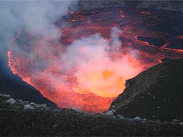 |
Figure 24. The lava lake in Karthala's Chahalé caldera, 31 May 2006. The lava lake's surface contained both a churning zone of degassing lava (right center) and a larger adjacent zone largely composed of cooled floating crust. Photo by Julie Morin. |
The news media reported several other events that occurred by the afternoon of 1 June. The lava lake had completely crusted over. Seismicity had returned to background levels. Some gas and ash was released.
According to available sources, the volcano was relatively quiet until a brief 16-18 July eruption. In that eruption a lava lake again formed in the crater and ash was discharged.
A UN official stated in an IRINnew.org article, ". . . contamination of the water supply raises serious concerns about the availability of potable water in the areas exposed to smoke and ash." As of 22 July, about 2,000 people had evacuated and 123,000 people lacked clean water supplies.
Geological Summary. The southernmost and largest of the two shield volcanoes forming Grand Comore Island (also known as Ngazidja Island), Karthala contains a 3 x 4 km summit caldera generated by repeated collapse. Elongated rift zones extend to the NNW and SE from the summit of the Hawaiian-style basaltic shield, which has an asymmetrical profile that is steeper to the S. The lower SE rift zone forms the Massif du Badjini, a peninsula at the SE tip of the island. Historical eruptions have modified the morphology of the compound, irregular summit caldera. More than twenty eruptions have been recorded since the 19th century from the summit caldera and vents on the N and S flanks. Many lava flows have reached the sea on both sides of the island. An 1860 lava flow from the summit caldera traveled ~13 km to the NW, reaching the W coast to the N of the capital city of Moroni.
Information Contacts: IRINnews.org, United Nations, Office for the Coordination of Humanitarian Affairs (URL: http://www.irinnews.org/); Kashkazi.