Report on Piton de la Fournaise (France) — June 2006

Bulletin of the Global Volcanism Network, vol. 31, no. 6 (June 2006)
Managing Editor: Richard Wunderman.
Piton de la Fournaise (France) Eruption on 20 July 2006 after months of seismicity
Please cite this report as:
Global Volcanism Program, 2006. Report on Piton de la Fournaise (France) (Wunderman, R., ed.). Bulletin of the Global Volcanism Network, 31:6. Smithsonian Institution. https://doi.org/10.5479/si.GVP.BGVN200606-233020
Piton de la Fournaise
France
21.244°S, 55.708°E; summit elev. 2632 m
All times are local (unless otherwise noted)
Piton de la Fournaise exhibited dynamic activity in February and October-December 2005 (BGVN 30:11). This report covers January to July 2006. According to the Observatoire Volcanologique du Piton de la Fournaise (OVPF), following the 2005 activity was an eruptive period during 3-18 January 2006. During this time there were lava flows leaving the Plain of Osmondes and descending into the Grandes Pentes.
Seismicity was low from mid-January through March. From March until mid-July, seismicity gradually increased (figure 73), reaching 80 earthquakes on 2 July. From 1 March to the end of June, instruments detected up to 5 cm of horizontal movement at many stations (figure 74).
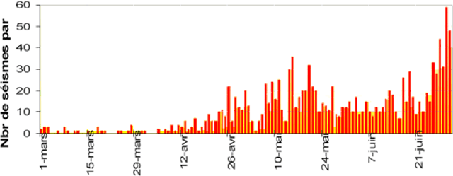 |
Figure 73. Daily earthquakes at Piton de la Fournaise during 1 March to 1 July 2006. Courtesy of OVPF. |
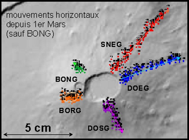 |
Figure 74. Plot of the horizontal movement of Piton de la Fournaise's stations from 1 March to the end of June 2006. All of the stations had moved horizontally except for BONG, which had shifted in a circular motion during the months of observation. Station SNEG had the greatest horizontal shift, up to 5 cm. Courtesy of OVPF. |
Although there was a decrease in seismicity on 17 July, on 20 July at 0218 seismicity spiked. At 0400, the summit began erupting (figure 75). A 50-m-long fissure opened on the SW flank and a lava flow went E of Rivals crater. A second 50-m-long fissure opened on the S flank between Rivals and Fort Chateau craters.
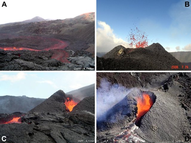 |
Figure 75. Lava flows and eruptive processes at Piton de la Fournaise, July 2006. The scanty available information about the photos is discussed below. a) Lava flow on the morning of 20 July 2006, the first day of the eruption; courtesy of A. Peltier, OVPF. b) Spattering cone on 24 July 2006; courtesy of T. Staudacher, OVPF. c) Cone at the main vent on the morning of 25 July 2006; courtesy of A. Peltier, OVPF. d) Erupting cone (date undisclosed); courtesy of Serge Gelabert. |
On 24 July a small pyroclastic cone formed and lava fountains were visible (figure 75). One lava flow destroyed a new seismic station near Fort Chateau. On 31 July, a 200-m-long lava flow was visible S of the erupting cone. The eruption continued through the end of July. Figure 75 presents a series of photos from the eruption.
Geological Summary. Piton de la Fournaise is a massive basaltic shield volcano on the French island of Réunion in the western Indian Ocean. Much of its more than 530,000-year history overlapped with eruptions of the deeply dissected Piton des Neiges shield volcano to the NW. Three scarps formed at about 250,000, 65,000, and less than 5,000 years ago by progressive eastward slumping, leaving caldera-sized embayments open to the E and SE. Numerous pyroclastic cones are present on the floor of the scarps and their outer flanks. Most recorded eruptions have originated from the summit and flanks of Dolomieu, a 400-m-high lava shield that has grown within the youngest scarp, which is about 9 km wide and about 13 km from the western wall to the ocean on the E side. More than 150 eruptions, most of which have produced fluid basaltic lava flows, have occurred since the 17th century. Only six eruptions, in 1708, 1774, 1776, 1800, 1977, and 1986, have originated from fissures outside the scarps.
Information Contacts: Observatoire Volcanologique du Piton de la Fournaise (OVPF), Institut de Physique du Globe de Paris, 14 route nationale 3, 27 ème km, 97418 La Plaine des Cafres, La Réunion, France (URL: http://www.ipgp.fr/fr/ovpf/observatoire-volcanologique-piton-de-fournaise); Serge Gélabert, 85, rue juliette Dodu, 97400 Saint-Denis, Ile de La Réunion.