Report on Karthala (Comoros) — July 2006

Bulletin of the Global Volcanism Network, vol. 31, no. 7 (July 2006)
Managing Editor: Richard Wunderman.
Karthala (Comoros) Seismic crisis on 28 May 2006 precedes lava lake eruption in Chahalé crater
Please cite this report as:
Global Volcanism Program, 2006. Report on Karthala (Comoros) (Wunderman, R., ed.). Bulletin of the Global Volcanism Network, 31:7. Smithsonian Institution. https://doi.org/10.5479/si.GVP.BGVN200607-233010
Karthala
Comoros
11.75°S, 43.38°E; summit elev. 2361 m
All times are local (unless otherwise noted)
On 28 May 2006, a magmatic eruption occurred inside the Chahalé caldera of Karthala volcano. Information in the previous report (BGVN 31:06) was based on newspaper accounts. This report comes from Hamidou Nassor, Julie Morin, Christopher Gomez, Magali Smietana, François Sauvestre, and Christopher Gomez. They noted some key references relating to Karthala, including a 2001 dissertation (Bachèlery and others, 1995; Krafft, 1982; and Nassor, 2001).
The 28 May 2006 crisis began with a few hours of elevated seismic activity, beginning around 1230 (local time). Three hours later, seismic stations recorded a small crisis that lasted for 6 hours and produced both SP and LP signals. Around 2107 the magmatic eruption began. Seismographs recorded a tremor only a few seconds later.
From the coast of the island a red cloud was visible above the volcano. Scientists at the Karthala observatory met with government representatives and confirmed a magmatic eruption. It was not yet known if the eruption had occurred on the caldera floor or inside the main crater. A trip to the volcano was necessary in order to assess the volcanic activity and determine the exact location of the eruption. Two hypotheses were proposed: (1) If the eruption was located in the N part of the caldera, the lava could flow outside the caldera, towards populated areas; (2) If the eruption was located inside the main crater, to the S, lava would remain inside the crater. The Comorian authorities helped the scientific team to get assistance from the South African Army (AMISEC) to fly over the volcano.
On the morning of 29 May 2006, the scientific team and AMISEC personnel flew over the volcano. They saw that the eruption was contained inside the main (Chahalé) crater, where the past three eruptions had occurred. A lava fountain was observed in the middle of the lava lake (figure 25). No lava flow was observed outside the caldera. Seismic records showed a tremor caused by the lava fountain; the fountain was apparently spurting since the beginning of the eruption.
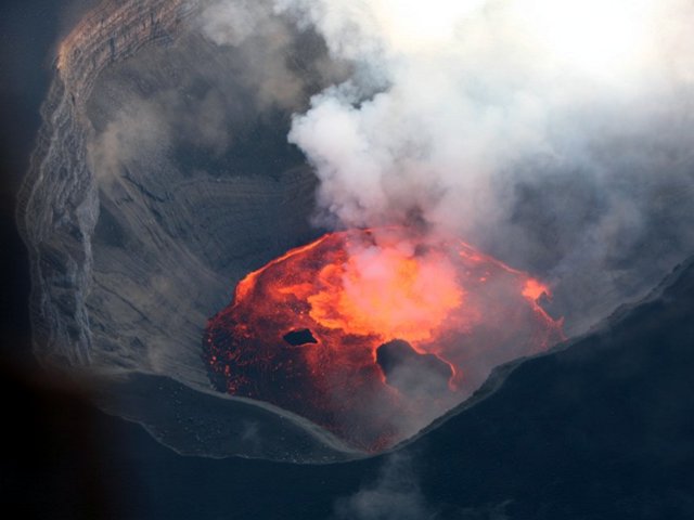 |
Figure 25. This lava lake was seen in the main crater, Chahalé, on 29 May. The lava fountain was in the N part of the lake. Some lava blocks larger than 1 m in diameter are visible. The gas and vapor plume reached an altitude of about 3 km. Photo courtesy of Julie Morin. |
On the morning of 31 May, the scientific team returned to Karthala with AMISEC forces. Part of the lake was still mobile and bubbling, but part had solidified on the surface in the SE and a few blocks were floating on the side of the lake (figure 26). No projectiles overshot the caldera rim.
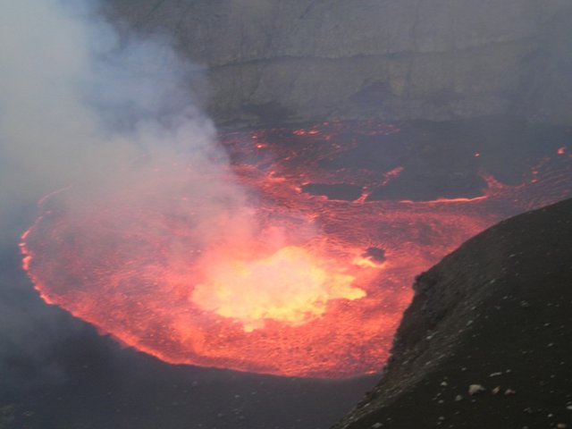 |
Figure 26. Karthala's lava lake on 31 May. In the lake's NW, a lava fountain was active, while the lake's S part had started to solidify. Photo courtesy of Magali Smietana. |
On 1 June 2006 seismic monitoring indicated the end of the tremor phase. On 2 June scientists returned to the summit with AMISEC forces. They observed that the surface of the lava lake was solidified, but the deeper portions of the lake remained hot (figure 27).
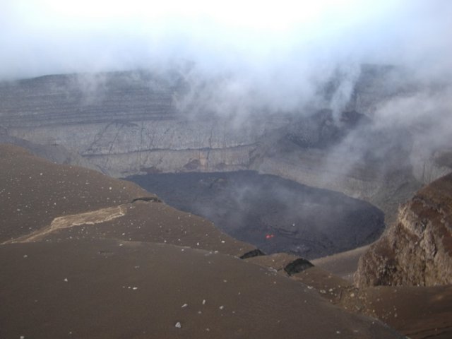 |
Figure 27. The floor of Karthala's Chahalé crater remained filled by lava on 2 June, although a crust had formed covering much of the lava lake. Photo courtesy of Christopher Gomez. |
References. Bachèlery, P., Damir, B.A., Desgrolard, F., Toutain, J.P, Coudray, J.P., Cheminée, J-L., Delmond, J.C., and Klein, J.L. 1995, L'éruption phréatique du Karthala (Grande Comore) en juillet 1991: C.R Acad. Sci. Paris, 320, série Iia, p. 691-698.
Krafft, M., 1982, L'éruption volcanique du Karthala en avril 1977 (Grande Comore, Océan Indien): C.R. Acad. Sci. Paris, t 294, série II, p. 753-758.
Nassor, H., 2001, Contribution ? l'étude du risque volcanique sur les grands volcans boucliers basaltiques: le Karthala et le Piton de la Fournaise: Ph.D. thesis, Univ. Reunion.
Geological Summary. The southernmost and largest of the two shield volcanoes forming Grand Comore Island (also known as Ngazidja Island), Karthala contains a 3 x 4 km summit caldera generated by repeated collapse. Elongated rift zones extend to the NNW and SE from the summit of the Hawaiian-style basaltic shield, which has an asymmetrical profile that is steeper to the S. The lower SE rift zone forms the Massif du Badjini, a peninsula at the SE tip of the island. Historical eruptions have modified the morphology of the compound, irregular summit caldera. More than twenty eruptions have been recorded since the 19th century from the summit caldera and vents on the N and S flanks. Many lava flows have reached the sea on both sides of the island. An 1860 lava flow from the summit caldera traveled ~13 km to the NW, reaching the W coast to the N of the capital city of Moroni.
Information Contacts: Hamidou Nassor (LSTUR) Université de la Réunion BP 7151, 15 Avenue, René Cassin, 97715 Saint-Denis; Julie Morin; Christopher Gomez, Laboratoire de géographie physique CNRS LGP; Magali Smietana, Universite de Rennes 1, France; Francois Sauvestre (CNDRS), BP 169, Moroni (URL: http://volcano.ipgp.jussieu.fr/karthala/stationkar.html).