Report on St. Helens (United States) — July 2006

Bulletin of the Global Volcanism Network, vol. 31, no. 7 (July 2006)
Managing Editor: Richard Wunderman.
St. Helens (United States) Eruption still extrudes dacitic dome lavas without energetic explosions
Please cite this report as:
Global Volcanism Program, 2006. Report on St. Helens (United States) (Wunderman, R., ed.). Bulletin of the Global Volcanism Network, 31:7. Smithsonian Institution. https://doi.org/10.5479/si.GVP.BGVN200607-321050
St. Helens
United States
46.2°N, 122.18°W; summit elev. 2549 m
All times are local (unless otherwise noted)
The current and ongoing eruption of the St. Helens started on 11 October 2004. Extrusion of the growing lava dome has continued in the same quiescent mode exhibited over the past year, and levels of seismicity remained generally low, with low emissions of steam and volcanic gases and minor production of ash. From 1830 hours on 26 October 2004 to 15 August 2006, a total of 13,841 seismic triggers have occurred. Figures 65 and 66 summarize seismicity over the past year. A decade-long time-depth plot clearly shows the start of the current eruption (figure 67).
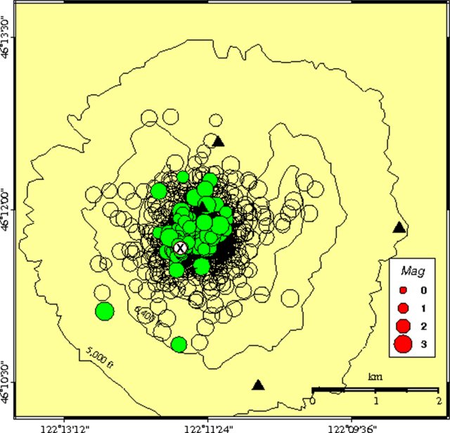 |
Figure 65. Epicenters of St. Helens earthquakes between 1 July 2005 and 15 August 2006, a total of 1,768 well-located earthquakes. The circle with an "x" represents events on 15 August 2006, and filled circles represent events since 15 July 2006; open circles represent older events in the past year. Black triangles locate Pacific Northwest Seismograph Network (PNSN) seismic stations. Courtesy of the PNSN. |
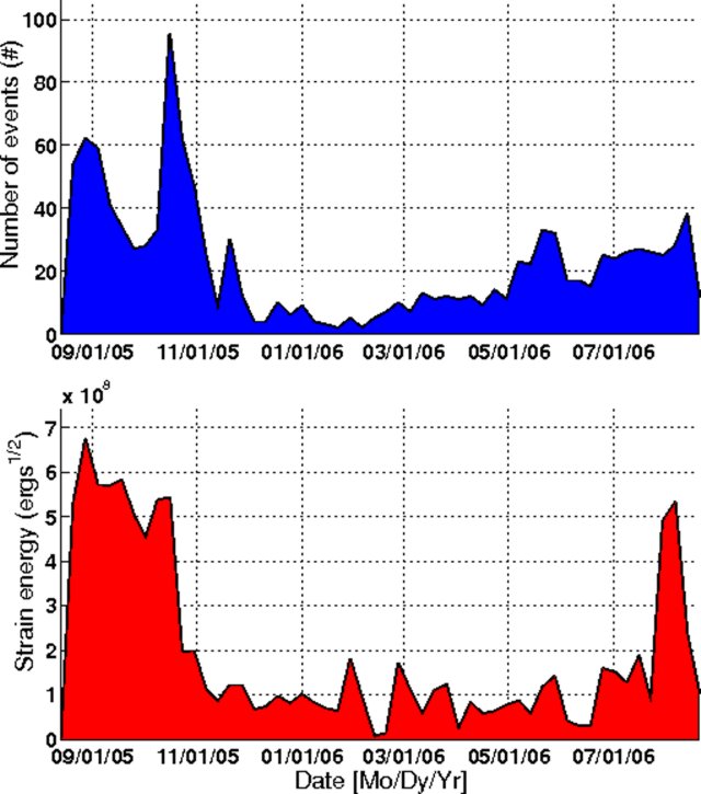 |
Figure 66. Plots of the number of well-located events and their main root of strain energy for St. Helens earthquakes between 1 July 2005 and 15 August 2006 describing a total of 1,768 earthquakes. Each point on the strain energy plot's curve represents the sum of energy released by all earthquakes in a 14-day period; energy is computed in 14-day time windows, every 7 days. Courtesy of the PNSN. |
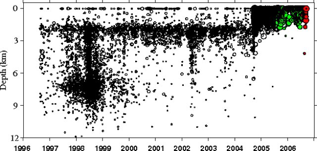 |
Figure 67. Time-depth plot of well-located earthquakes at St. Helens between 1996 and 14 September 2006, a total of 22,485 events. Courtesy of the PNSN. |
Pictures and movies taken in August 2006 with the Brutus camera (located on the E rim of the 1980 Mount St. Helens crater) showed continued extrusion of spine 7 on the growing lava dome (figure 68) (photos and movies are also available on the CVO website). Between 4-5 and 7-8 August a segment of the middle part of spine 7 temporarily stopped moving. At 1310 on 5 August a magnitude 3.6 earthquake occurred, and subsequent photographs showed that the "stuck" segment became unstuck. Motion again stopped sometime after 1310 on 7 August and much of 8 August, when a M 3.3 earthquake occurred at 2001 on 8 August. Clouds obscured the volcano from view on 9 August, but parted enough on 10 August to show that once again the segment became unstuck. One explanation by CVO scientists for these observations is that the large earthquakes were caused by parts of the spine sticking and then slipping.
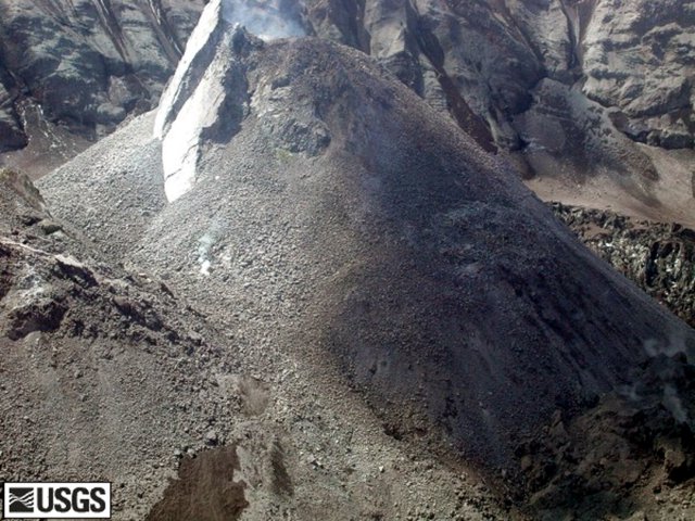 |
Figure 68. Spine 7 of the growing lava dome of Mount St. Helens taken 3 August 2006. Courtesy of CVO. |
Geological Summary. Prior to 1980, Mount St. Helens was a conical volcano sometimes known as the Fujisan of America. During the 1980 eruption the upper 400 m of the summit was removed by slope failure, leaving a 2 x 3.5 km breached crater now partially filled by a lava dome. There have been nine major eruptive periods beginning about 40-50,000 years ago, and it has been the most active volcano in the Cascade Range during the Holocene. Prior to 2,200 years ago, tephra, lava domes, and pyroclastic flows were erupted, forming the older edifice, but few lava flows extended beyond the base of the volcano. The modern edifice consists of basaltic as well as andesitic and dacitic products from summit and flank vents. Eruptions in the 19th century originated from the Goat Rocks area on the N flank, and were witnessed by early settlers.
Information Contacts: U.S. Geological Survey Cascades Volcano Observatory, Vancouver, WA (URL: https://volcanoes.usgs.gov/observatories/cvo/); The Pacific Northwest Seismograph Network, University of Washington Dept. of Earth and Space Sciences, Box 351310, Seattle, WA (URL: http://www.geophys.washington.edu/SEIS/PNSN/).