Report on Kilauea (United States) — August 2006

Bulletin of the Global Volcanism Network, vol. 31, no. 8 (August 2006)
Managing Editor: Richard Wunderman.
Kilauea (United States) Lava entering the sea at E Lae`apuki; small bench collapse on 30 July 2006
Please cite this report as:
Global Volcanism Program, 2006. Report on Kilauea (United States) (Wunderman, R., ed.). Bulletin of the Global Volcanism Network, 31:8. Smithsonian Institution. https://doi.org/10.5479/si.GVP.BGVN200608-332010
Kilauea
United States
19.421°N, 155.287°W; summit elev. 1222 m
All times are local (unless otherwise noted)
Much of the activity at Kīlauea has remained the same since last reported in BGVN 31:04. This report covers the time interval 8 February through most of July 2006. Lava continued to enter the sea at the East Lae`apuki area with volcanic tremor near normal background levels at Kīlauea's summit. Numerous shallow earthquakes continued to occur at the summit and upper E rift zone. Volcanic tremor reached moderate levels at Pu`u `O`o. Slow, steady inflation continued at Kīlauea's summit as it has more or less since mid-January 2006. A 4-hectare (10 acre) bench collapse occurred 30 July 2006 (figure 178).
 |
Figure 178. An aerial view of the E Lae`apuki entry at Kīlauea showing the area of the 30 July bench collapse. A four-hectare chunk of the W side of the bench broke off and fell into the water. The black line marks approximate edge of the bench before the collapse. Courtesy of USGS-HVO. |
Beginning on 8 February, surface lava flows were not visible on the Pulama pali scarp due to lava traveling underground through the PKK lava tube.
On 1 March, lava emerged from the PKK lava tube at elevations between 45 and 75 m, and proceeded in lava streams extending 200-400 m to the coast. The lava streams continued to flow off of the lava delta and into the ocean throughout this reporting period.
Inflation on 16 May was accompanied by an abrupt drop in volcanic tremor at Kīlauea's summit. Volcanic tremor reached moderate levels at Pu`u `O`o. Small lava flows were visible on 19 May and minor incandescence was observed on 21-22 May at Kīlauea's East Lae`apuki lava delta. Incandescence was visible from East Pond vent, January vent, and Drainhole during 24-30 May, and from the South Wall complex on 24 and 30 May and throughout June.
On 24 June, lava that flowed over a sea cliff was fed from a breakout point about 50 m inland from the cliff. The area of East Lae`apuki lava delta was estimated to be approximately 21 hectares (52 acres). The floor of Drainhole vent in Pu`u `O`o's crater collapsed and produced a 30 x 25 m lava pond with dynamically active lava on the SE side of the pit. Lava from the Campout flow and tube, located on the E margin of the PKK shield, advanced 1.2 km towards the Pulama pali during about 19-24 June.
On 30 June, surface lava flows originating from the Campout lava tube were visible on the upper part of the Pulama pali fault scarp, which had not been seen since 8 February. Incandescence was visible from Drainhole vent in Pu`u `O`o's crater and tremor remained at moderate level at Pu`u `O`o. By the end of July, the Campout flow was ~ 1.7 km from the sea at Ka`ili`ili, about 440 m from the observed terminus on 14 July.
A 4-hectare (10-acre) area of the lava delta at Kīlauea's East Lae`apuki collapsed into the ocean at 1247 on 30 July. The collapse represented less than 15% of the delta's total area (figures 178 and 179). During the collapse, explosive activity bombarded the older lava delta and sea cliff on the western side of the bench, sending spatter and rock debris up to about 40 m inland—nearly half the distance to the rope barricade.
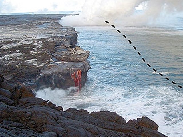 |
Figure 179. A view of the East Lae`apuki bench from the W photographed at unstated date and published on 4 August 2006. The dashed line shows the approximate seaward extent of the area lost to the bench collapse on 30 July 2006. Photo courtesy of Greg Santos, Honolulu Advertiser. |
During 2-8 August, lava from the PKK lava tube flowed into the ocean at two entries on the SE flank, East Lae`apuki and about 3.5 km E at East Ka`ili`ili. Tilt at the Pu`u `O`o cone displayed a saw-tooth pattern and tremor remained at a moderate level. A leveling survey revealed an inflationary trend at the summit of Kīlauea, in areas S of Halema`uma`u crater. Elevations have increased 11 cm in the past 6 months and continued to increase during the reporting period.
Geological Summary. Kilauea overlaps the E flank of the massive Mauna Loa shield volcano in the island of Hawaii. Eruptions are prominent in Polynesian legends; written documentation since 1820 records frequent summit and flank lava flow eruptions interspersed with periods of long-term lava lake activity at Halemaumau crater in the summit caldera until 1924. The 3 x 5 km caldera was formed in several stages about 1,500 years ago and during the 18th century; eruptions have also originated from the lengthy East and Southwest rift zones, which extend to the ocean in both directions. About 90% of the surface of the basaltic shield volcano is formed of lava flows less than about 1,100 years old; 70% of the surface is younger than 600 years. The long-term eruption from the East rift zone between 1983 and 2018 produced lava flows covering more than 100 km2, destroyed hundreds of houses, and added new coastline.
Information Contacts: Hawaiian Volcano Observatory (HVO), U.S. Geological Survey, PO Box 51, Hawaii National Park, HI 96718, USA (URL: https://volcanoes.usgs.gov/observatories/hvo/); Honolulu Advertiser (URL: http://the.honoluluadvertiser.com/).