Report on Rabaul (Papua New Guinea) — September 2006

Bulletin of the Global Volcanism Network, vol. 31, no. 9 (September 2006)
Managing Editor: Richard Wunderman.
Rabaul (Papua New Guinea) Strong eruption at Tavurvur ejected ash and large plumes to the troposphere
Please cite this report as:
Global Volcanism Program, 2006. Report on Rabaul (Papua New Guinea) (Wunderman, R., ed.). Bulletin of the Global Volcanism Network, 31:9. Smithsonian Institution. https://doi.org/10.5479/si.GVP.BGVN200609-252140
Rabaul
Papua New Guinea
4.2459°S, 152.1937°E; summit elev. 688 m
All times are local (unless otherwise noted)
A 7 October Rabaul eruption obscured visibility in and around the caldera, which sits at the NE end of New Britain Island (figure 42). The eruption took place at the intra-caldera cone Tavurvur, and emissions included lava flows. Intermittent eruptions had occurred at Tavurvur since 1994, the last of which took place on 15 January 2006 (BGVN 31:02). Photos by pilots shortly after the eruption documented a dramatic umbrella-shaped plume, which rose to the tropopause and created an SO2 cloud that later divided into two parts, one moving NW, the other SE.
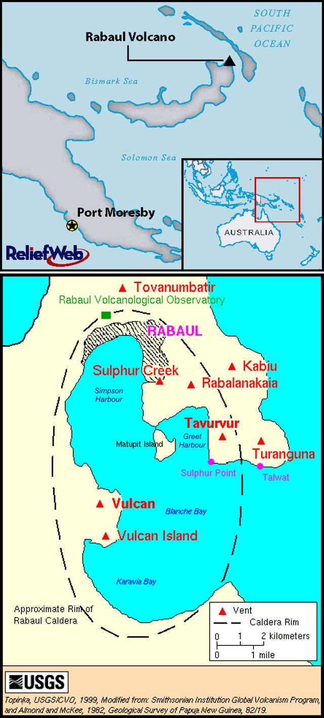 |
Figure 42. (Top) Index maps indicating the location and geography around Rabaul caldera. (Bottom) A map of Rabaul derived from work by Almond and McKee and prepared by Lyn Topinka (US Geological Survey). For other maps see previous Bulletin reports on Rabaul (most recently, BGVN 28:01). |
Rabaul Volcano Observatory (RVO) observations. The RVO announced that a sustained eruption from Tavurvur did not appear to have been any immediate precursors apart from a small deflation. The sub-Plinian eruption began at about 0845 on 7 October 2006 and continued into the early afternoon. Semi-continuous to rhythmic air blasts were obvious in Rabaul town, with doors slamming and windows rattling. Rabaul received moderately heavy ashfall; heavy lapilli of ~1 mm diameter fell, and a few lithics up to 3 cm across fell around the S and SW parts of the caldera. According to Herman Patia at RVO, a small pumice raft accumulated in Greet Harbor and pumice was still drifting about several weeks later.
Ashfall affected the whole of the Gazelle peninsula (the name given to the bulbous, 50-km-diameter NE end of New Britain island). About 1 cm of ash was deposited on the SW side of the caldera in the Blue Lagoon-Vulcan sector. Ashfall occurred ~ 7 km SE of Rabaul caldera's center point in Kokopo and -20 km S of the center point in Warangoi. The density of ashfall was such that Tavurvur was obscured from all directions. In the town of Rabaul the experience was very similar to the October 1996 and January 1997 Strombolian eruptions.
At 1200 on 7 October 2006 the RSAM was about 1900 units and its rate appeared to be decreasing. (The Real-time Seismic Amplitude is an often-used tool to summarize seismic activity during volcanic crises by presenting a measure of the average amplitude of ground shaking over successive 10-min intervals.) Thick ash clouds rose to a height of about 18 km. The cloud subsequently dispersed over a broad western swath (N to W to S). The nature of the eruption changed to Strombolian at 1415 hours, with activity characterized by frequent explosions accompanied by shock waves. At 1730 hours, the Strombolian activity began to subside. A moderate to bright glow was visible during the evening of 7 October on Tavurvur's N rim, accompanied by occasional explosions and loud roaring noises throughout the night.
In the morning of 8 October, thick white and blue vapor accompanied occasional ash explosions drifted N and NW of Tavurvur. Inspection from Rapindik (2 km NNW from Tavurvur) revealed lava flows emplaced down the cone's W and N flanks. The W flank flow went into the harbor and caused small secondary explosions; visibility of the N flank was poor due to the white vapor emission. The RSAM level decreased to the background value of ~70 units.
Herman Patia reported that by 28 October 2006 the eruption had quieted down with only occasional ash emission accompanied by rare explosions. Seismic activity was at a low level and ground deformation was at a low rate. On 30 October mild eruptive activity continued at Tavurvur. The activity consisted of continuous emission of thick pale to dark gray ash clouds that drifted N to NW of the volcano. Fine ash fall occurred in the NE caldera at Namanula, and also in surrounding areas downwind and on the E side of Rabaul Town. There were no audible noises and no glow visible. The low-level eruptive activity consisted of occasional ash emissions similar to those that have occurred regularly since 1994.
Pilot observations. Figures 43 and 44 are pilot's photographs provided by Tony Gridley, Air Niugini, indicating the well-developed ash clouds visible 1-2 hours after the eruption. The photos are reminiscent of the 20 September 1994 photo of the eruption cloud taken from the orbiting Space Shuttle, an oblique, downward-looking perspective from the NE about 24 hours after the start of that eruption (BGVN 19:08).
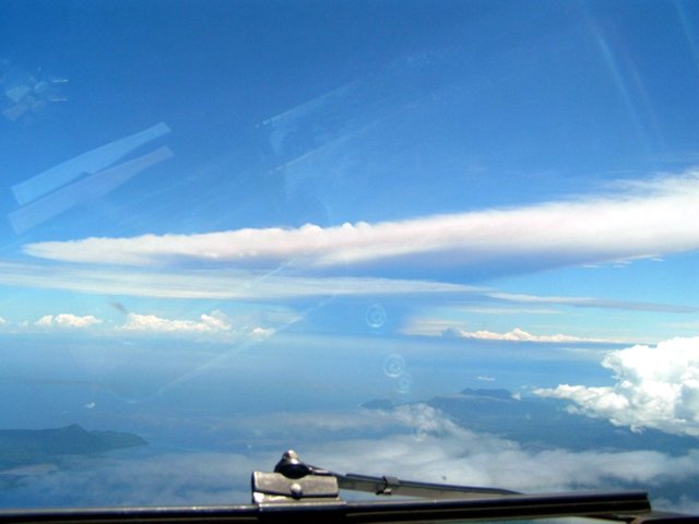 |
Figure 43. Aerial photo taken 1 or 2 hours after the eruption of 7 October 2006 at ~3.7 km (~12,000 ft) and ~90 km (~50 nautical miles) from Tokua airport (Rabaul's new airport, on the S side of the caldera) while flying at a heading of about 060° (i.e. looking ENE). The flight was "on the Hoskins-Tokua track." Courtesy of Tony Gridley, Air Niugini. |
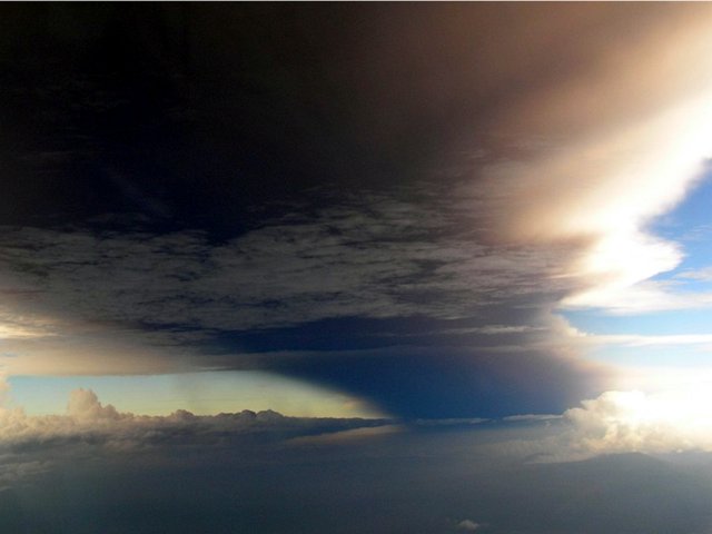 |
Figure 44. Aerial photo taken 1 or 2 hours after the eruption of 7 October 2006 at ~3.7 km (~12,000 ft) and ~90 km from Tokua airport, heading about 060°. Courtesy of Tony Gridley, Air Niugini. |
Satellite observations. According to Andrew Tupper, the 7 October eruption was clearly visible on infrared and visible imagery (to around tropopause altitudes). Figure 45 shows the ash cloud imaged from the MODIS satellite on 7 October 2006. Figure 46 depicts the sulfur dioxide (SO2) in Dobson Units (DU) from the Ozone Monitoring Instrument (OMI) for 7-9 October 2006. Further details appear in the figure caption. The SO2 concentration-pathlengths on the figure are shown using the logarithmic scale of Dobson Units. (As one explanation of this unit, if all SO2 in the air column the satellite observed was flattened into a thin layer at the surface of the Earth at a temperature of 0°C, then 1 Dobson Unit would make a layer of pure SO2 0.01 mm thick.)
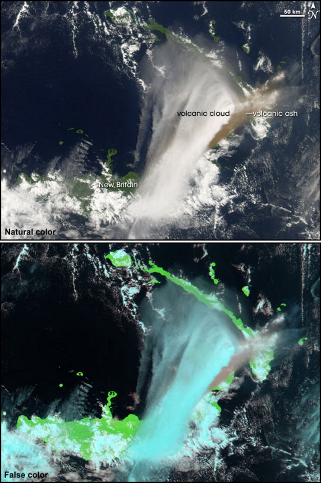 |
Figure 45. True-color (above) and false-color (below) images of a Rabaul eruption cloud created by the Moderate Resolution Imaging Spectroradiometer (MODIS) on NASA's Aqua satellite, 7 October 2006. Volcanic emissions block the view of most of the island but Rabaul's approximate location is at the solid triangle. The brown or tan plume in the E clearly bears volcanic ash. The bright "cloud" to the immediate left of the brown ash represents a portion of the volcanic ash plume that reached a high enough altitude for the water content of that plume to turn to ice crystals that "white out" the ash content that would otherwise appear tan or brown. Courtesy of the NASA Earth Observatory. |
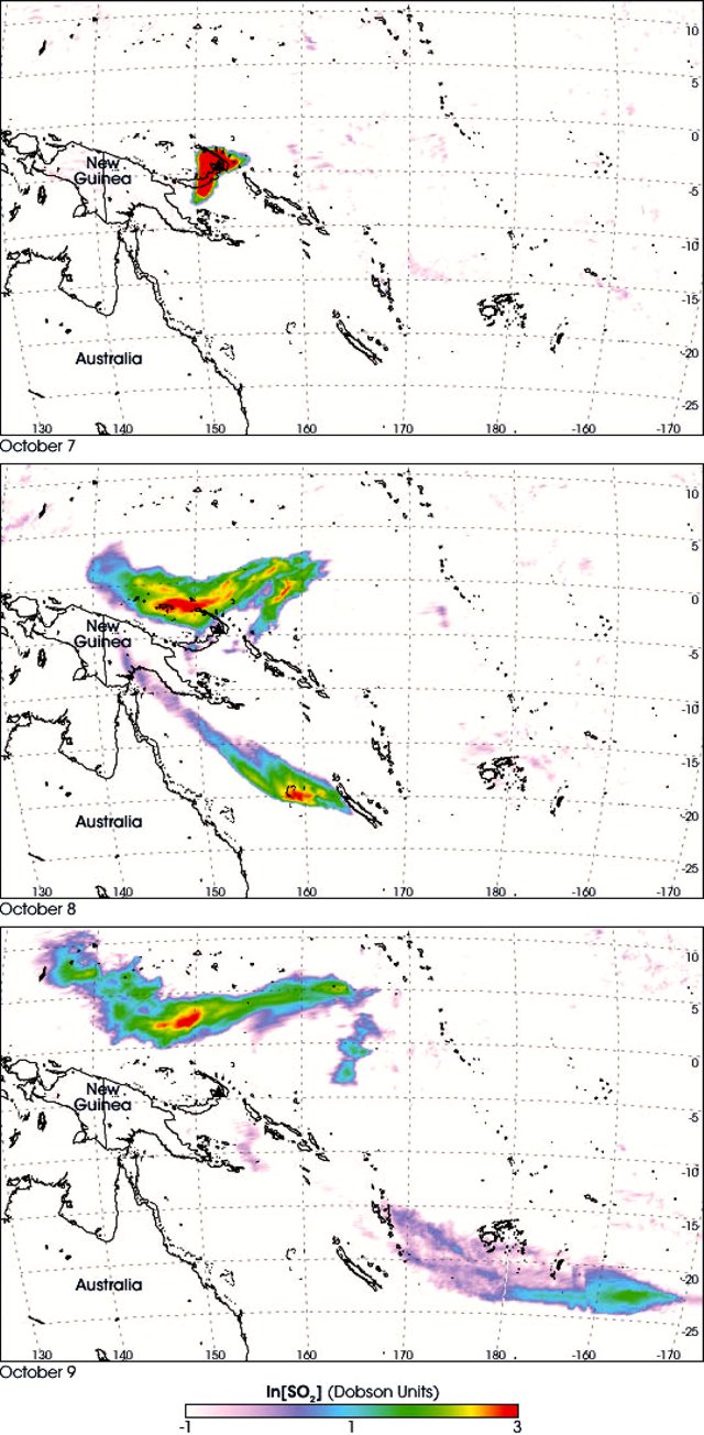 |
Figure 46. The Rabaul eruption injected SO2 into the atmosphere and measurements from satellite spectrometers led to creation of this series of images mapping the SO2 concentrations over the region during 7-9 October 2006. Data are from the Ozone Monitoring Instrument on NASA's Aura satellite. On 7 October, high SO2 concentrations lingered over New Britain. By 8 October, the original plume had split into two clouds, one spreading NW, the other, SE. On 9 October, the SO2 had diffused more, but a core of elevated concentration-pathlength values remained in the northern plume. Courtesy of NASA Earth Observatory and Simon Carn, University of Maryland Baltimore County. |
Based on information from the RVO, the Darwin VAAC reported that a brief eruption of Rabaul on 11 October produced a plume that reached an altitude of 7.6 km altitude and dissipated NW. Continuous low-level emissions and vulcanian eruptions produced plumes to 1 km altitude during 12-17 October.
Moderate Resolution Infrared Spectroradiometry (MODIS) thermal anomalies. Table 4 shows the thermal anomalies as measured from the MODIS satellite during the eruption period. Note that there were no anomalies for several months before this period. The anomalies are in harmony with the observed lava flows.
Table 4. MODIS thermal anomalies for Rabaul volcano for 7-17 October 2006. Courtesy of Hawai'i Institute of Geophysics and Planetology.
| Date | Time (UTC) | Pixels | Satellite |
| 07 Oct 2006 | 1140 | 4 | Terra |
| 08 Oct 2006 | 0000 | 2 | Terra |
| 08 Oct 2006 | 1220 | 6 | Terra |
| 08 Oct 2006 | 1520 | 4 | Aqua |
| 10 Oct 2006 | 1210 | 2 | Terra |
| 11 Oct 2006 | 0035 | 1 | Terra |
| 11 Oct 2006 | 1250 | 1 | Terra |
| 15 Oct 2006 | 1230 | 1 | Terra |
| 15 Oct 2006 | 1525 | 3 | Aqua |
| 17 Oct 2006 | 1215 | 1 | Terra |
| 22 Oct 2006 | 0015 | 2 | Terra |
| 22 Oct 2006 | 1535 | 1 | Aqua |
| 24 Oct 2006 | 1220 | 2 | Terra |
News releases. According to Reuters news service the 7 October blast shattered windows up to 12 km from the caldera. In 1994, a large eruption at Tavurvur and the nearby Vulcan peak destroyed much of Rabaul, covering the airport and much of the town with ash, and forcing the construction of a new capital, Kokopo, 20 km away. Ash was falling on Kokopo, causing power and phone cuts. There were no reports of death or injuries. In addition Reuters noted that "Rabaul Chamber of Commerce President and hotelier Bruce Alexander told Australian Associated Press that around 2,000 people?or 90 percent of the local population?had fled the town as Mt. Tavurvur erupted. All flights into Tokua airport across the harbor from Rabaul had been canceled due to ash falls."
According to The Sydney Morning Herald, with 90% of the residents absent and only essential personnel in Rabaul, local officials feared looters. Accordingly, extra police were called in, and armed police patrols were stepped up.
Geological Summary. The low-lying Rabaul caldera on the tip of the Gazelle Peninsula at the NE end of New Britain forms a broad sheltered harbor utilized by what was the island's largest city prior to a major eruption in 1994. The outer flanks of the asymmetrical shield volcano are formed by thick pyroclastic-flow deposits. The 8 x 14 km caldera is widely breached on the east, where its floor is flooded by Blanche Bay and was formed about 1,400 years ago. An earlier caldera-forming eruption about 7,100 years ago is thought to have originated from Tavui caldera, offshore to the north. Three small stratovolcanoes lie outside the N and NE caldera rims. Post-caldera eruptions built basaltic-to-dacitic pyroclastic cones on the caldera floor near the NE and W caldera walls. Several of these, including Vulcan cone, which was formed during a large eruption in 1878, have produced major explosive activity during historical time. A powerful explosive eruption in 1994 occurred simultaneously from Vulcan and Tavurvur volcanoes and forced the temporary abandonment of Rabaul city.
Information Contacts: Steve Saunders and Herman Patia, Rabaul Volcanological Observatory (RVO), Department of Mining, Private Mail Bag, Port Moresby Post Office, National Capitol District, Papua, New Guinea; Andrews Tupper, Darwin Volcanic Ash Advisory Centre (VAAC), Bureau of Meteorology, Darwin, Australia; Peter Webley, ARSC/UAF, 909 Koyukuk Drive, Fairbanks, Alaska; Simon Carn, Joint Center for Earth Systems Technology (JCET), University of Maryland Baltimore County (UMBC), 1000 Hilltop Circle, Baltimore, MD 21250, USA; National Aeronautics and Space Administration Earth Observatory (URL: http://earthobservatory.nasa.gov/NaturalHazards); HIGP MODIS Thermal Alert System, Hawai'i Institute of Geophysics and Planetology (HIGP), University of Hawaii at Manoa, 168 East-West Road, Post 602, Honolulu, HI 96822, USA (URL: http://modis.higp.hawaii.edu/).