Report on Fourpeaked (United States) — September 2006
Bulletin of the Global Volcanism Network, vol. 31, no. 9 (September 2006)
Managing Editor: Richard Wunderman.
Fourpeaked (United States) Eruption on 17 September, followed by emissions until at least early November
Please cite this report as:
Global Volcanism Program, 2006. Report on Fourpeaked (United States) (Wunderman, R., ed.). Bulletin of the Global Volcanism Network, 31:9. Smithsonian Institution. https://doi.org/10.5479/si.GVP.BGVN200609-312260
Fourpeaked
United States
58.77°N, 153.672°W; summit elev. 2105 m
All times are local (unless otherwise noted)
Until the eruption of Fourpeaked on 17 September, evidence for eruptive activity in the past 10,000 years was uncertain. The volcano is largely glacier covered with only isolated outcrops (figure 1). This report discusses the initial observation of plumes and subsequent activity until the end of October 2006. Fourpeaked is in S Alaska ~ 320 km SW of Anchorage. It is SW of the mouth of Cook Inlet and within NE Katmai National Park (figure 2).
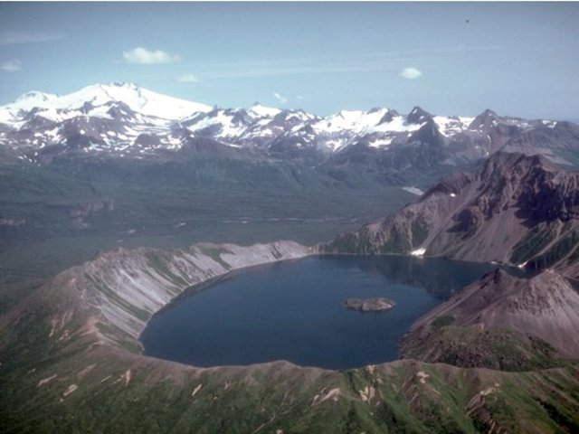 |
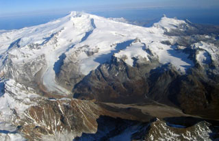
Figure 1. Fourpeaked volcano, the glacier-covered peak at the upper left is one of a group of poorly known volcanoes NE of Katmai National Park. In the foreground of this photo is Kaguyak caldera, which hosts a 2.5-km- wide lake. Pre-eruption photo at uncertain date taken by Chris Nye (Alaska Division of Geological and Geophysical Surveys, Alaska Volcano Observatory. |
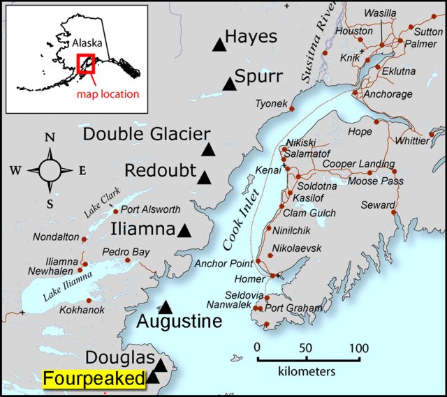 |
Figure 2. A map showing the location of Fourpeaked and Douglas volcanoes, Cook Inlet, and adjacent settlements including the city of Homer on the SW Kenai Peninsula. Created by Seth Snedigar and Janet Schaafer, AVO-ADGGS. |
On the evening of 17 September, AVO received several reports of two discrete plumes rising from the Cape Douglas area. The plumes were photographed at an unstated time on 17 September from the town of Homer (figure 3). At this stage, neither Douglas nor Fourpeaked had devoted seismic instruments.
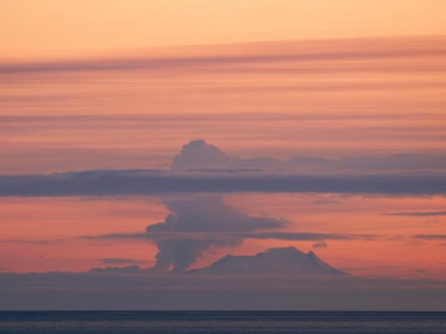 |
Figure 3. A photograph of the eruption of Fourpeaked on 17 September 2006. The photo was taken from Main Street in Homer at an unstated time. Copyrighted photograph by Lanny Simpson, Alaska High Mountain Images (shown on AVO's website). |
Retrospective analysis of data from the NEXRAD Doppler radar in King Salmon showed an unusual cloud starting at 1200 on 17 September. The maximum cloud height determined by radar during the first hour of the event was 6 km altitude. The radar return from the cloud continued until at least 2145 (figure 4).
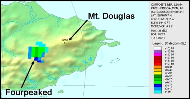 |
Figure 4. Image from the King Salmon NEXRAD weather radar showing the volcanic cloud at Fourpeaked on 17 September 2006 at 1240 (2040 UTC). In color the radar reflectivity ranges from light blue (low) to dark green (moderate), which corresponds to greater numbers and/or sizes of particles. It cannot be determined whether the signal is due to large water droplets, ice particles, coarse-grained ash, or a mixture. Image created by Dave Schneider, AVO/USGS, using data and software from the NOAA National Climatic Data Center. |
A cloud of sulfur dioxide gas was observed by colleagues at the Volcanic Emissions Group at the University of Maryland Baltimore. They used data collected at 1500 by the Ozone Monitoring Instrument (OMI) on NASA's Aura satellite (figure 5).
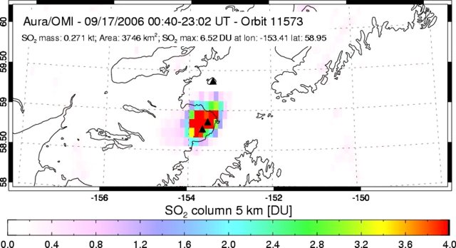 |
Figure 5. Image showing the total amount of sulfur dioxide over Fourpeaked on 17 September 2006 as measured by the Ozone Monitoring Instrument on NASA's Aura satellite. Sulfur dioxide is displayed in Dobson Units (DU, a measure of the number of molecules in a unit area of the atmospheric column). Image created by the Volcanic Emissions Group at the University of Maryland Baltimore County. |
On the basis of the suite of visual, radar, and satellite observations, all the 17 September clouds were inferred volcanic in origin. Although satellite data did not detect ash during this event, AVO received reports of a trace of ashfall at Nonvianuk Lake outlet (110 km WNW) and near Homer (150 km NE). Field observers saw deep scouring of a glacier flowing W from the summit, indicating flooding, probably from the 17 September event.In the caption to a 20 September AVO photo by K.L. Wallace there was noted a "continuous layer of discolored snow and ice above [~1 km elevation,]~3,000 feet asl on the NE flank of Fourpeaked volcano (S of Douglas volcano). Could possibly be ash from the 9/17/06 event."
Both fixed-wing and helicopter overflights in the Cape Douglas area on 20 September confirmed the source of volcanic activity to be Fourpeaked volcano. AVO raised the Level of Concern Color Code from "Not Assigned" to YELLOW on 20 September.
A 23 September observation flight conducted in relatively good weather permitted the first look at the summit since the event of 17 September. Observers saw a linear series of vents running N from the summit for about 1 km. Most of these vents vigorously emitted steam and other volcanic gases. Gas measurements indicated abundant quantities of sulfur dioxide, hydrogen sulfide, and carbon dioxide. Thermal measurements of up to 75°C were recorded at the vents, although steam was likely obscuring hotter areas. Adjacent glacial ice had been disrupted and showed signs of subsidence. Airborne gas measurements taken on 23, 24, and 30 September again documented high emission rates of sulfur dioxide, hydrogen sulfide, and carbon dioxide, and a distinct sulfur smell was evident up to 50 km from the summit. An AVO status report on 3 October noted that cloudy conditions had prevented visual or satellite observations, but limited seismic data being received did not indicate significant volcanic activity.
The AVO reported that volcanic unrest continued at Fourpeaked during 30 September-24 October. A seismometer installed on 25 September indicated ongoing low-level seismicity. Due to the limited number of seismometers, earthquake epicenters were not located. Emission rates of sulfur dioxide were high during 4-10 October and on 27 October. Observations were hindered due to cloud cover, but on 12 October AVO staff reported that two prominent vents were emitting steam and gas. Figure 6 shows several shots illustrating the enlarged opening in the ice on 15 October.
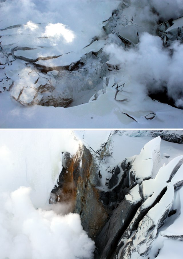 |
Figure 6. Photographs of the steaming vent area at Fourpeaked volcano on 15 October 2006. Courtesy of Kate Bull (AVO-ADGGS). |
On 20 October, field crews installed a web camera located 16 km (10 miles) N of Fourpeaked. Steam plumes originating from vents along the summit were visible via the web camera on 27 and 30 October. Steaming continued through at least 4 November (figure 7).
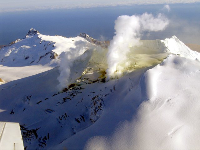 |
Figure 7. A 4 November 2006 photograph documenting steaming on the uppermost section of the northern flank of Fourpeaked volcano. Courtesy of Jennifer Adleman (AVO/USGS). |
Geological Summary. Poorly known Fourpeaked volcano in NE Katmai National Park consists of isolated outcrops surrounded by the Fourpeaked Glacier, which descends eastward almost to the Shelikof Strait. The orientation of andesitic lava flows and extensive hydrothermal alteration of rocks near the present summit suggest that it probably marks the vent area. Eruptive activity during the Holocene had not been confirmed prior to the first historical eruption in September 2006. A N-trending fissure extending 1 km from the summit produced minor ashfall.
Information Contacts: Alaska Volcano Observatory (AVO), a cooperative program of the U.S. Geological Survey, 4200 University Drive, Anchorage, AK 99508-4667, USA; Geophysical Institute, University of Alaska, PO Box 757320, Fairbanks, AK 99775-7320, USA; and Alaska Division of Geological & Geophysical Surveys, 794 University Ave., Suite 200, Fairbanks, AK 99709, USA (URL: http://www.avo.alaska.edu/); S.A. Carn, N.A. Krotkov, A.J. Krueger, and K. Yang, Joint Center for Earth Systems Technology (JCET), University of Maryland Baltimore County (UMBC), 1000 Hilltop Circle, Baltimore, MD 21250, USA.