Report on Soufriere Hills (United Kingdom) — September 2006

Bulletin of the Global Volcanism Network, vol. 31, no. 9 (September 2006)
Managing Editor: Richard Wunderman.
Soufriere Hills (United Kingdom) Extrusive dome dynamics during May-September 2006
Please cite this report as:
Global Volcanism Program, 2006. Report on Soufriere Hills (United Kingdom) (Wunderman, R., ed.). Bulletin of the Global Volcanism Network, 31:9. Smithsonian Institution. https://doi.org/10.5479/si.GVP.BGVN200609-360050
Soufriere Hills
United Kingdom
16.72°N, 62.18°W; summit elev. 915 m
All times are local (unless otherwise noted)
Since the 20 May 2006 dome collapse, the lava dome at Soufrière Hills has continued to grow. Only weeks after the collapse, the alert level was raised to 4 as a result of increased seismic activity. At approximately 1300 on 30 June, the lava dome partially collapsed again, producing pyroclastic flows that traveled E. According to the Washington VAAC, a pilot reported an ash plume that reached ~ 3 km altitude and drifted NW. At 1830 on 30 June, Montserrat Volcano Observatory (MVO) indicated a second dome collapse that also generated ash plumes to an altitude of 3.0-3.5 km (figure 70). According to MVO, on 27 June (prior to the collapse on 30 June) the lava dome had an estimated volume of 27 million cubic meters.
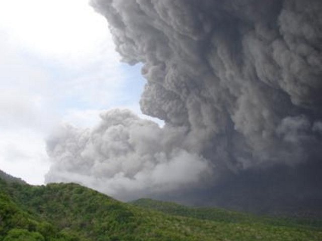 |
Figure 70. A photo taken on 30 June 2006 of Soufrière Hills as viewed from the Montserrat Volcano Observatory showing the first partial dome collapse of the day. The partial collapse began just before 1300 local time and lasted ~ 20 minutes, generating ash clouds to an altitude of ~ 3.5 km that drifted WNW. Pyroclastic flows (left side of picture) were confined to the Tar River valley and ultimately reached the sea. Most of the lava dome remained intact. Photo courtesy of MVO. |
On 7 July, the alert level was lowered from 4 to 3. Increased rockfall activity and dome growth to the NE were observed on 21 July, and the post-collapse dome developed an asymmetric profile owing to a blocky spine on the NE. On 18 July the spine's summit stood at ~ 895 m elevation. As the dome continued to grow during July (figure 71), visual observations revealed that the still intact blocky spine began leaning E.
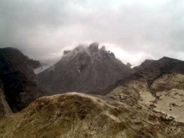 |
Figure 71. A photo of Soufrière Hills taken on 25 July showing spines at the summit of the lava dome as viewed from the NE. Photo courtesy Greg Scott of Caribbean Helicopters. |
During August the dome lost spines from its crest, giving it a more symmetrical profile as it continued to grow E. Heightened activity during the last week of August included an increase in seismicity and pyroclastic flows. On 29 August, pyroclastic flows reached the Tar River valley and generated a steam-and-ash cloud that reached an altitude of ~ 9 km. Heavy rainfall produced mudflows around the base of the volcano.
At 0300 on 31 August, two vigorous ash-and-steam vents opened on the W and N flanks of the dome (figure 72). The venting episode was audible at times from the town of Salem and the surrounding areas. MVO noted the continued dome growth and the opening of these vents when on 31 August they raised the alert level to 4.
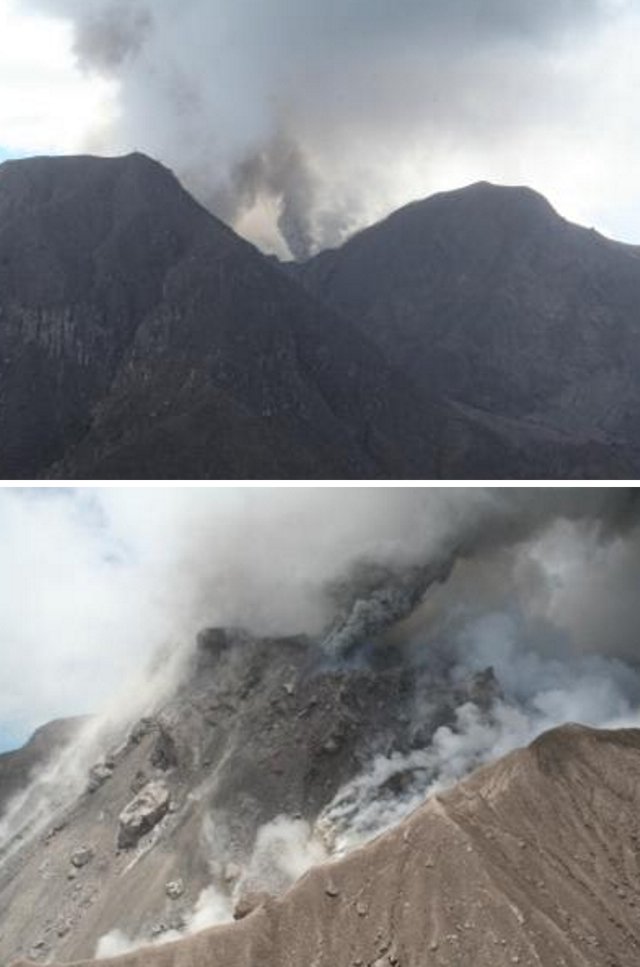 |
Figure 72. Photos showing activity at Soufrière Hills on 31 August 2006. (top) Emissions from the vigorous new vent inside Gages wall (Gages Mountain to the left of the vent and Chances Peak to the right). (bottom) N-looking photo showing the N crater wall, lava dome, and the new vigorous ash vent on the N side of the lava dome. Courtesy of MVO. |
Heightened activity continued in September. The dome continued to develop substantially with a majority of growth on the W side. The vents that opened on 31 August remained active, with the vent above Gage's wall emitting a plume of hot gases and the N vent on the dome producing mainly ash-and-steam (figure 73). The opening of these vents coincided with high lava extrusion rates and consequent dome growth.
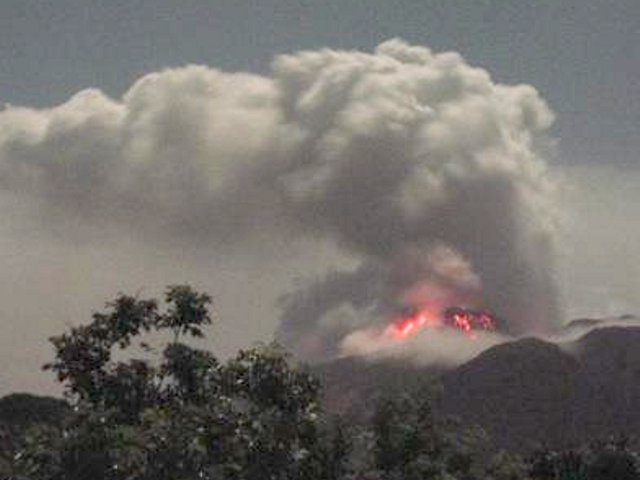 |
Figure 73. A photo showing lava-dome glow viewed from the S at MVO at 2200 on 7 September 2006. Incandescent rocks can be seen tumbling down all flanks of the lava dome on this clear night. A faint glow is visible from the very hot and active gas vent just inside the Gages wall (just right of the dome in the picture). Photo courtesy of MVO. |
At 0100 on 10 September, the vent above Gage's wall became more vigorous throughout the day, broadening the vent and generating a wide vertical ash column. By 1300 the venting there became violent and explosive with black jets of ash rising ~ 100 m. Pyroclastic flows traveled down the Gages valley for ~ 1 km (figure 74). The vent formed a crater in the Gages wall, reducing its height compared to that of Chances Peak by 30-50 m. By 11 September, pyroclastic flows from vent emissions had ceased, but vigorous ash venting continued. At 0830 an overhanging lava lobe that developed on the NE collapsed sending a pyroclastic flow almost to the sea at the end of the Tar River valley.
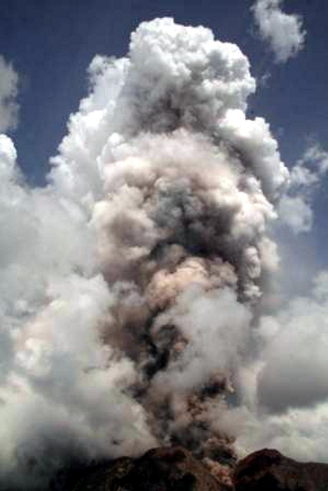 |
Figure 74. A photo showing explosive ash venting from a spot above Gages valley at 1530 on 10 September. Pyroclastic flows can be seen advancing into Gages valley in the foreground. Photo courtesy of MVO. |
Although volcanic tremor ended early on 16 September, an intense episode of volcanic tremor lasting just half an hour started at 1400 on 19 September. It was accompanied by intense rockfall activity giving rise to minor pyroclastic flows down the N and NE flanks of the lava dome. On 21 September the alert level was reduced to 3.
Geological Summary. The complex, dominantly andesitic Soufrière Hills volcano occupies the southern half of the island of Montserrat. The summit area consists primarily of a series of lava domes emplaced along an ESE-trending zone. The volcano is flanked by Pleistocene complexes to the north and south. English's Crater, a 1-km-wide crater breached widely to the east by edifice collapse, was formed about 2000 years ago as a result of the youngest of several collapse events producing submarine debris-avalanche deposits. Block-and-ash flow and surge deposits associated with dome growth predominate in flank deposits, including those from an eruption that likely preceded the 1632 CE settlement of the island, allowing cultivation on recently devegetated land to near the summit. Non-eruptive seismic swarms occurred at 30-year intervals in the 20th century, but no historical eruptions were recorded until 1995. Long-term small-to-moderate ash eruptions beginning in that year were later accompanied by lava-dome growth and pyroclastic flows that forced evacuation of the southern half of the island and ultimately destroyed the capital city of Plymouth, causing major social and economic disruption.
Information Contacts: Montserrat Volcano Observatory (MVO), Fleming, Montserrat, West Indies (URL: http://www.mvo.ms/).