Report on Ubinas (Peru) — October 2006

Bulletin of the Global Volcanism Network, vol. 31, no. 10 (October 2006)
Managing Editor: Richard Wunderman.
Ubinas (Peru) New reporting reveals ashfalls, large ballistic blocks, lahar hazards, and evacuations
Please cite this report as:
Global Volcanism Program, 2006. Report on Ubinas (Peru) (Wunderman, R., ed.). Bulletin of the Global Volcanism Network, 31:10. Smithsonian Institution. https://doi.org/10.5479/si.GVP.BGVN200610-354020
Ubinas
Peru
16.345°S, 70.8972°W; summit elev. 5608 m
All times are local (unless otherwise noted)
Ubinas began erupting ash on 25 March 2006 (BGVN 31:03 and 31:05); ash eruptions and steam emissions continued through at least 31 October 2006. Eruptive benchmarks during that period included a lava dome in the crater on 19 April. Ashfall in late April forced the evacuation of Querapi residents, who resided ~ 4.5 km SE of the crater's active vent, to Anascapa (S of the summit). Ash columns rose to almost 8 km altitude during May.
This report discusses ongoing eruptions through 31 October 2006 as drawn from Buenos Aires Volcanic Ash Advisory Center (VAAC) reports and especially from an enlightening 26-page report published in Péru during September 2006 by the Institutio Geológico Minero y Metalúrgico?INGEMMET (Salazar and others, 2006). It includes a detailed digital elevation map with hazard zones.
Background. Ubinas lies 90 km N of the city of Moquegua and 65 km E of the city of Arequipa (figure 4). The bulk of adjacent settlements reside to the SE, and generally at more distance, towards the E. Figure 5 shows a shaded region where airfall deposits took place during the span 1550-1969. The zone of deposits includes some modern settlements.
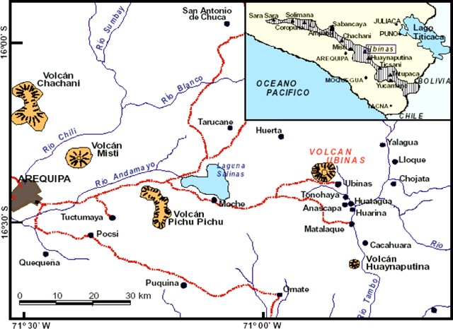 |
Figure 4. Map indicating the geographic setting of the Perúvian volcanic front (inset) and the area around Ubinas. From Salazar and others (2006). |
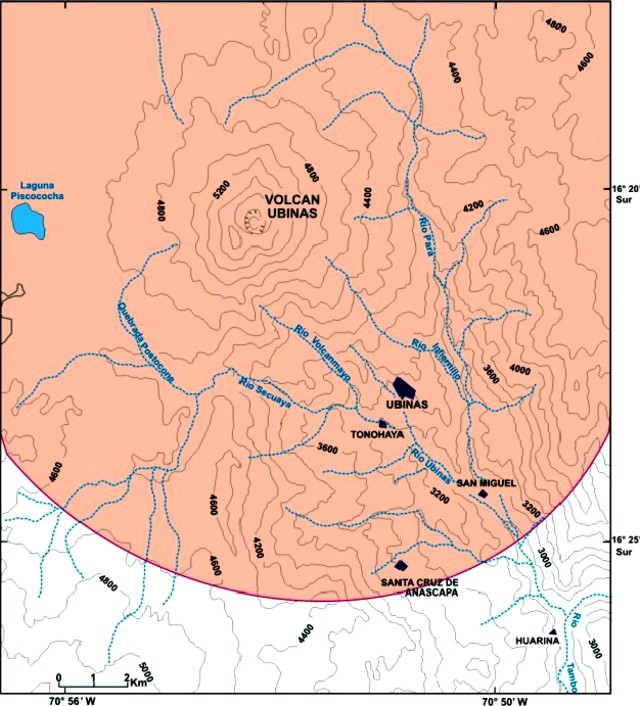 |
Figure 5. The boundary of identified Ubinas ashfall from the years 1550 to 1969 appears as a curve across the S portion of this map, 10-12 km from the summit crater. Note the SE-sector settlements (and their respective distances from the summit crater) for the district capital Ubinas (6.5 km), Tonohaya (7 km), San Miguel (10 km), and Santa Cruz de Anascapa (~ 11 km), and Huarina (15 km). Map taken from Rivera (1998). |
The geologic map on figure 6 shows the area of the settlements SE of the summit includes large Holocene deposits, including those from debris avalanche(s) at ~ 3.7 ka, and units containing pyroclastic flows. The map also indicates deposits of volcaniclasics, glacial moraines, airfall-ash layers, and lava flows. Extensive Miocene deposits envelope both the NE flanks (Pampa de Para) and SW flanks.
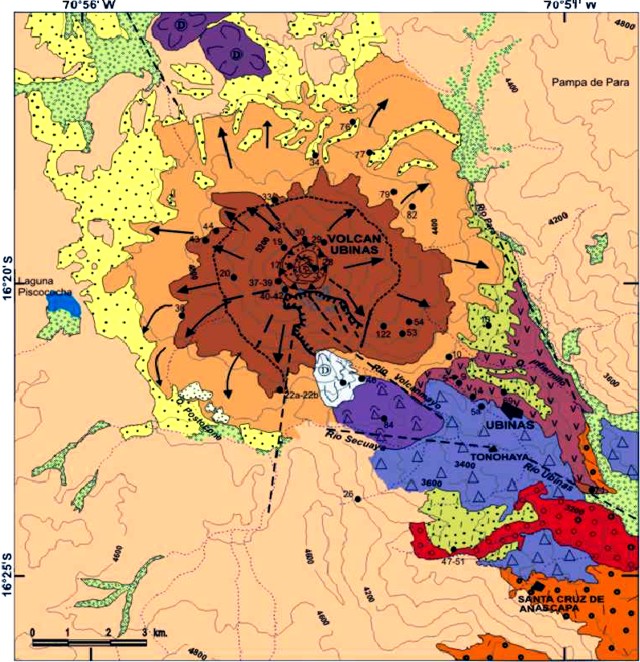 |
Figure 6. Geologic map of Ubinas shown here without the key, which is available in the original report. From Salazar and others (2006). |
The map of hazard zones (figure 7) indicates a nested, tear-drop shaped set of zones, with comparatively lower inferred hazard to the NE and NW. The SE-trending, elongate area of hazards follows the key drainage in that direction. Elevated hazard zones also follow many of the roads passing through the region.
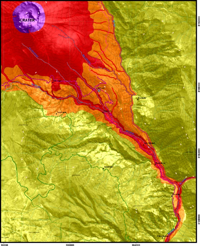 |
Figure 7. The SE corner of the Ubinas hazard map, showing the central crater, and the hazard zones that follow the main drainage (Rio Ubinas) leading SE through the most populated region close to the volcano. Map key is omitted. Margins of the map note that its construction was a partnership of numerous groups, including French collaborators at Blaise Pascal University and IRD. Taken from Salazar and others (2006). |
Eruptions during 2006. Salazar and others (2006) reported that the current eruptive crisis could be divided into three stages. During July 2005-27 March 2006, the eruption was primarily gas discharge rising 100-300 m above the crater. During 27 March-8 April the eruptions consisted of ash emissions and gas produced by phreatic activity (figure 8). After a moderate explosion on 19 April, Ubinas produced ash and gas, and explosions ejected volcanic bombs. Several views into the crater appear on figure 9.
 |
Figure 8. Ubinas gas emissions as seen from unstated direction on 4 April 2006. From Salazar and others (2006). |
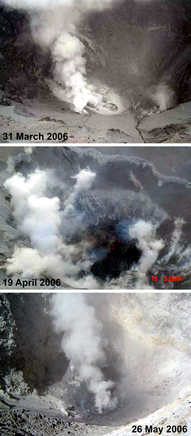 |
Figure 9. Views looking down into the Ubinas crater on 31 March, 19 April, and 26 May 2006. The former was taken in comparatively mild conditions. The 19 April photo was taken when a 60-m-diameter lava body was first seen on the crater floor (the color version of this photo shows faint red incandescence penetrating the steamy scene). The 26 May captured a relatively clear view of the steaming dome on the crater floor. March and April photos from and Salazar and others (2006); May photo from the INGEMMET website. |
On 7 May 2006 a moderate explosion sent ash to ~ 3 km above the summit. Although the situation calmed in the following days, an impressive bomb fell 200 m from the crater on 24 May 2006 (figure 10). Larger outbursts occurred on 29 May and 2 June, prompting the civil defense decision to evacuate residents in the S-flank Ubinas valley, including the settlements of Ubinas, Tonohaya, San Miguel, Huatahua, and Escacha. Residents evacuated were lodged in refugee camps (figure 11).
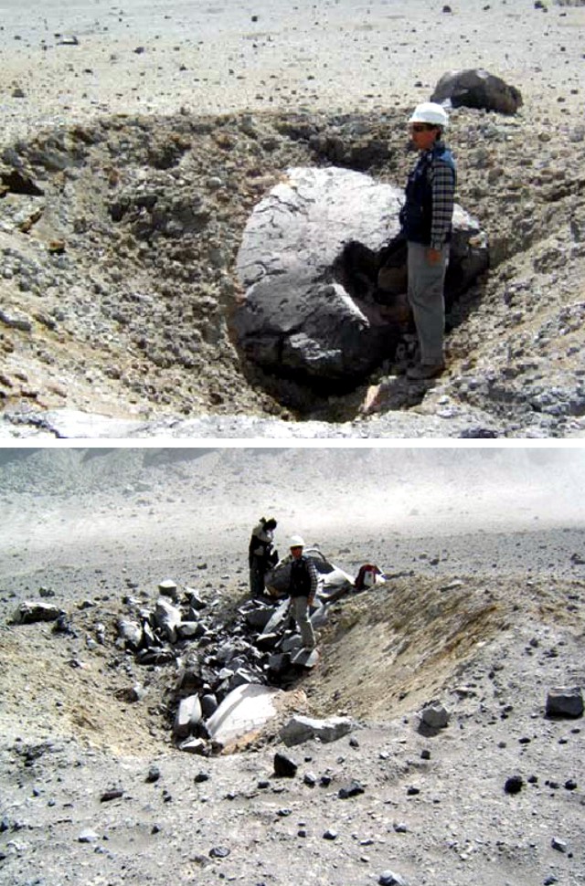 |
Figure 10. Ubinas eruptions in May 2006 ejected volcanic bombs, seen here in their impact craters. A 2-m-diameter bomb (top), struck ~ 200 m from the crater. A crater containing a large, partly buried, smooth-faced bomb is seen in the bottom photo. Numerous bucket-sized angular blocks appear on the far side of the impact crater. Two geologists stand adjacent a ~ 2-m-long block that ended up on the impact crater's rim. The bomb fragments were of andesitic composition. Top photo from Salazar and others (2006); bottom photo from INGEMMET website. |
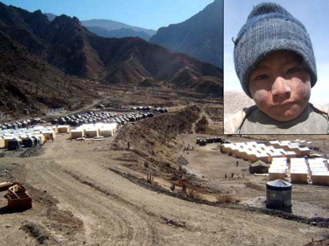 |
Figure 11. Settlement camp housing families taking refuge from Ubinas ash. This camp, named Chacchagen, housed people from the S-flank settlements of Ubinas, Tonohaya, San Miguel, Huatahua, and Escacha. Inset shows the ash-dusted face of a local child. Courtesy of Salazar and others (2006). |
On 18 June instruments recorded two explosions. Ash clouds discharged; the second one also ejected incandescent blocks ~ 1 km SE of the crater. The early stages of a rising plume seen at 0822 on 18 July appears on figure 12. Similar magnitude ash emissions were noted on 23, 24, and 30 June 2006, and incandescent rocks fell up to 1.2 km from the summit crater. During 10, 17-19, 22, 27 July, and 7 August 2006 there were various explosions (figure 12). Resulting ash clouds extended more than 70 km SE or SW.
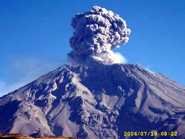 |
Figure 12. A moderate Ubinas explosion on 18 July 2006 generated this rising ash plume. Courtesy of Salazar and others (2006). |
In August 2006, ash plumes reached 4.6-7.6 km altitude and were occasionally visible on satellite imagery. The direction of drift of the ash varied widely. On 12 August, ash dispersed more than 100 km to the SE and S. On 14 August an astronaut on the International Space Station took a picture of the ash plume from Ubinas (figure 13).
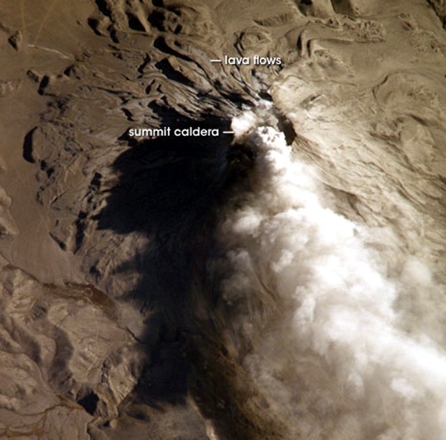 |
Figure 13. This image taken from the International Space Station (ISS) captures Ubinas discharging a light-colored ash cloud roughly to the S (N is up on this photo). The cloud had been observed earlier on satellite imagery at 0600 local (1100 UTC) on 14 August 2006. One-hour and 45-minutes later (at 1245 UTC), an ISS astronaut took this picture at non-vertical (oblique) angle to the Earth. Pumice and ash blanket the volcanic cone and surrounding area, giving this image an overall gray appearance. Shadows on the N flank throw several older lava flows into sharp relief. (Photograph ISS013-E-66488 acquired with a Kodak 760C digital camera using an 800 mm lens). Photo provided by the ISS Crew. |
The most significant effect on people and the environment has come from ashfall (figure 14). GOES satellite images indicate visible airborne ash for distances greater than 60 km from the vent. Figure 14 indicates net ash accumulation through about August 2006, extrapolating sampling points with concentric circles. The report specifically noted ash thicknesses of 1.5 cm at ~ 4.5 km SE in Querapi, 0.1-0.8 cm in Sacoaya, 0.5-0.8 cm in Ubinas, 0.3-0.4 cm in Anascapa, 0.15 mm in Huatahua, and less than 0.1 cm in Chacchagén. The accumulation has apparently been due to ongoing ashfalls On 13 April, several millimeters of ash dusted all surfaces in Querapi, ~ 4.5 km from the center of the summit crater.
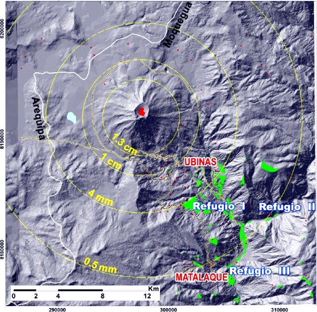 |
Figure 14. Net ash accumulation around Ubinas from start of eruption in March through about August 2006. Ash has covered agricultural fields in the valley and pastures in the highlands, seriously affecting the two main economic activities in the area, agriculture and cattle ranching; and has caused respiratory and skin problems. Courtesy of Salazar and others (2006). |
Aviation reports of ash plumes. As summarized in table 2, ash clouds were reported by the Buenos Aires Volcanic Ash Advisory Center (VAAC) on 2 May and then during 2 August through October on a nearly daily basis. The observation sources were usually pilot's reports (AIREPs) and/or satellite images (GOES 12). After 8 August, ash emissions were essentially continuous to 31 October. During the later interval, the aviation color code was generally Red. Plumes rose to 10 km and higher during 23-26 October.
Table 2.Compilation of aviation reports (specifically, 195 Volcanic Ash Advisories, VAAs) on Ubinas and its plumes during May through 31 October. The second column shows some contractions used in the table (eg., "VA CLD FL 160" means "Volcanic ash cloud at Flight Level 160"). Flight Level is an aviation term for altitude in feet divided by 100 (eg., FL 200 = 20,000 feet = ~ 7 km altitude). Courtesy of the Buenos Aires VAAC.
| Observation date (2006) | Eruption details: VA (Volcanic Ash), CLD (Cloud), OBS (Observed), FL (Flight Level) |
| 02 May | VA CLD FL180/200 MOV SE |
| 02 Aug | VA CLD DENSE ASH CLD FL160/230 MOV NE. ASH POORLY DEFINED VISIBLE GOES-12 SATELLITE IMAGE |
| 03 Aug-04 Aug | VA CLD FL220/240 MOV SW |
| 05 Aug | VA CLD OBS FL370 MOV NE |
| 06 Aug-07 Aug | VA CLD OBS. ACTIVITY REPORTED CONTINUOUS AND INCREASING EMISSION FL160/260 SNTR OVER PEAK SPREAD FROM THE SUMMIT IN ALL DIRECTIONS UP TO A DISTANCE OF 20 KM |
| 07 Aug-08 Aug | VA CLD OBS FL200 MOV E/NE |
| 10 Aug-14 Aug | VA CLD OBS FL180/245 MOV SE. ASH OBS IN SATELLITE IMAGE |
| 17 Aug-18 Aug | VA CLD FL 160-200 MOV SE/ESE APROX. 60NM |
| 19 Aug | VA CLD FL180/250 MOV SW |
| 20 Aug-21 Aug | VA CLD FL180/230 MOV ESE/SE APROX. 20NM |
| 22 Aug | VA CLD OBS FL180/300 STNR ~ MOV SE |
| 25 Aug-26 Aug | VA CLD OBS FL230/235 MOV S. ASH NOT IDENTIFIABLE ON SATELLITE IMAGERY |
| 28 Aug-30 Aug | VA CLD OBS FL160/250 MOV SE. SATELLITE IMAGERY REVEALED A LIGHT TRACE OF ASH EXTENDING TO SE OF THE SUMMIT |
| 31 Aug | VA CLD OBS FL 160/250 APROX MOV NE~E |
| 01 Sep-23 Sep | VA CLD OBS FL 160/250 MOV NE~E |
| 24 Sep | VA CLD FL300 MOV SSE |
| 27 Sep | VA CLD OBS FL180/230 and up to FL280 |
| 01 Oct-11 Oct | VA CLD OBS FL160/180 MOV E~ S |
| 12 Oct-14 Oct | Emissions intermittent. VA CLD OBS FL160/220 MOV SE~NE~N |
| 15 Oct-21 Oct | VA CLD FL160~ 240 MOV S~ SE |
| 23 Oct-26 Oct | VA CLD FL180/350 (Unusually high altitude) MOV N~E~W |
| 26 Oct-29 Oct | VA CLD FL180/240 MOV N~NW swing to S |
| 30 Oct-31 Oct | VA CLD FL 280/300 MOV SW |
References. Rivera, M., 1998, El volcán Ubinas (sur del Perú): geología, historia eruptiva y evaluación de las amenazas volcánicas actuales: Tesis Geólogo, UNMSM, 132 p.
Rivera, M., Thouret, J.C., Gourgaud, A., 1998, Ubinas, el volcán mas activo del sur del Perú desde 1550: Geología y evaluación de las amenazas volcánicas. Boletin de la Sociedad Geológica del Perú, v. 88, p. 53-71.
Salazar, J.M., Porras, M.R., Lourdes, C.D., and Pauccara, V.C., 2006, Evaluación de seguridad físca de áreas aledañas al volcán Ubinas: INGEMMET (Instituto Geológico Minero y Metalúrgico Dirección de Geología Ambiental, September 2006), 26 p.
Thouret, J.C., Rivera, M., Worner, G., Gerbe, M.C., Finizola, A., Fornari, M., and Gonzales, K., 2005, Ubinas: the evolution of the historically most active volcano in southern Perú: Bull. Volc., v. 67, p. 557-589.
Geological Summary. The truncated appearance of Ubinas, Perú's most active volcano, is a result of a 1.4-km-wide crater at the summit. It is the northernmost of three young volcanoes located along a regional structural lineament about 50 km behind the main volcanic front. The growth and destruction of Ubinas I was followed by construction of Ubinas II beginning in the mid-Pleistocene. The upper slopes of the andesitic-to-rhyolitic Ubinas II stratovolcano are composed primarily of andesitic and trachyandesitic lava flows and steepen to nearly 45°. The steep-walled, 150-m-deep summit crater contains an ash cone with a 500-m-wide funnel-shaped vent that is 200 m deep. Debris-avalanche deposits from the collapse of the SE flank about 3,700 years ago extend 10 km from the volcano. Widespread Plinian pumice-fall deposits include one from about 1,000 years ago. Holocene lava flows are visible on the flanks, but activity documented since the 16th century has consisted of intermittent minor-to-moderate explosive eruptions.
Information Contacts: Jersy Mariño Salazar, Marco Rivera Porras, Lourdes Cacya Dueñas, Vicentina Cruz Pauccara, Instituto Geológico Minero y Metalúrgico (INGEMMET), Av. Canadá No 1470, Lima, Perú (URL: http://www.ingemmet.gob.pe/); Buenos Aires Volcanic Ash Advisory Center, Servicio Meteorológico Nacional, Argentina (URL: http://www.smn.gov.ar/vaac/buenosaires/productos.php); ISS Crew, Earth Observations Experiment and the Image Science & Analysis Group, NASA Johnson Space Center, 2101 NASA Parkway Houston, TX 77058, USA (URL: http://www.nasa.gov/centers/johnson/home/); National Aeronautics and Space Administration (NASA) Earth Observatory (URL: http://earthobservatory.nasa.gov/NaturalHazards/).