Report on Karymsky (Russia) — November 2006
Bulletin of the Global Volcanism Network, vol. 31, no. 11 (November 2006)
Managing Editor: Richard Wunderman.
Karymsky (Russia) Moderate ash explosions and continued dome growth
Please cite this report as:
Global Volcanism Program, 2006. Report on Karymsky (Russia) (Wunderman, R., ed.). Bulletin of the Global Volcanism Network, 31:11. Smithsonian Institution. https://doi.org/10.5479/si.GVP.BGVN200611-300130
Karymsky
Russia
54.049°N, 159.443°E; summit elev. 1513 m
All times are local (unless otherwise noted)
During late 2006 and into January 2007, ash explosions occurred from the summit crater at Karymsky, continuation of activity observed since the beginning of January 2006 (BGVN 31:04 and 31:07). This report covers activity during August 2006 to early January 2007.
The Kamchatka Volcanic Eruptions Response Team (KVERT) maintained the level of Concern Color Code at orange during the period of reporting, except for the temporary change to yellow during 8-15 September. Throughout this period the dome was a consistent source of thermal anomalies.
Ash plumes reached to ~3.0-3.7 km altitude throughout August 2006. Seismicity rose, with a maximum of 500 local shallow earthquakes per day the week of 18 August, and then lowered to 30-70 earthquakes per day the last week of August. Spasmodic tremor registered on 1-12 and 17 August. On 6 August an ash plume extending ~ 10-73 km E and SE was depicted on satellite data. Volcanic plume information sometimes stems from the Airport Meteorological Center (AMC) in Yelizovo (a town 40 km NE of the S-coast town of Petropavlovsk-Kamchatsky; the latter is the Peninsula's capital, largest city, and features both a major airport and a marine port). The AMC reported that on 16 August, pilots saw a Karymsky ash plume at ~6.5 km altitude that extended NE.
During September 2006, local shallow earthquakes occurred ~ 30-250 times per day. A satellite image for 12 September showed an ash plume extending ~140 km SE. On 10 September volcanologists observed from visual data an ash explosion of [~2.3 km] altitude. Other possible ash explosions were thought to occur toward the end of September 2006, reaching heights of ~2.5-4.5 km altitude.
Local seismicity peaked the last week of October with a maximum of 550 weak shallow earthquakes per day, but levels declined through November 2006. Possible ash explosions rising ~2.5-5.0 km altitude prevailed the month of October and during 10-11 and 18-19 November. On 25 October staff of the Institute of Volcanology and Seismology (IVS) observed a series of ash bursts up to ~2.0 km above the summit with ash plumes that extended ~100 km E. On days of sufficient visibility during October and November 2006, ash plumes often extended ~29-200 km NE, ~20-220 km SE, and ~ 55-137 km E (figure 13). On 28 October observers noted an ash cloud extending to 70 km NE of Karymsky.
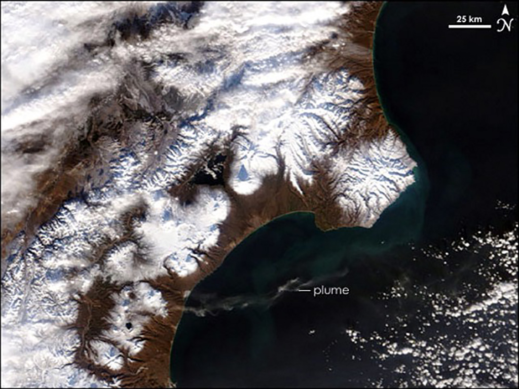 |
Figure 13. Satellite image showing Karymsky and environs, with its faint E-directed plume easily visible over the ocean. Karymsky's vent lies ~25 km W of the point where the plume intersects the coast. The image was taken by the Moderate Resolution Imaging Spectroradiometer (MODIS) satellite on 29 November 2006. Courtesy of NASA Earth Observatory. |
There were no seismic data the last week of November to the third week December 2006, but satellite data enabled surveillance. Figure 14 shows a 19 December image from the Advanced Spaceborne Thermal Emission and Reflection Radiometer (ASTER) instrument on the Terra satellite.
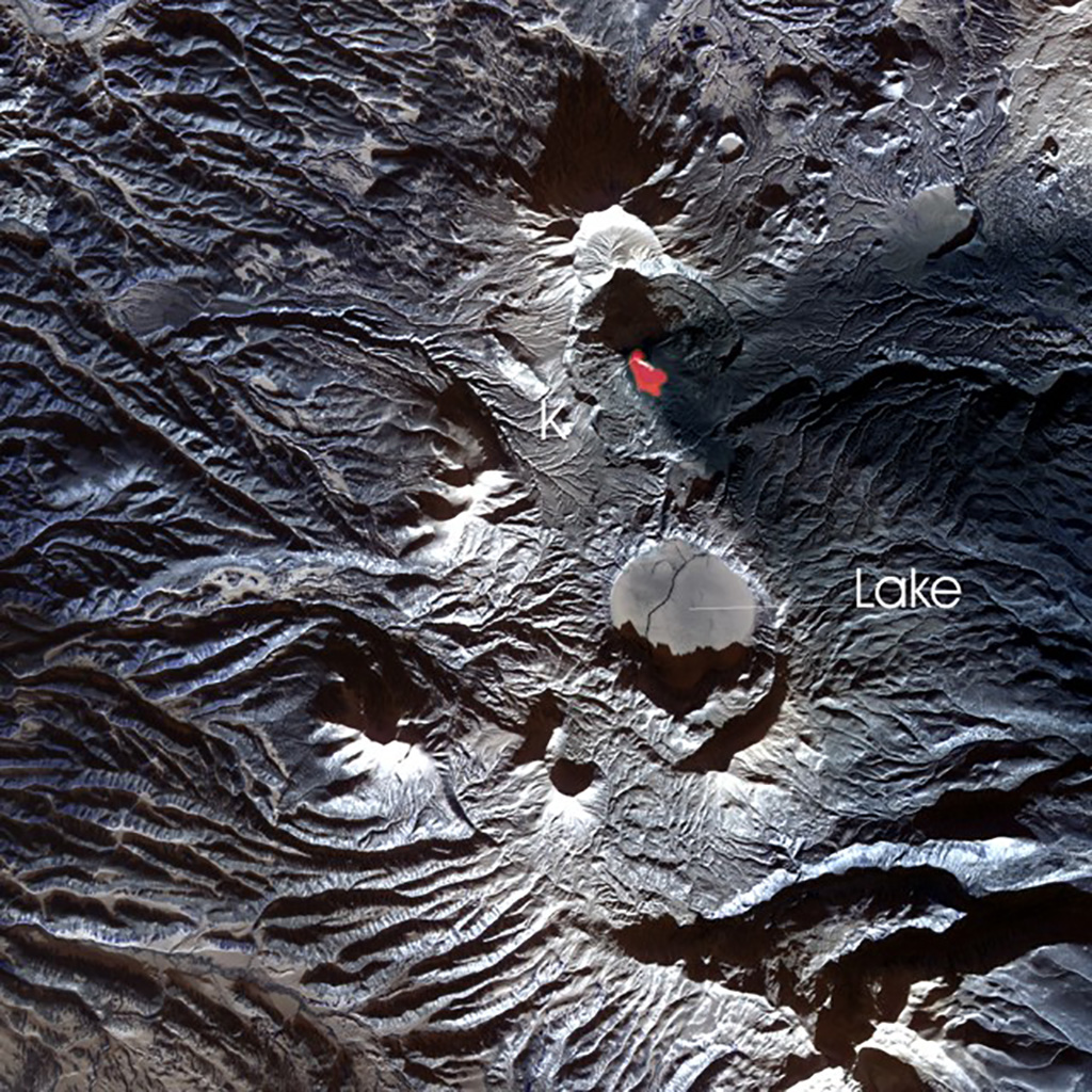 |
Figure 14. ASTER image of Karymsky ("K" marks the summit) and surroundings taken on 19 December 2006. N is towards the top. The area indicated as hot near the summit (which is false-colored red on color images) indicates a volcanically induced hotspot, and the tiny white streak over the hotspot may be a steam plume. A broad, dark cast spreads E across the right side of the image (the fringes of which are indicated by "F"). This zone narrows to a point near Karymsky's summit; it results from fresh ash deposits draping the landscape. Although myriad ridges and valleys corrugate much of the landscape, a zone without those features resides several kilometers S of the summit. That is Karymsky lake ("Lake"), which lies in a caldera. From Karymsky's summit to the nearest margin of Karymsky Lake, the distance is ~5 km (see maps and scaled images in previous reports, Eg. BGVN 21:05, 31:07). This NASA image created and interpreted by Jesse Allen, NASA Earth Observatory, using data provided courtesy of the NASA/GSFC/MITI/ERSDAC/JAROS, and US/Japan ASTER Science Team. |
During the week of 29 December and the first week in January 2007 there were multiple weak local shallow earthquakes. They occurred at a rate of 100-130 per day during the week of 29 December. On 29 December and 1-3 January tremor was also registered.
According to visual information from pilots of international air flights (reported by AMC, Yelizovo), on 2 December an ash plume rose up ~ 6.9 km altitude and extended E. At 0200 on 22 December an ash plume rose up to ~ 7.0 km altitude and extended E. A number of ash plumes extending 9 to 240 km E were observed during December. At the end of December 2006 and into early January 2007, a possible lava flow was observed on a flank of the volcano.
Geological Summary. Karymsky, the most active volcano of Kamchatka's eastern volcanic zone, is a symmetrical stratovolcano constructed within a 5-km-wide caldera that formed during the early Holocene. The caldera cuts the south side of the Pleistocene Dvor volcano and is located outside the north margin of the large mid-Pleistocene Polovinka caldera, which contains the smaller Akademia Nauk and Odnoboky calderas. Most seismicity preceding Karymsky eruptions originated beneath Akademia Nauk caldera, located immediately south. The caldera enclosing Karymsky formed about 7600-7700 radiocarbon years ago; construction of the stratovolcano began about 2000 years later. The latest eruptive period began about 500 years ago, following a 2300-year quiescence. Much of the cone is mantled by lava flows less than 200 years old. Historical eruptions have been vulcanian or vulcanian-strombolian with moderate explosive activity and occasional lava flows from the summit crater.
Information Contacts: Olga A. Girina, Kamchatka Volcanic Eruptions Response Team (KVERT), a cooperative program of the Institute of Volcanic Geology and Geochemistry, Far East Division, Russian Academy of Sciences, Piip Ave. 9, Petropavlovsk-Kamchatsky, 683006, Russia, GS RAS (Russia), and the Alaska Volcano Observatory (AVO), a cooperative program of the U.S. Geological Survey, 4200 University Drive, Anchorage, AK 99508-4667, USA (URL: http://www.avo.alaska.edu/), the Geophysical Institute, University of Alaska, PO Box 757320, Fairbanks, AK 99775-7320, USA, and the Alaska Division of Geological and Geophysical Surveys, 794 University Ave., Suite 200, Fairbanks, AK 99709, USA; Jesse Allen, National Aeronautics and Space Administration Earth Observatory (URL: http://earthobservatory.nasa.gov/NaturalHazards).