Report on Home Reef (Tonga) — December 2006
Bulletin of the Global Volcanism Network, vol. 31, no. 12 (December 2006)
Managing Editor: Richard Wunderman.
Home Reef (Tonga) Island photographs; pumice description; pumice tracking
Please cite this report as:
Global Volcanism Program, 2006. Report on Home Reef (Tonga) (Wunderman, R., ed.). Bulletin of the Global Volcanism Network, 31:12. Smithsonian Institution. https://doi.org/10.5479/si.GVP.BGVN200612-243080
Home Reef
Tonga
18.992°S, 174.775°W; summit elev. -10 m
All times are local (unless otherwise noted)
The island built by the eruption from Home Reef in early August (BGVN 31:09 and 31:10, table 1) was directly observed on 14 November and 7 December. No additional information about the eruption site has been received after 7 December.
Table 1. Summary of activity at Home Reef, August-December 2006. Only near-source observations are included, not dispersed pumice sightings. Revised area calculations were made using a Google Earth tool. Data supplemented, especially with additional satellite observations, from a table originally prepared by Paul Taylor.
| Date | Activity / Phenomena |
| 05 Aug 2006 | MODIS satellite image shows no activity. |
| 08 Aug 2006 | At 1020 local time (2120 UTC on 7 Aug) MODIS image shows eruption plume surrounded by roughly 8-km-diameter circular pumice raft (55 km2). The diffuse eruption plume was seen in imagery extending 80 km SSW and 70 km SSE. MODIS image at 1445 (0145 UTC) showed larger pumice raft still attached to vent, and diffuse plume visible to 300 km S. SO2 first detected by OMI on Aura satellite. Late in the afternoon a continuous rumbling like thunder was heard from Vava'u; red glow was seen on the horizon that evening. |
| 09 Aug 2006 | Continuous rumbling like thunder to the S of Vava'u, large mushroom-shaped eruption plume was being ejected above the vent in the morning. MODIS imagery at 1103 local time (2203 UTC on 8 Aug) showed that the pumice raft was still attached to vent, but had drifted to the W and was approximately 150 km2. White eruption plume quickly lost in cloud cover. SO2 mass (determined by OMI) detected E of Tonga was ~ 25 kilotons. |
| 10 Aug 2006 | Continuous rumbling like thunder to the S of Vava'u. MODIS imagery at 1432 (0132 UTC) shows that a large pumice raft has moved N of Late Island (20 km NE). Some pumice remains around vent site, but is hidden by eruptive plume. Submarine plume of discolored water extends to Late Island. Diffuse plumes extend at least 100 km SE and 330 km NW. |
| 11 Aug 2006 | Continuous rumbling like thunder to the S of Vava'u, large eruption plume above the vent. MODIS imagery at 1052 (2152 UTC on 10 Aug) showed a thin white eruption plume directed 25 km SW before being lost in cloud cover. No significant pumice raft seen near the vent, but there was an extensive area (150 km2) of discolored water surrounding the site. |
| 12 Aug 2006 | Eruption column moving NW reported by crew of the yacht Maiken. Surtseyan explosive jets being emitted, producing projectiles that fell to the sea around the vent area. Multiple peaks had formed around a central crater that was open to the sea on one side. The island was about 1.5 km in diameter. OMI detection of SO2 shows 3.3 kilotons in the area. |
| 14 Aug 2006 | MODIS image at 1405 (0105 UTC) shows small E-directed white plume, probable island, and large area of strongly discolored water (30 km2) E of the island. Sinuous submarine plume of discolored water extends 60 km NW. |
| 16 Aug 2006 | Island was completely covered by clouds in a MODIS image at 1110 (2210 UTC on 15 Aug), but a plume of discolored water stretched more than 50 km N to some pumice rafts. |
| 17 Aug 2006 | MODIS imagery at 1435 (0135 UTC) revealed meteorological clouds streaming from Late Island and Home Reef. Discolored water throughout the area N towards Late, and extending 80 km N to large pumice rafts. No significant pumice rafts seen near the island. |
| 19 Aug 2006 | No eruption plume seen from island in MODIS imagery at 1425 (0125 UTC). Weakly discolored water patches extending NNW. |
| 22 Aug 2006 | Small whitish cloud attached to island seen in MODIS image at 1030 (2130 UTC on 21 Aug) may be meteorological (similar clouds attached to Late). Strongly discolored water in narrow submarine plume very coherent to 8 km NE before diffusing and moving NW. |
| 23 Aug 2006 | MODIS imagery at 1115 (2215 UTC on 22 Aug) very cloud-covered, but large zone of discolored water located N of the island. |
| 27 Aug 2006 | Island present on MODIS image at 1050 (2150 UTC on 26 Aug) with a coherent submarine plume being dispersed to the N. |
| mid-Sep 2006 | Island reported present at the site of Home Reef by Tongan fishing vessel. |
| 20 Sep 2006 | "Strong sulfur odor" noted by a yacht passing W of the volcano. |
| 04 Oct 2006 | Several submarine plumes observed on ASTER images. The island present was oval in shape, with the long axis orientated NE-SW. The island measured about 800 x 400 m and covered an area of 0.23-0.26 km2. Several small lakes were present within the island. |
| 12 Nov 2006 | No activity observed on ASTER images. Island was still present but with no crater lakes. The island was triangular in shape and covered an area of 0.146 km2. |
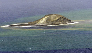
| 14 Nov 2006 | Island observed by Defence Force patrol boat was ~40 m high, square in shape, 300 m on a side. The island looked quite consolidated. Plume of smoke/steam, but no eruptive activity. |
| 07 Dec 2006 | Overflight by a RNZAF Orion revealed a roughly circular island, 450 m in diameter, at 18°59.4'S 174°45.4'W. The crew estimated the height as "up to 240 ft" (75 m). Minor fumarolic activity was occurring in the crater and there was a noticeable smell of sulfur. Sediment/hydrothermal plumes were present in the surrounding waters. |
Paul Taylor reported that the Home Reef island was observed on 14 November by a Tongan Defence Force patrol boat. The island was reported to be ~ 40 m high, roughly 300 x 300 m at that time, and looked quite consolidated with pumice on the outside, while the center looked "more substantial." Although not in eruption, a considerable plume of smoke/steam was being emitted.
The island was photographed on 7 December 2006 (figure 18) by the Royal New Zealand Air Force (RNZAF) at the request of volcanologists from the Institute of Geological & Nuclear Sciences (IGNS). Satellite imagery on 4 October showed an island about 0.24 km2, which decreased by about one-third to 0.15 km2 by 12 November. The RNZAF Orion crew reported that the roughly circular island was 450 m in diameter (0.16 km2), with a maximum height of 75 m (figure 19). The position was reported as 18°59.4'S, 174°45.4'W (18.99°S, 174.757°W). Minor fumarolic activity was occurring in the crater and there was a noticeable smell of sulfur. Plumes of discolored water were present in the surrounding area. The higher-angle views of the island showed an area that had eroded to just below the ocean surface, possibly reflecting the previous extent of the island.
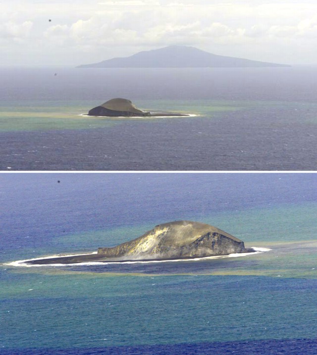 |
Figure 18. Low-angle aerial photographs of Home Reef, 7 December 2006. The top view is looking NNE towards Late Island in the background. The bottom view is looking S. Courtesy of the RNZAF and IGNS. |
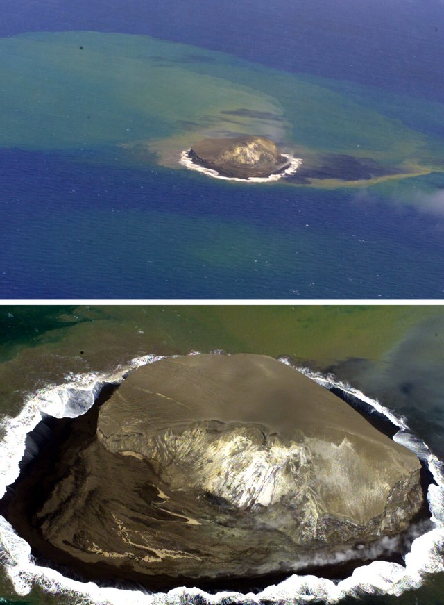 |
Figure 19. High-angle aerial photographs of Home Reef, 7 December 2006. The top view is looking approximately W, showing that the northern end of the island has eroded to just below sea level. Submarine plumes of sediment are also obvious. The bottom view is looking approximately SE, showing a close-up of the eroding remnant of the island. Courtesy of the RNZAF and IGNS. |
Floating pumice observations. Pumice from the Home Reef eruption was identified in Terra and Aqua MODIS satellite images as well as being reported by sailors and Fijians (BGVN 31:09 and 31:10). A compilation of all of these sources (figure 20) seemed to indicate that two major tracks were taken by most of the pumice. Initially, all of the pumice went N, then WNW across the ocean towards Fiji. Approximately midway to Fiji, some of the pumice turned on a more westerly course then moved south before impacting Vatoa and passing the southern Lau Islands enroute to Kadavu and Vanua Levu. Another batch of pumice continued on a WNW course, penetrating the northern Lau Islands to Taveuni, the Koro Sea, and Viti Levu. Both groups of pumice eventually passed W of Fiji, with some getting to Vanuatu in November. Most of the pumice appears to have been generated during 8-10 August, but there may have been smaller pumice-creating eruptions that were not documented.
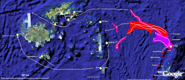 |
Figure 20. Map showing approximate paths taken by pumice generated by the Home Reef eruption in August 2006. Paths between Tonga and Fiji during 8-26 August (shaded areas) are based on MODIS satellite imagery (see text for further explanation). Paths through Fiji are more speculative, being based on point observations by sailors and reports of pumice washing into bays and on beaches. Base map from Google Earth. Prepared by GVP. |
Satellite imagery revealed not only the paths taken by pumice rafts, but also their changing morphology. Although cloud-cover was a problem, the MODIS images did show enough pumice zones to allow their areas to be sketched (figure 21). Note that all dates and times in this section are UTC. During the early stages of the eruption pumice built up and remained in the immediate vicinity of the vent (2120 on 7 August through 2203 on 8 August UTC) (figure 21A). Though clouds prevented a view of the entire raft, at it's greatest extent pumice covered about 140 km2 while still attached to the vent.
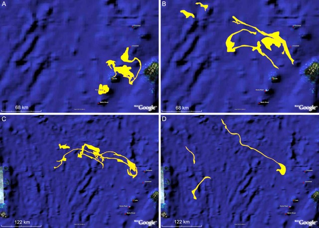 |
Figure 21. Sketches of pumice areas on various dates in August 2006 from the eruption at Home Reef. Areas depicted may not be filled with pumice, but have observable pumice scattered within them. Sketch maps show pumice areas (in UTC) on 7-8 August (A, SW section), 10-12 August (A, NE section), 14-17 August (B), 19-22 August (C), and 26 August (D). See text for additional information. The areas were determined by overlaying geographically registered MODIS satellite imagery into Google Earth and using a polygon creation tool to manually determine the pumice extents. Base map from Google Earth. Prepared by GVP. |
By 0132 on 10 August the main mass of pumice had moved to the N side of Late island (figure 21A). The raft generally remained as a single large coherent feature in that area for at least 20 hours. Over those 20 hours the raft spread from covering about 300 km2 to almost 400 km2 in a contiguous irregular area, more than double the area of Washington D.C. When it began moving NE towards another unnamed submarine volcano, by 0120 on 12 August UTC, the main mass was reduced in size by about 50% and left a "tail" looping towards Vava'u with smaller stray pumice rafts throughout the area.
Between 0105 on 14 August and 0135 on 17 August (UTC) the pumice began moving NE and ENE (figure 21B). Pieces of the large raft began to shear off, with currents carrying smaller rafts away and often leaving a trail of connected pumice fragments in the wake. However, a contiguous mass of almost 150 km2 remained 60 km N of Late Island. Over the next couple of days all of the pumice drifted N and continued to string out ENE across the ocean towards northern Fiji (figure 21C). By 2215 on 22 August (UTC) there was still pumice 25 km W of Fonualei volcano, but the farthest identifiable rafts of pumice were 270 km E and ENE of Fonualei. The pumice appeared to form a continuous, connected stream for most of that distance. In other locations the strand of pumice fragments had broken and individual segments had turned, creating multiple parallel lines of pumice spread across the water.
By 2150 on 26 August there were three distinct areas of pumice still visible (figure 21D), though they were all greatly diminished in area and starting to be difficult to distinguish through intermittent cloud cover. One area was still a connected, or semi-connected, strand about 250 km long directed to the NE. Another area of pumice about 60 km N-S was within 100 km of the central Lau Islands. The second pumice zone was encountered on 28 August by the Yacht KB1LSY as it approached the islands. Pumice from one or both of these sources had penetrated into the northern Lau Islands and the Koro Sea by 14 September, landing on Taveuni, Naitauba, and Vanua Levu. Pumice was then reported around Koro Island and in the "Bligh Triangle" area between Vanua Levu and Viti Levu starting on 20 September. At least some of this pumice drifted through the passage to Yasawa Island, N of Viti Levu, by early November.
The third distinct set of pumice rafts seen in imagery on 26 August extended across an 80-km distance directed SE-NW and was drifting towards the southern Lau Islands. This batch of pumice was encountered on 30 August by the Soren Larsen just W of the central Lau Islands, and is most likely the same pumice that was reported by the Endeavor extending 90 km NE from Vatoa Island on 16 September. On 30 September large volumes of pumice were landing on Kadavu Island, another 350 km from Vatoa. That same day pumice was seen an additional 200 km NW, on the western side of Viti Levu.
Although pumice was seen on Efate Island in Vanuatu during early October, it was thought to be from the Ambrym-Lopevi area. Pumice from Home Reef was seen on the W coast of Efate Island on 4 November. Floating pumice was also seen in Shark Bay on the E side of Tanna Island around mid-November (figure 22).
 |
Figure 22. Pumice from Home Reef floating in Shark Bay on Tanna Island, Vanuatu, on 19 December 2006. Residents told the photographer that the pumice had appeared about a month earlier. Courtesy of George Kourounis. |
Pumice description. Scott Bryan received some pumice samples from Roman Leslie via Peter Colls at the University of Queensland, who made some thin sections of the pumices. Initial observations are that the Home Reef pumice sampled are very similar to the 2001 pumice from the unnamed volcano along a submarine plateau south of Fonualei (volcano number 0403-091), about 85 km NE of Home Reef. The pumice is similar in terms of color (darkish gray-green), vesicularity (highly vesicular), and phenocryst content (low, mostly fine-grained). The pumice has the same mineralogy as the 2001 pumice: plagioclase, two pyroxenes (cpx dominant, and probably relatively Fe-rich), and Ti-magnetite. However, the Home Reef pumice has slightly higher abundances of plagioclase microphenocrysts (~ 0.1-1 mm). Small polymineralic clots of plagioclase, pyroxene, and magnetite are distinctive, and most readily visible to the naked eye in the pumice samples; similar polymineralic aggregates were also present in the 2001 pumice. The pumice observed in thin-section have high vesicularities (> 60%). The pumice would have similar bulk compositions to the 2001 pumice of ~ 65-70 wt% SiO2.
Eruptive history. The August 2006 eruption is the third confirmed eruptive episode in historical time, with earlier eruptions in 1852 and 1984 (SEAN 09:02). In addition, there may have been activity in 1857, but no eruption was confirmed. Paul Taylor noted that there may have also been another eruption that was occurring when some aerial photos were taken in 1990. No eruption was reported, so any activity probably didn't reach the surface or was not observed. The photos seemed to show a small submarine plume being dispersed to the NW.
Geological Summary. Home Reef, a submarine volcano midway between Metis Shoal and Late Island in the central Tonga islands, was first reported active in the mid-19th century, when an ephemeral island formed. An eruption in 1984 produced a 12-km-high eruption plume, large amounts of floating pumice, and an ephemeral 500 x 1,500 m island, with cliffs 30-50 m high that enclosed a water-filled crater. In 2006 an island-forming eruption produced widespread dacitic pumice rafts that drifted as far as Australia. Another island was built during a September-October 2022 eruption.
Information Contacts: Paul W. Taylor, Australian Volcanological Investigations, PO Box 291, Pymble, NSW 2073, Australia; Brad Scott, Institute of Geological & Nuclear Sciences (IGNS), Wairakei Research Centre, PO Box 2000, Taupo, New Zealand (URL: http://www.geonet.org.nz/, http://www.gns.cri.nz/); Scott Bryan, School of Earth Sciences & Geography, Kingston University, Penrhyn Rd, Kingston Upon Thames, Surrey KT1 2EE United Kingdom; Norman Kuring, NASA/Goddard Space Flight Center, Code 970.2, Greenbelt, MD 20771, USA; George Kourounis, Toronto, ON, Canada (URL: http://www.stormchaser.ca/).