Report on Ambae (Vanuatu) — December 2006

Bulletin of the Global Volcanism Network, vol. 31, no. 12 (December 2006)
Managing Editor: Richard Wunderman.
Ambae (Vanuatu) Acidic gas emissions destroy vegetation; islet lake breached
Please cite this report as:
Global Volcanism Program, 2006. Report on Ambae (Vanuatu) (Wunderman, R., ed.). Bulletin of the Global Volcanism Network, 31:12. Smithsonian Institution. https://doi.org/10.5479/si.GVP.BGVN200612-257030
Ambae
Vanuatu
15.389°S, 167.835°E; summit elev. 1496 m
All times are local (unless otherwise noted)
The Aura/OMI satellite detected elevated SO2 concentrations above Aoba volcano during July and August 2006. Comparison of MODIS imagery between 3 June and 31 August 2006 (figure 28) revealed the effects of emissions on vegetation around the crater. The conditions in the field were investigated by a scientific team from Institut de Recherche pour le Développement (IRD). They concluded that a significant area of the summit (30 to 40 km2) was burned by acid gas emissions.
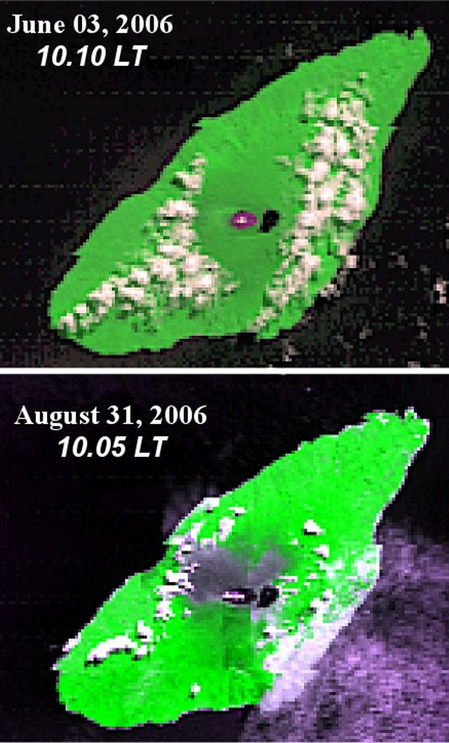 |
Figure 28. Satellite moderate resolution imaging spectroradiometer (MODIS) views of Aoba volcano summit lakes (Voui and Lakua). (a) A view taken at 1010 on 3 June 2006, before the last phase of gas emissions. (b) A view taken at 1005 on 31 August 2006 shows a large (15-20 km2) gray area around the lakes where the reflectance from vegetation has significantly decreased. Courtesy of Alain Bernard. |
When IRD scientists conducted a visit to Aoba in late November 2006 vegetation surrounding the crater lake had been recently defoliated (figure 29), with trees completely burned and dead, due to plumes of acidic gas and aerosols during June-August 2006. They also concluded that heavy rainfalls since September 2006 diluted the acidity of plumes. Occasional green spots seen during the November visit were where new growths of ferns and tree ferns had become established. The acid effects were more extensive than previously seen since the early 1990s. This new behavior may reflect increased degassing from the source vent inside the ring-shaped tephra (or tuff) cone.
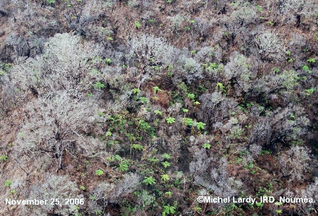 |
Figure 29. Aerial view of the vegetation downwind of Lake Voui at Aoba as of 25 November 2006. The scene was one of dead, completely defoliated trees. Courtesy of Michel Lardy, IRD. |
On 25 November 2006 an IRD team measured an SO2 flux of 3,000 tons/day. This value coincided with the measurement provided by the ozone monitoring instrument (OMI on the EOS Aura satellite). The value represented a marked reduction in SO2 degassing compared to that measured on 10 June 2006.
The team noted that the main lake in the crater, Lake Voui, was still a red color, an effect due to oxidation of the iron in its large mass of water (BGVN 31:05). Within that larger lake resides the ring-shaped island, which largely formed during the late 2005-early 2006 eruptions (BGVN 31:01). The island's form had been that of an unbroken ring, but by the time of their 25 November visit, the preceding month's heavy rains had eroded the smaller islands wall, allowing water in the two lakes to easily mix (figure 30). The W shore of Lake Voui has also been eroded, and fumaroles were observed in the lake. The breach in the tephra ring coincided with gas emissions ceasing.
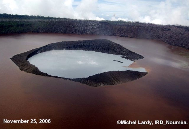 |
Figure 30. Aerial view of Lake Voui at Aoba as of 25 November 2006. The vent is now open to the lake and plume degassing stopped. Image courtesy of Michel Lardy, IRD. |
The IRD team implemented the first permanent real-time temperature monitoring during their visit. Due to the heavy rainfall since June 2006 and the lowered levels of evaporation associated with the lowered average lake temperature (~ 25°C on 25 November 2006), the lake level remained high. In addition, the average level of Lake Voui is higher due to volcanic material (ash, scoria) deposited between December 2005 and January 2006, and it should continue to fluctuate seasonally, as in the past.
Geological Summary. The island of Ambae, also known as Aoba, is a massive 2,500 km3 basaltic shield that is the most voluminous volcano of the New Hebrides archipelago. A pronounced NE-SW-trending rift zone with numerous scoria cones gives the 16 x 38 km island an elongated form. A broad pyroclastic cone containing three crater lakes (Manaro Ngoru, Voui, and Manaro Lakua) is located at the summit within the youngest of at least two nested calderas, the largest of which is 6 km in diameter. That large central edifice is also called Manaro Voui or Lombenben volcano. Post-caldera explosive eruptions formed the summit craters about 360 years ago. A tuff cone was constructed within Lake Voui (or Vui) about 60 years later. The latest known flank eruption, about 300 years ago, destroyed the population of the Nduindui area near the western coast.
Information Contacts: Michel Lardy, Institut de Recherche pour le Développement (IRD), BP A 5 98 848 Noumea Cedex, New Caledonia (URL: http://nouvelle-caledonie.ird.fr/); Department Geology Mines and Water Resources (DGMWR), Geohazard Section, PMB 01 Port-Vila, Republic of Vanuatu; Alain Bernard, Universite Libre de Bruxelles, Brussels, Belgium (URL: http://www.ulb.ac.be/sciences/cvl/aoba/Ambae1.html).