Report on Nyamulagira (DR Congo) — January 2007
Bulletin of the Global Volcanism Network, vol. 32, no. 1 (January 2007)
Managing Editor: Richard Wunderman.
Nyamulagira (DR Congo) October seismic swarm followed by the eruption of 27 November 2006
Please cite this report as:
Global Volcanism Program, 2007. Report on Nyamulagira (DR Congo) (Wunderman, R., ed.). Bulletin of the Global Volcanism Network, 32:1. Smithsonian Institution. https://doi.org/10.5479/si.GVP.BGVN200701-223020
Nyamulagira
DR Congo
1.408°S, 29.2°E; summit elev. 3058 m
All times are local (unless otherwise noted)
Jacques Durieux, the United Nations manager for Volcano Risk Reduction for the Goma Volcano Observatory (GVO), reported that at about 2000 on 26 October 2006 the observatory began to record sustained seismic activity. The activity took place in the Virunga area, located in the central part of Western arm of the East African rift valley. The swarm of long-period earthquakes was located around Nyamuragira and persisted for a month, through 1700 on 27 November 2006. The volcano was the scene of several seismic swarms in middle and late 2005 (BGVN 31:01).
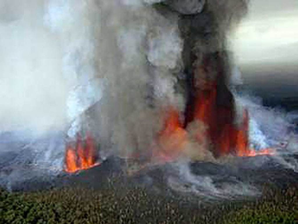
GVO observed the beginning of a new eruption at 2000 on 27 November 2006 (figure 26). Seen from ~ 30 km S of the volcano in Goma, the eruption site appeared to be located on the S flank; intense red glow suggested typical lava fountains and lava flows.
The local security situation prevented closer field observations. GVO was attempting to organize helicopter overflights to collect more information for updates. One concern was that foraging animals could fall ill after eating ash-coated vegetation. In assessing the situation, authorities considered Goma to be safe from any potential lava flows as Mount Nyiragongo would serve as a buffer.
Based on satellite imagery, the Toulouse VAAC reported that during 29 November-2 December 2006 emissions produced ash plumes to altitudes of 3-6.1 km. Those plumes drifted W and NW. By mid-morning on 2 December, ash plumes were no longer reported.
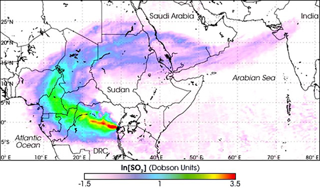
Besides ash and possible lava, the volcano also released extensive sulfur dioxide (SO2), a feature of this volcano that has been mentioned repeatedly in the literature (see some references below). The Ozone Monitoring Instrument (OMI) on NASA's Aura satellite tracked the emission of this gas from the volcano from 28 November to 4 December 2006 (figure 27). The SO2 gas was most concentrated around the eruption site and thinned as it moved away. The plume first traveled W, then curved along an arc progressing in a clockwise direction toward the NE and then E. It remained clearly detectable over NW India, a distance of ~ 9,000 km.
The latest eruption of Nyamuragira was its 15th since 1980. Table 2 shows OMI's estimated SO2 loadings during 28 November to 4 December 2006 as computed by Simon Carn. Carn also presented daily OMI images (like figure 27) during the same date range as table 2.
Table 2. Daily SO2 flux at Nyamuragira, measured by OMI during 28 November to 4 December 2006. Courtesy of Simon Carn.
| Date | Sulfur dioxide, Tg (tetragram = 1012 g) |
| 28 Nov 2006 | 0.21 |
| 29 Nov 2006 | 0.46 |
| 30 Nov 2006 | 0.68 |
| 01 Dec 2006 | 0.77 |
| 02 Dec 2006 | 0.78 |
| 03 Dec 2006 | 0.71 |
| 04 Dec 2006 | 0.59 |
| Total | 4.20 |
References. Carn, S.A., Bluth, G.J.S., and Head, E., (in progress), Virunga Volcanic SO2 Emissions Research (ViSOR) project (discussed at URL: http://userpages.umbc.edu/~scarn/virunga/).
Carn, S.A., 2004, Eruptive and passive degassing of sulfur dioxide at Nyiragongo volcano (D.R. Congo): the 17 January 2002 eruption and its aftermath: Acta Vulcanologica, v. 14-15, p. 75-86.
Carn, S.A., and Bluth, G.J.S., 2003, Prodigious sulfur dioxide emissions from Nyamuragira volcano, D.R. Congo: Geophys. Res. Lett., v. 30, no. 23, p. 2211, doi:10.1029/2003GL018465.
Bluth, G.J.S, and Carn, S.A., (in progress), Exceptional sulphur degassing from Nyamuragira volcano, 1979-2005: Int. J. Remote Sensing.
Tedesco, D., Vaselli, O., Papale, P., Carn, S.A., Voltaggio, M., Sawyer, G.M., Durieux, J., Kasereka, M., and Tassi, F., (in progress), The January 2002 Eruption of Nyiragongo volcano, Democratic Republic of Congo: J. Geophys. Res.
Geological Summary. Africa's most active volcano, Nyamulagira (also known as Nyamuragira), is a massive high-potassium basaltic shield about 25 km N of Lake Kivu and 13 km NNW of the steep-sided Nyiragongo volcano. The summit is truncated by a small 2 x 2.3 km caldera that has walls up to about 100 m high. Documented eruptions have occurred within the summit caldera, as well as from the numerous flank fissures and cinder cones. A lava lake in the summit crater, active since at least 1921, drained in 1938, at the time of a major flank eruption. Recent lava flows extend down the flanks more than 30 km from the summit as far as Lake Kivu; extensive lava flows from this volcano have covered 1,500 km2 of the western branch of the East African Rift.
Information Contacts: Jacques Durieux, Observatoire Volcanologique de Goma, Departement de Geophysique, Centre de Recherche en Sciences Naturelles, Lwiro, D.S. Bukavu, DR Congo; NASA, Earth Observatory Natural Hazards website (URL: http://earthobservatory.nasa.gov/NaturalHazards); Simon Carn, Joint Center for Earth Systems Technology (JCET), University of Maryland Baltimore County (UMBC), 1000 Hilltop Circle, Baltimore, MD, USA (URL: https://jcet.umbc.edu/); Toulouse Volcanic Ash Advisory Center (VAAC), Météo-France, 42 Avenue Gaspard Coriolis, F-31057 Toulouse cedex, France (URL: http://www.meteo.fr/vaac/).


