Report on Karthala (Comoros) — January 2007

Bulletin of the Global Volcanism Network, vol. 32, no. 1 (January 2007)
Managing Editor: Richard Wunderman.
Karthala (Comoros) Elevated seismicity followed by January 2007 eruption
Please cite this report as:
Global Volcanism Program, 2007. Report on Karthala (Comoros) (Wunderman, R., ed.). Bulletin of the Global Volcanism Network, 32:1. Smithsonian Institution. https://doi.org/10.5479/si.GVP.BGVN200701-233010
Karthala
Comoros
11.75°S, 43.38°E; summit elev. 2361 m
All times are local (unless otherwise noted)
Karthala, in the Comoros Islands (figure 28), was a scene of elevated seismicity from October 2006 to January 2007. The last time an eruption of Karthala caused significant damage was in the 1970s when it destroyed a village S of the capital, Moroni. Presently, Karthala is monitored using seismic and ground deformation surveys. The seismic activity that began 28 May 2006 (BGVN 31:07) appeared to have been a singular event. Renewed seismicity on 29 October 2006 prompted authorities to warn island residents that one of the two volcanoes on the main island of Grand Comore (Karthala or La Grille) could erupt within the next few weeks.
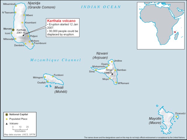 |
Figure 28. Map illustrating the regional setting of Karthala volcano in the Comoros Islands with comments relevant to the January 2007 crisis. Courtesy of ReliefWeb, a part of the United Nations Office for the Coordination of Humanitarian Affairs - Integrated Regional Information Networks (IRIN). |
Following earthquakes (which measured M 4 and larger on the Richter scale) that occurred on 12 January 2007, authorities again alerted the local population about hazards due to Karthala and activated a National Emergency Preparedness Plan. According to news reports, Hamidi Soule Saadi, director of the Karthala Volcano Observatory (KVO), warned that magma and gas were trapped inside the mountain.
According to a 15 January news article obtained from the ReliefWeb News, scientists from the KVO reported that an eruption occurred during the evening of 12 January. The news article noted Moroni residents observing jets of red flames above the summit (on the night of 12-13 January). A low eruptive tremor was detected 13 January and was accompanied by a number of M 4 earthquakes. An ash plume was observed above the volcano. Aerial observers on 15 January saw a lava lake forming within the crater.
The KVO said there was no immediate risk of a lava flow, and that there were three scenarios to consider: (1) seismic activity could decrease, reflecting diminished volcanic activity; (2) cracks or fissures could occur on the flanks, resulting in lava flowing down the side of the mountain; or (3) seismicity could intensify and increase lava production, which could flow over the crater rim. On 18 January, the volcano shook twice more but the tremors seemed to be weakening.
No evacuations of the island's 300,000 people occurred during the elevated seismicity; however, frightened residents were sleeping outside on football fields and in their gardens, fearing collapse of their homes. UN Resident Coordinator in the Comoros, Giuseppina Mazza, later reported that "There are now fewer earthquakes and their intensity has reduced, the population is not panicking."
The IRIN news article noted that volcanic activity is common to Grande Comoro Island. Karthala erupted twice in 2005, affecting 40,000 people in April and 175,000 more in November. After an eruption on 28 May 2006 (BGVN 32:07), volcanic dust and debris covered large areas of the island. Volcanic ash contaminated water supplies, raising concerns about the health of people and livestock, along with its effects on agriculture.
According to the UN Office for the Coordination of Humanitarian Affairs (OCHA), since the 12 January volcanic activity, the authorities kept the hazard status at "red alert" and "have activated the national emergency response preparedness plan. They established a crisis management cell (CMC) which includes government departments, UN agencies, the Comoros Red Crescent Society, as well as local NGOs and diplomatic missions ... [and the] partners are reviewing preparedness arrangements."
Geological Summary. The southernmost and largest of the two shield volcanoes forming Grand Comore Island (also known as Ngazidja Island), Karthala contains a 3 x 4 km summit caldera generated by repeated collapse. Elongated rift zones extend to the NNW and SE from the summit of the Hawaiian-style basaltic shield, which has an asymmetrical profile that is steeper to the S. The lower SE rift zone forms the Massif du Badjini, a peninsula at the SE tip of the island. Historical eruptions have modified the morphology of the compound, irregular summit caldera. More than twenty eruptions have been recorded since the 19th century from the summit caldera and vents on the N and S flanks. Many lava flows have reached the sea on both sides of the island. An 1860 lava flow from the summit caldera traveled ~13 km to the NW, reaching the W coast to the N of the capital city of Moroni.
Information Contacts: Hamidi Soule Saadi, Karthala Volcano Observatory (KVO), Observatoire Volcanologique du Karthala, Centre National de Documentation et de la Recherche Scientifique des Comores, BP 169 Moroni, République Fédérale Islamique des Comores; Giuseppina Mazza, UN Resident Coordinator in Comoros, BP 648, Moroni, Comoros; Hamidou Nassor, Université de la Réunion, BP 7151, 15 Avenue, René Cassin, 97715 Saint-Denis, La Réunion, France; United Nations Office for the Coordination of Humanitarian Affairs?Integrated Regional Information Networks (IRIN), 3rd Floor, Sandton 2146, PO Box 1617, Parklands, 2121, Johannesburg, Republic of South Africa; Reuters.