Report on Fukutoku-Oka-no-Ba (Japan) — January 2007
Bulletin of the Global Volcanism Network, vol. 32, no. 1 (January 2007)
Managing Editor: Richard Wunderman.
Fukutoku-Oka-no-Ba (Japan) Discolored water attributed to submarine volcanism
Please cite this report as:
Global Volcanism Program, 2007. Report on Fukutoku-Oka-no-Ba (Japan) (Wunderman, R., ed.). Bulletin of the Global Volcanism Network, 32:1. Smithsonian Institution. https://doi.org/10.5479/si.GVP.BGVN200701-284130
Fukutoku-Oka-no-Ba
Japan
24.285°N, 141.481°E; summit elev. -29 m
All times are local (unless otherwise noted)
Oliver Hyvernaud twice notified the Bulletin of Notice to Mariners reports of discolored sea water observed on 4 October and 15 November 2006 at about 24°17'N, 141°29'E. Both warnings referred to the same general location, encompassing an area of ocean 93 km SSW of Iwo Jima. In reality, the two positions noted below are ~ 1.3 km apart, perhaps overlapping each other. The warnings were as follows:
1) Discolored water with submarine volcanic activity reported within 1,700 m of 24°17.5' N, 141°29.4 E at 0400 UTC on 4 October 2006 [ref. Notice to Mariners, 14 October 2006 (no. 41), HYDROPAC Warning 1921/06(97) North Pacific, issued 1009 UTC on 4 October 2006].
2) Discolored water with submarine volcanic activity reported within 2,000 m of 24°17.1' N, 141°28.8 E at 0236 UTC on 15 November 2006 [ref. Notice to Mariners, 2 December 2006 (no. 48), HYDROPAC Warning 2225/06(97) North Pacific, issued 1133 UTC on 16 November 2006]
For the locations given for warnings 1 and 2, the respective deviations from coincidence with Fukutoku-Okanoba (at the coordinates given above) are 1.4 and 0.8 km. That seamount frequently produces discolored seawater and is known to erupt on occasions as well, and is thus the probable source for the discolored water.
According to the Japan Meteorological Agency, observations on 15 November 2006 by the Japan Maritime Self Defense Force and aerial observations on 21 November 2006 by the Japan Coast Guard revealed areas of discolored water on the sea surface above the volcano. Those cases seemed to be caused by volcanic activities.
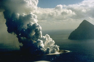
Geological Summary. Fukutoku-Oka-no-ba is a submarine volcano located 5 km NE of the island of Minami-Ioto. Water discoloration is frequently observed, and several ephemeral islands have formed in the 20th century. The first of these formed Shin-Ioto ("New Sulfur Island") in 1904, and the most recent island was formed in 1986. The volcano is part of an elongated edifice with two major topographic highs trending NNW-SSE, and is a trachyandesitic volcano geochemically similar to Ioto.
Information Contacts: Olivier Hyvernaud, Laboratoire de Géophysique, BP 640 Pamatai, Tahiti, French Polynesia; Notice to Mariners, National Geospatial-Intelligence Agency, National Ocean Service, and U.S. Coast Guard, Office of Corporate Relations, Public Affairs Division, MS D-54, 4600 Sangamore Road, Bethesda, MD 20816-5003, USA (URL: http://www.nga.mil/portal/site/maritime/); Japan Meteorological Agency, 1-3-4 Otemachi, Chiyoda-ku, Tokyo 100-8122, Japan (URL: http://www.jma.go.jp/).