Report on Home Reef (Tonga) — April 2007
Bulletin of the Global Volcanism Network, vol. 32, no. 4 (April 2007)
Managing Editor: Richard Wunderman.
Home Reef (Tonga) Island almost gone in mid-February; pumice reaches Australia
Please cite this report as:
Global Volcanism Program, 2007. Report on Home Reef (Tonga) (Wunderman, R., ed.). Bulletin of the Global Volcanism Network, 32:4. Smithsonian Institution. https://doi.org/10.5479/si.GVP.BGVN200704-243080
Home Reef
Tonga
18.992°S, 174.775°W; summit elev. -10 m
All times are local (unless otherwise noted)
The new island at Home Reef that was constructed by the 8-11 August 2006 felsic shallow marine explosive eruption (BGVN 31:09) was visited on 18 February 2007 by Scott Bryan (Kingston University, United Kingdom), Alex Cook (Queensland Museum, Australia), and Peter Colls (University of Queensland, Australia). The initial aim of field research was to map and describe the volcanic geology of the new island at Home Reef and to collect samples for comparison to floating pumice generated by the eruption (Bryan, 2007).
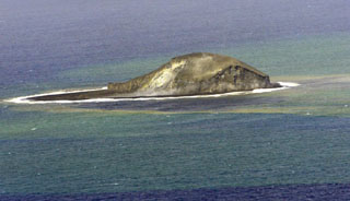
Island observations. Satellite imagery on 4 October 2006 showed an 800-m-long elongate island (0.23-0.26 km2), which was being rapidly modified by wave erosion (BGVN 31:10). An overflight by the RNZAF on 7 December 2006 revealed a roughly circular island, 450 m in diameter and up to 75 m above the water line (BGVN31:12). Upon arrival on 18 February 2007, the scientists found that only a small (50-75 m diameter) <5 m high low-relief wave-reworked "pumice mound" remained at the southern windward end of the Home Reef shoal (figure 23). Due to strong winds and large swells, landing on the tidally-exposed mound was not possible and it could only be viewed from a couple of hundred meters offshore. The location of the mound (18.993°S 174.758°W) is close to that reported for the circular island observed on 7 December 2006. Swells 2-m high or greater were strongly impacting the mound, with the largest waves almost completely engulfing and sweeping over the mound at half-tide.
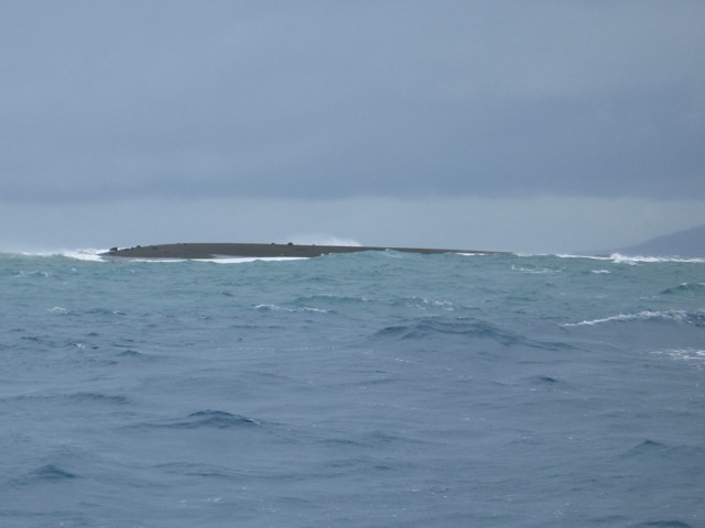 |
Figure 23. View to the NW of the wave-reworked pumice mound at Home Reef, as seen on 18 February 2007. The diameter of the mound is ~ 75 m. Note the scattered large blocks on the upper surface of the mound. Late Island is in the background at right. Courtesy of Scott Bryan. |
The morphology of the island suggests that no primary subaerial island-building deposits remain from the eruption and that complete reworking has occurred of the previously observed cone. On the southern side of the pumice mound were scattered large (>1 m diameter), outsized blocks (10-20 in number) on the mound surface (figure 23) that were largely immobile in the waves. Slopes of the mound reflected wave run-up and the pumiceous material comprising the mound appeared to be relatively coarse and well-sorted. There was little entrained particulate material in the water column downwind and downcurrent, but considerable amounts of material within the surf zone surrounding the island, coloring the water brown. A considerable area of discolored water (green, translucent milky) extended N of the mound for more than 500 m. Several smaller lobes or plumes extended off the W side of the main body of discoloration.
A strong sulfurous odor was detected downwind (NW) of the mound, indicating that magma was continuing to cool and degas at shallow levels in the seamount seven months after the eruption; no surface plume was visible. Surface water temperature measurements did not detect any thermal anomalies, recording ambient water temperatures (28-29°C).
Local pumice sightings. Downwind and downcurrent of the mound were small scattered pumice stringers forming orange-brown slicks a few meters to tens of meters long, characterized by low pumice clast abundance and size (usually 0.5-1 cm diameter). The pumice fragments were generally moderate to high sphericity grains, but some more platy pumice fragments were also sampled. Some clasts had orange to brown surface stains, reflecting hydrothermal alteration since the eruption. Most grains showed some signs of abrasion. Orange-brown algal clumps or coagulates floating on the ocean surface were associated with the stringers.
Small pumice rafts were also encountered around some of the islands at the SW end of the Vava'u Group during the week of 17-24 February (figure 24). The pumice rafts had lateral extents of tens of meters, but other flotsam (leaf, twig, sea grass and plastics) was also present. Pumice clast sizes ranged from ~ 2 mm up to 6 cm, and some of the gray pumice possessed orange-brown surface hydrothermal staining. Some rafts had abundant attached fauna, dominated bygoose barnacles (Lepas sp.) ~ 2-7 mm long. Much of these pumice rafts reflected remobilization of previously stranded material from neighboring beaches, and many SE-facing beaches had been stripped of pumice by strong SE trade winds.
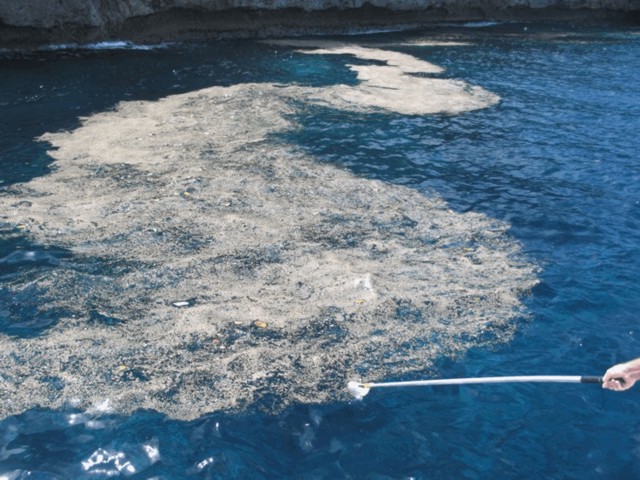 |
Figure 24. Pumice slick from Home Reef found on the W side of Nuatapu Island, 21 February 2007. Note other flotsam (leaves, plastic) within the slick. Courtesy of Scott Bryan. |
Many beaches had several pumice strandline deposits, the lowermost of which reflected tidal sorting. Dominantly lapilli-sized gray pumice formed the deposits, whereas a black glassy, moderately vesicular pumice of higher density was a notable feature of the highest strandlines. There were also abundant pumice clasts with an orange-brown staining on clast surfaces.
Floating pumice reaches Australia. Pumice rafts and beach strandings were reported previously as the pumice drifted westward past the Lau and Fiji islands and on to Vanuatu in November 2006. A major influx of pumice reached the E coast of northeastern Australia during March and April 2007, seven to eight months after the eruption. Pumice was first noticed passing the offshore islands of Willis Island (16.30°S, 149.98°E) in early February, and Lizard Island (14.66°S 145.47°E) the last week of February. Pumice strandings along the eastern Australian coast began in March in northern Queensland, with a substantial stranding occurring in mid-April corresponding to a change to easterly and northeasterly onshore wind conditions and king tides. This stranding event extended for more than 1,300 km along the Queensland and northern New South Wales coast.
Most stranded pumice clasts ranged in size from 1-4 cm diameter, with the largest clasts up to 17 cm diameter. Pumice clasts were fouled by a variety of organisms, primarily goose barnacles (Lepas sp.) up to 2.7 cm long, molluscs, bryozoa, and dark green algae (figure 25), with serpulids, oysters and other species of algae (e.g., Halimeda) less abundant. A substantial proportion of stranded pumice material remains on beaches inshore from the Great Barrier Reef. However, little stranded material has remained on exposed beaches south of 25°S, to the extent that some beaches still have more pumice preserved from the 2001 eruption of an unnamed Tongan seamount about 85 km NW of Home Reef.
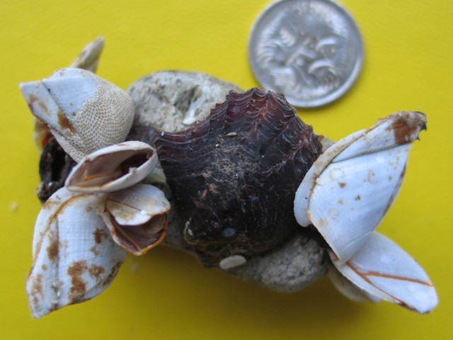 |
Figure 25. Closeup of a pumice clast from Home Reef that reached Marion Reef (19.095°S, 152.390°E), Australia, fouled by goose barnacles (Lepas sp.), bryozoa, and mollusc. Coin is 2 cm in diameter. Courtesy of Scott Bryan. |
Seismicity. Although no seismicity has been reported that was detected during the eruption, Robert Dziak identified seismic signals from Home Reef in March 2006. The East Pacific hydrophone array maintained by NOAA recorded 52 earthquakes over a 12-hour period beginning at 1700 UTC on 12 March 2006. The arrivals were all very clear and had medium to low T-wave amplitudes.
Reference. Bryan, S.E., 2007, Preliminary Report: Field investigation of Home Reef volcano and Unnamed Seamount 0403-091: Unpublished Report for Ministry of Lands, Survey, Natural Resources and Environment, Tonga, 9 p.
Geological Summary. Home Reef, a submarine volcano midway between Metis Shoal and Late Island in the central Tonga islands, was first reported active in the mid-19th century, when an ephemeral island formed. An eruption in 1984 produced a 12-km-high eruption plume, large amounts of floating pumice, and an ephemeral 500 x 1,500 m island, with cliffs 30-50 m high that enclosed a water-filled crater. In 2006 an island-forming eruption produced widespread dacitic pumice rafts that drifted as far as Australia. Another island was built during a September-October 2022 eruption.
Information Contacts: Scott Bryan, School of Earth Sciences & Geography, Kingston University, Kingston Upon Thames, Surrey KT1 2EL, United Kingdom; Peter Colls, School of Physical Sciences, University of Queensland, St Lucia, Queensland 4072, Australia; Robert Dziak, NOAA Pacific Marine Environmental Laboratory (PMEL), Hatfield Marine Science Center, 2115 SE Oregon State University Drive, Newport, OR 97365, USA.