Report on Santa Ana (El Salvador) — April 2007

Bulletin of the Global Volcanism Network, vol. 32, no. 4 (April 2007)
Managing Editor: Richard Wunderman.
Santa Ana (El Salvador) Lahars follow October 2005 eruptions; steam emissions
Please cite this report as:
Global Volcanism Program, 2007. Report on Santa Ana (El Salvador) (Wunderman, R., ed.). Bulletin of the Global Volcanism Network, 32:4. Smithsonian Institution. https://doi.org/10.5479/si.GVP.BGVN200704-343020
Santa Ana
El Salvador
13.853°N, 89.63°W; summit elev. 2381 m
All times are local (unless otherwise noted)
Our last report (BGVN 31:01) discussed post-eruption lahars following the sudden 1 October 2005 eruption (BGVN 30:09). This report contains two sections. The first section addresses regional processes such as vegetation loss, ash accumulation, and lahars on and beyond the E flank of Santa Ana (also known as Ilamatepec) to the shores of Lake Coatepeque. Those lahars began soon after the 1 October 2005 eruption. The information on these lahars chiefly came from a report (SNET, 2006) authored by El Salvador's Servicio Nacional de Estudios Territoriales (SNET).
The second section addresses monitoring and observations such as extensive steaming and drop in the surface elevation of the lake in the summit crater. Material for this section, primarily found on the SNET website, covers January-April 2006, when activity was fumarolic with no large eruptions. The 1 October 2005 eruption was possibly followed by a second one two days later on 3 October (SNET, 2006). A 3 October eruption was not mentioned in previous Bulletin reports.Carlos Pullinger explained that the evidence for the second eruption was tremor that day, but that could stemmed from other causes such as geysers in the summit crater lake, so the evidence for a 3 October eruption remains equivocal.
E-flank issues. October 2005 volcanism took place coincident with unusually high rains during tropical storm Stan (1-10 October 2005). On the E flank, the October 2005 eruptive episode killed extensive vegetation and left loose ash deposits covering the upper slopes (figure 7).
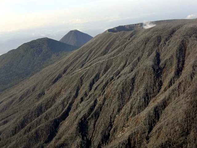 |
Figure 7. A November 2005 photo looking southward showing Santa Ana in the foreground, along with denuded, ash-laden vegetation. A wisp of steam escapes the summit crater, a basin hosting an acidic crater lake. Santa Ana's plumes and October 2005 ash deposits, coupled with other factors such as steep slopes, stress to vegetation, the lack of surviving permeable soils, and regional rainfall have led to a rash of new E-flank lahars. Peaks beyond Santa Ana include its satellitic cone Cerro Verde and then Izalco (sharp peak beyond the notch). Photo from SNET (2006). |
Based on a rain gauge 5 km W of the crater (national meteorological station Los Naranjos), rainfall in October averages 193 mm; the yearly average is 2,155 mm. In the months prior to October 2006, rainfall at that station remained at normal values, always below 460 mm per month. In contrast, rainfall reached 865 mm during October 2006. During the peak of the storm, 3-6 October 2005, the Los Naranjos rain gauge collected more than 100 mm per day; the highest reading of 320 mm was on 5 October.
The lahars on Santa Ana's E slope consisted of both material from the October 2005 eruption as well as previous deposits. The first lahar seen by local witnesses took place on the night of 2 October 2005. It carried material up to 2 m in diameter. The lahars that produced most of the damage were those that occurred immediately after the eruption and reached a maximum thickness of 1.5 m. Other lahars descended later in the storm, persisting well into 2006.The 2006 rainy season did not generate damaging lahars, just heavy runoff with minor sediment. In all, SNET seismically registered 22 lahar events, all of which were confirmed by local residents. The communities used tractors used to keep the main drainages open and to build levees, which confined the lahars inside main drainage areas. The SNET website mentioned several lahar episodes during 2006. Some of these episodes occurred in May, June, and July 2006.
A large scallop in the topographic margin of Coatepeque caldera results in Planes de la Laguna (an area of ~ 10 km2), which was where lahars eventually deposited (figures 8 and 9). This area of less steeply sloped, and in places comparatively level, ground contains numerous coffee plantations and small settlements. The largest settlement is El Javillal (figure 8, adjacent Lake Coatepeque).
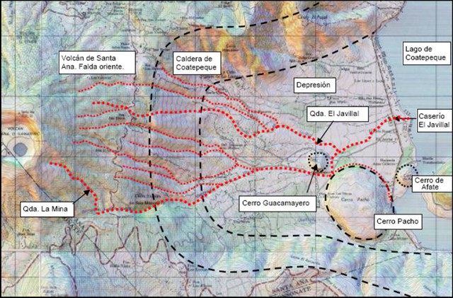 |
Figure 8. Lahars displayed as trains of heavy dots on a topographic base map of the E-central side of Santa Ana and the adjacent W side of Lake Coatepeque. (N is towards the top; light grid-lines are 1 km apart, so the distance from the summit on the W to the large lake on the E is ~ 6.5 km.) In general, the lahars descended from W to E. Coatepeque is a 7 x 10 km caldera and the series of dashed lines across the map indicate the caldera's steep-sided topographic margin in. Several caldera domes are labeled, including Cerro Pacho and Cerro Afate. Note the lahar entering the settlement adjacent Lake Coatepeque ("Caserío El Javillal"). From SNET (2006). |
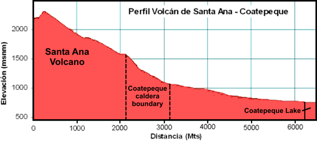 |
Figure 9. An E-W topographic profile with Santa Ana on the W across to the E side of Lake Coatepeque on the E. Dashed lines indicate the location of Coatepeque's caldera wall. From SNET (2006). |
The upslope areas contained numerous channels carrying lahars (figure 8). Several kilometers into the caldera the channels merge as they cross the less steeply sloped Planes de Laguna. The channels eventually grow into two primary channels, La Mina on the S and El Javillal on the N (figure 10). The La Mina channel led directly towards the Cerro Pacho dome, where the lahars proceeded to branch into multiple routes (A, B, C, and D) before entering El Javillal (figure 11).
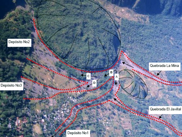 |
Figure 10. Annotated aerial photo at unknown date showing part of Coatepeque's Planes de Laguna, W of Santa Ana, taken looking roughly S. The view illustrates lahars in and around El Javillal.The lahars entered the area along two drainages (Quebradas La Mina and El Javillal), both flowing from right to left (arrows). Adjacent to the domes and settlements, the flow patterns become quite complex (as indicated by flow directions A, B, C, and D). Lake Coatepeque appears at the upper left. The steep caldera wall lies along the photo's margin from the upper center to right corner. The large circular dome is Cerro Pacho; the smaller dome to the right is Cerro Guacamayero. Photo from SNET (2006). |
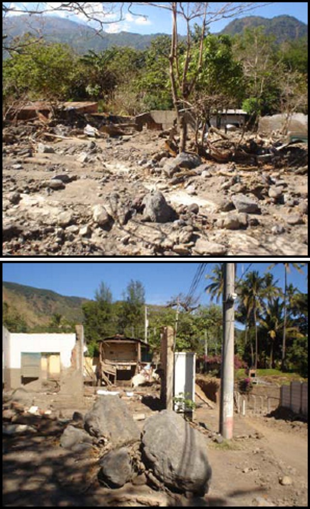 |
Figure 11. Photos showing October 2005 lahar deposits from Santa Ana in El Javillal. Deposits included lava blocks of differing sizes, and a mixture of soil, tree parts, mud, and water. Photos from SNET (2006). |
Given the lack of soils and the state of vegetation, lahars were viewed as a potential ongoing hazard. To control lahars, SNET (2006) proposed excavating two channels from the vicinity of the domes to Lake Coatepeque, to carry sediment farther towards the lake. The proposed artificial channels are 2 m deep, with sides that slope at 45° outwards, and with a flat floor 5 m across. One proposed channel follows the S margin of the Cerro Pacho dome, the other follows a path similar to arrow A on figure 10.
Pullinger noted that the jocote de corona crop harvest was not affected because it came out just after the eruption. However, coffee was damaged wherever ash fell. Lahars did not directly hurt coffee plantations, but access roads were damaged and labor for harvesting was minimal, after much of the population had fled.
Monitoring. Moderate seismic activity and steam emissions continued during 2006. During 2006, seismicity was slightly above normal levels. Small earthquakes were interpreted as being associated with gas pulses.
Degassing continued in January 2006 with sporadic gas-and-steam emissions which rose approximately 200 m before dispersing. The SO2 flux ranged between 163 and 1,578 metric tons/day.
On 2 February, there was an increase in seismicity, possibly related to an earthquake on the coast of Guatemala. From 1-7 February the SO2 flux averaged 2,000 metric tons per day. A drop in the water level of the steaming, green-colored acidic lake in the summit crater revealed a local topographic high in the lake's center, which took the form of an irregular island (figure 12).
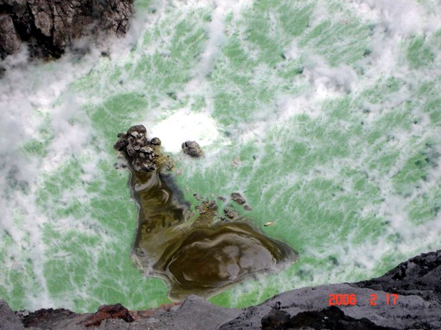 |
Figure 12. Photo showing the crater lake at Santa Ana volcano. The decrease in the water level has revealed an island of rocks and sediments that was previously covered by the crater lake. Photo taken on 17 February 2006 and provided courtesy of SNET. |
Intense bubbling and fumarole activity during 27 February-23 March disturbed the lake's surface and made it difficult to assess the level of the water. During April, instability in the crater led to periodic landslides. One significant landslide deposited material in the SW section of the beach of the crater lake.
Reference. Servicio Nacional de Estudios Territoriales (SNET), 2006, Flujos de escombros en la Ladera Oriente del Volcán Ilamatepec, Departamento de Santa Ana: Perfil de Obras de Mitigacion, Enero de 2006, 12 p.
Geological Summary. Santa Ana (also known as Ilamatepec), is a massive, dominantly andesitic-to-trachyandesitic stratovolcano in El Salvador immediately W of Coatepeque Caldera. Collapse during the late Pleistocene produced a voluminous debris avalanche that swept into the Pacific Ocean, forming the Acajutla Peninsula. Reconstruction of the volcano subsequently filled most of the collapse scarp. The broad summit is cut by several crescentic craters, and a series of vents and cones have formed along a 20-km-long fissure system that extends from near the town of Chalchuapa NNW of the volcano to the San Marcelino and Cerro la Olla cinder cones on the SE flank. Small to moderate explosive eruptions from both summit and flank vents have been documented since the 16th century. The San Marcelino cinder cone on the SE flank produced a lava flow in 1722 that traveled 13 km E.
Information Contacts: Carlos Pullinger, Servicio Nacional de Estudios Territoriales (SNET), Alameda Roosevelt y 55 Avenida Norte, Edificio Torre El Salvador, Quinta Planta, San Salvador, El Salvador (URL: http://www.snet.gob.sv).