Report on Mayon (Philippines) — May 2007
Bulletin of the Global Volcanism Network, vol. 32, no. 5 (May 2007)
Managing Editor: Edward Venzke.
Mayon (Philippines) Eruption ends on 1 October 2006; typhoon causes deadly lahars
Please cite this report as:
Global Volcanism Program, 2007. Report on Mayon (Philippines) (Venzke, E., ed.). Bulletin of the Global Volcanism Network, 32:5. Smithsonian Institution. https://doi.org/10.5479/si.GVP.BGVN200705-273030
Mayon
Philippines
13.257°N, 123.685°E; summit elev. 2462 m
All times are local (unless otherwise noted)
The eruption from Mayon that began on 13 July 2006 (BGVN 31:07) ended in early October. By mid-September 2006, the volcano's eruptive vigor had decreased (BGVN 31:08). According to reports by the Philippine Institute of Volcanology and Seismology (PHIVOLCS) through 3 October, low-frequency harmonic tremor was not recorded after 24 September, crater glow was last seen on 27 September, and tremor episodes were not detected after 30 September. Sulfur-dioxide flux was also low on 26 September, 1,200 metric tons per day (t/d), but could not be measured the following week due to poor weather. On 3 October PHIVOLCS noted that there had been a continuous decline in overall activity since 11 September. Lava extrusion apparently ceased on 1 October 2006, as reported by the Ligñon Hill Observatory. As a result, the hazard status was lowered to Alert Level 2, indicating that the possibility of a hazardous eruption was remote.
Fumarolic activity on 30 September and 1 October produced white steam plumes that drifted ENE. On 11 and 12 October steaming was moderate and one volcanic earthquake was recorded. During the first week of October, six low-frequency volcanic earthquakes and one low-frequency short duration harmonic tremor were recorded. Crater glow was seen again on 4 October. The SO2 flux measured on 6 October remained low at 1,600 t/d.
On 25 October, PHIVOLCS announced the lowering of the hazard status to Alert Level 1. The 7-km Extended Danger Zone on the SE flank remained in effect. At that time the number of daily volcanic earthquakes was below background levels (1-5 per day), tremor episodes were rare, there was no ground deformation, SO2 emission was within the typical 1,600-2,650 t/d range, and the observed glow remained at a consistent intensity.
Lahars caused by tropical storm. Typhoon Durian, also called Reming, struck the Philippines on 30 November and mobilized material from the flanks of Mayon that resulted in significant lahars, burying thousands of homes under 1.5 m of volcanic debris, mud, and flood waters. Official government information releases as of 13 December noted that the torrential rains and mudslides, particularly in the area of Mayon, killed 720 people, injured 2,360 others, and left 762 people missing. In addition, 328,218 houses were partially damaged and 214,400 houses were destroyed. A map produced by the United Nations Institute for Training and Research (UNITAR) Operational Satellite Applications Programme (UNOSAT) indicated that about 51 km2 on the flanks of Mayon was damaged by the flooding and mudslides.
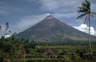
Geological Summary. Symmetrical Mayon, which rises above the Albay Gulf NW of Legazpi City, is the most active volcano of the Philippines. The steep upper slopes are capped by a small summit crater. Recorded eruptions since 1616 CE range from Strombolian to basaltic Plinian, with cyclical activity beginning with basaltic eruptions, followed by longer periods of andesitic lava flows. Eruptions occur predominately from the central conduit and have also produced lava flows that travel far down the flanks. Pyroclastic density currents and mudflows have commonly swept down many of the approximately 40 ravines that radiate from the summit and have often damaged populated lowland areas. A violent eruption in 1814 killed more than 1,200 people and devastated several towns.
Information Contacts: Philippine Institute of Volcanology and Seismology (PHIVOLCS), University of the Philippines Campus, Diliman, Quezon City, Philippines (URL: http://www.phivolcs.dost.gov.ph/); Associated Press (URL: http://www.ap.org/); Agence France-Presse (URL: http://www.afp.com/); United Nations Institute for Training and Research (UNITAR) Operational Satellite Applications Programme (UNOSAT), Palais des Nations, CH - 1211 Geneva 10, Switzerland (URL: http://www.unosat.org/); United Nations Office for the Coordination of Humanitarian Affairs (OCHA) (URL: https://reliefweb.int/).

