Report on Chikurachki (Russia) — May 2007
Bulletin of the Global Volcanism Network, vol. 32, no. 5 (May 2007)
Managing Editor: Edward Venzke.
Chikurachki (Russia) Ash plumes during March and April 2007; ashfall and an SO2 cloud
Please cite this report as:
Global Volcanism Program, 2007. Report on Chikurachki (Russia) (Venzke, E., ed.). Bulletin of the Global Volcanism Network, 32:5. Smithsonian Institution. https://doi.org/10.5479/si.GVP.BGVN200705-290360
Chikurachki
Russia
50.324°N, 155.461°E; summit elev. 1781 m
All times are local (unless otherwise noted)
Several ash plumes, weak fumarolic activity, and ashfall occurred during March and April 2005 (BGVN 31:03). No further activity was reported until 4 March 2007, when weak ash explosions from Chikurachki were reported by residents of Podgorny, about 20 km ESE on Paramushir Island (figure 4). Chikurachki is not monitored with seismic instruments, so the Kamchatkan Volcanic Eruption Response Team (KVERT) relies on satellite data and occasional visual observations.
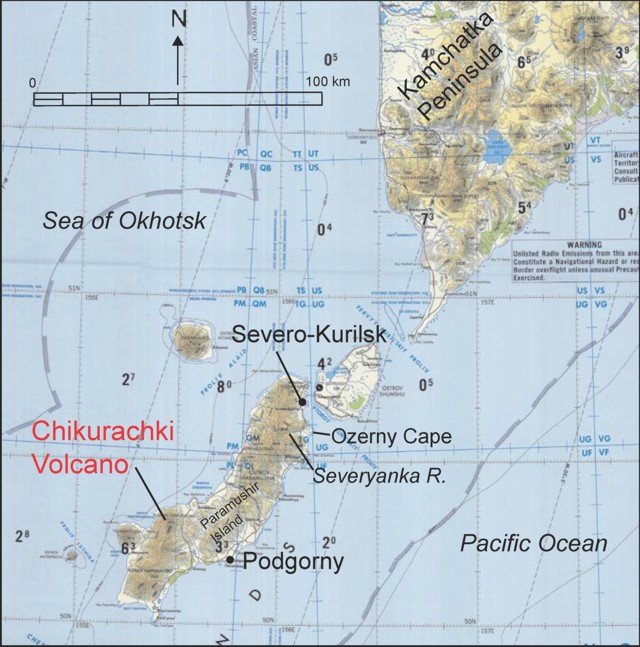 |
Figure 4. Map of the northern Kurile Islands and southern portion of Kamchatka Peninsula. From National Oceanic and Atmospheric Administration Tactical Pilotage Chart ONC-E10C, as provided by McGimsey and others (2005). |
On 5 March 2007, observers reported that a continuous ash column reached an altitude of 3.4 km. Ash plumes were also observed by satellite imagery during 11-12 March, 4-5 April, 9 April, 14-16 April, and 18 April. On 4 April, ashfall was noted at Severo-Kurilsk, 62 km NE. Hunters near the volcano observed bursts of volcanic bombs on 15 April. Satellite data analysis provided by the Volcanic Emissions Group at the University of Maryland Baltimore County revealed a sulfur dioxide cloud on 16 March 2007 extending 580 km NW at an unknown altitude.
According to KVERT, no eruptive activity has been noted since about 20 April. The concern color code was reduced from Orange to Yellow during the week of 20 April, and then to Green (lowest risk) during the week of 11 May.
Reference. McGimsey, R.G., Neal, C., and Girina, O., 2005, 2003 volcanic activity in Alaska and Kamchatka summary of events and response of the Alaska Volcano Observatory: U.S. Geological Survey report 2005-1310, http://pubs.usgs.gov/of/2005/1310.
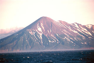
Geological Summary. Chikurachki, the highest volcano on Paramushir Island in the northern Kuriles, is a relatively small cone constructed on a high Pleistocene edifice. Oxidized basaltic-to-andesitic scoria deposits covering the upper part of the young cone give it a distinctive red color. Frequent basaltic Plinian eruptions have occurred during the Holocene. Lava flows have reached the sea and formed capes on the NW coast; several young lava flows are also present on the E flank beneath a scoria deposit. The Tatarinov group of six volcanic centers is located immediately to the south, and the Lomonosov cinder cone group, the source of an early Holocene lava flow that reached the saddle between it and Fuss Peak to the west, lies at the southern end of the N-S-trending Chikurachki-Tatarinov complex. In contrast to the frequently active Chikurachki, the Tatarinov centers are extensively modified by erosion and have a more complex structure. Tephrochronology gives evidence of an eruption around 1690 CE from Tatarinov, although its southern cone contains a sulfur-encrusted crater with fumaroles that were active along the margin of a crater lake until 1959.
Information Contacts: Olga Girina, Kamchatka Volcanic Eruptions Response Team (KVERT), a cooperative program of the Institute of Volcanic Geology and Geochemistry, Far East Division, Russian Academy of Sciences, Piip Ave. 9, Petropavlovsk-Kamchatsky, 683006, Russia; Alaska Volcano Observatory (AVO), a cooperative program of the U.S. Geological Survey, 4200 University Drive, Anchorage, AK 99508-4667, USA (URL: http://www.avo.alaska.edu/); Tokyo Volcanic Ash Advisory Center, Tokyo, Japan (URL: http://ds.data.jma.go.jp/svd/vaac/data/); Volcanic Emissions Group, based in the Joint Center for Earth Systems Technology at the University of Maryland Baltimore County and NASA Goddard Space Flight Center, 1000 Hilltop Circle, Baltimore, MD 21250, USA (URL: https://so2.gsfc.nasa.gov/).