Report on Tinakula (Solomon Islands) — July 2007
Bulletin of the Global Volcanism Network, vol. 32, no. 7 (July 2007)
Managing Editor: Richard Wunderman.
Tinakula (Solomon Islands) Thermal anomalies suggest eruption, but field observations absent
Please cite this report as:
Global Volcanism Program, 2007. Report on Tinakula (Solomon Islands) (Wunderman, R., ed.). Bulletin of the Global Volcanism Network, 32:7. Smithsonian Institution. https://doi.org/10.5479/si.GVP.BGVN200707-256010
Tinakula
Solomon Islands
10.386°S, 165.804°E; summit elev. 796 m
All times are local (unless otherwise noted)
MODIS thermal anomaly data for Tinakula (table 3) suggests continuing eruptive activity during the period mid-April through mid-July 2007, but no validation by field observations has become available. Similar intermittent anomalies have been detected since mid-February 2006 (BGVN 31:03 and 32:03).
Table 3. MODIS/MODVOLC thermal anomalies at Tinakula for mid-April through mid-June 2007 (continued from table in BGVN 32:03); note particularly the anomalies recorded on 11 July 2007. Courtesy of the University of Hawai'i Institute of Geophysics and Planetology (HIGP) MODIS Hotspot Alert website.
| Date | Time (UTC) | Pixels | Satellite |
| 12 Apr 2007 | 1420 | 1 | Aqua |
| 17 Apr 2007 | 1140 | 1 | Terra |
| 19 Apr 2007 | 1425 | 1 | Aqua |
| 03 May 2007 | 1440 | 2 | Aqua |
| 05 May 2007 | 1125 | 1 | Terra |
| 05 May 2007 | 1425 | 1 | Aqua |
| 10 May 2007 | 1145 | 2 | Terra |
| 10 May 2007 | 1445 | 2 | Aqua |
| 15 May 2007 | 1200 | 1 | Terra |
| 18 Jun 2007 | 1150 | 2 | Terra |
| 27 Jun 2007 | 1145 | 1 | Terra |
| 27 Jun 2007 | 1445 | 1 | Aqua |
| 29 Jun 2007 | 1130 | 1 | Terra |
| 11 Jul 2007 | 1155 | 4 | Terra |
| 11 Jul 2007 | 1455 | 4 | Aqua |
| 13 Jul 2007 | 1145 | 1 | Terra |
Several photographs were taken offshore of the island during the February 2006 eruption (BGVN 31:03); figure 6 is an example of some activity during that eruption.
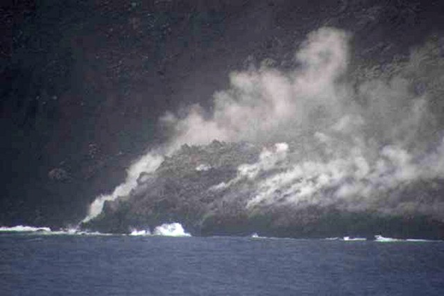 |
Figure 6. Lava blocks tumbling into the ocean on at Tinakula on the morning of 21 February 2006. Courtesy of Bill Yeaton. |
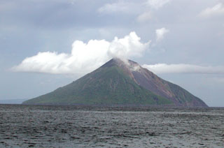
Geological Summary. The small 3.5-km-wide island of Tinakula is the exposed summit of a massive stratovolcano at the NW end of the Santa Cruz islands. It has a breached summit crater that extends from the summit to below sea level. Landslides enlarged this scarp in 1965, creating an embayment on the NW coast. The Mendana cone is located on the SE side. The dominantly andesitic volcano has frequently been observed in eruption since the era of Spanish exploration began in 1595. In about 1840, an explosive eruption apparently produced pyroclastic flows that swept all sides of the island, killing its inhabitants. Recorded eruptions have frequently originated from a cone constructed within the large breached crater. These have left the upper flanks and the steep apron of lava flows and volcaniclastic debris within the breach unvegetated.
Information Contacts: Hawai'i Institute of Geophysics and Planetology (HIGP) Thermal Alerts System, School of Ocean and Earth Science and Technology (SOEST), Univ. of Hawai'i, 2525 Correa Road, Honolulu, HI 96822, USA (URL: http://modis.higp.hawaii.edu/); Bill Yeaton (URL: http://www.billyeaton.com/).