Report on Uzon (Russia) — July 2007
Bulletin of the Global Volcanism Network, vol. 32, no. 7 (July 2007)
Managing Editor: Richard Wunderman.
Uzon (Russia) Valley of Geysers struck by large destructive landslide and related flood
Please cite this report as:
Global Volcanism Program, 2007. Report on Uzon (Russia) (Wunderman, R., ed.). Bulletin of the Global Volcanism Network, 32:7. Smithsonian Institution. https://doi.org/10.5479/si.GVP.BGVN200707-300170
Uzon
Russia
54.4885°N, 159.9741°E; summit elev. 1617 m
All times are local (unless otherwise noted)
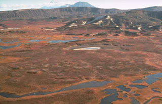
On 3 June 2007 the renowned Valley of Geysers in Kamchatka was seriously damaged by direct burial and subsequent flooding associated with a major landslide. This was communicated in a report from 28 June by the father-and-son team of Vladimir and Andrei Leonov. The Valley of Geysers is a remote geothermal area along a 4-km-long valley near the E margin of Geyzernaya caldera at Uzon-Geyzernaya volcano-tectonic depression ("U"; Leonov and others, 1991) (figure 1).
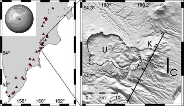 |
Figure 1. Maps showing Uzon-Geysernaya volcano-tectonic depression on the Kamchatka Peninsula, Russia. (left) Index map of the Kamchatka Peninsula, in the NW Pacific area, showing Holocene volcano locations. (right) Shaded relief map highlighting the topographic margins of the Uzon-Geysernaya volcano-tectonic depression ("U") and the Kikhpinych stratovolcano ("K"), one of the youngest in Kamchatka's eastern volcanic zone; the hachured line indicates the SE side of a regional graben. "Ic" indicates the center of inflation. World inset location map courtesy of NASA Earth Observatory. Main maps are from Lundgren and Lu (2006), but the right map was revised by Bulletin editors to add the location and Ic symbol based on interferograms in that paper. |
Although the name Uzon is entrenched in the literature, the shorthand is potentially confusing since it could refer to the caldera on the W side of the complex. Both Uzon and Geyzernaya calderas support hydrothermal systems feeding thermal features. Moreover, a small cone named Uzon resides on the W rim of Uzon caldera. Accordingly, in this report we will refer to the larger complex as Uzon-Geyzernaya. The landslide which entered the Valley of Geysers is refered to as the 2007 Geyzernaya landslide.
The area where the slide occurred was the subject of a recent paper (discussed below) on satellite-detected uplift on the same E side of the caldera where the slide took place (Lundgren and Lu, 2006). "Ic" indicates the approximate center of inflation detected by satellite radar interferometry using data from 2000 to 2003 (Lundgren and Lu, 2006 ).
According to the Leonovs' report, several beautiful geysers have been lost, including Pervenets, the first geyser discovered by Tatyana Ustinova in 1941, and a group of geysers known as Troynoy group. The main geyser field, Vitrazh, and the largest geyser, Velikan, remained intact (table 1 and figure 2).
Table 1. Summary and key to names and numbers for Valley of Geysers, about half of which were disrupted or destroyed by the 2007 Geyzernaya landslide. The numbers correspond with those on figures 2 and 3. Courtesy of Vladimir and Andrei Leonov.
| Number | Status | Name | English translation of name |
| 1 | Covered by slide | Pervenets | First born |
| 2 | Covered by slide | Troynoi | Triple |
| 3 | Covered by slide | Sakharny | Sugar |
| 4 | Covered by slide | Sosed | Neighbor |
| 5 | Covered by slide | Uvodopada | Near the waterfall |
| 6 | Flooded by lake | Skalisty | Rocky |
| 7 | Flooded by lake | Konus | Cone |
| 8 | Flooded by lake | Bolshaya Pechka | Gross Owen |
| 9 | Flooded by lake | Maly | Lesser |
| 10 | Flooded by lake | Bolshoi | Greater |
| 11 | Active mid-Sep | Shchel | Crack |
| 12-16 | Active on 28 Jun | "Vitrazh" geyser field: Grot, Novy Fontan, Fontan, Dvoynoi, Nepostoyanny | "Stained glass" geyser field: Grotto, New Fountain, Fountain, Double, Unstable |
| 17 | Active on 28 Jun | Velikan | Giant |
| 18 | Active on 28 Jun | Zhemchuzhny | Pearl |
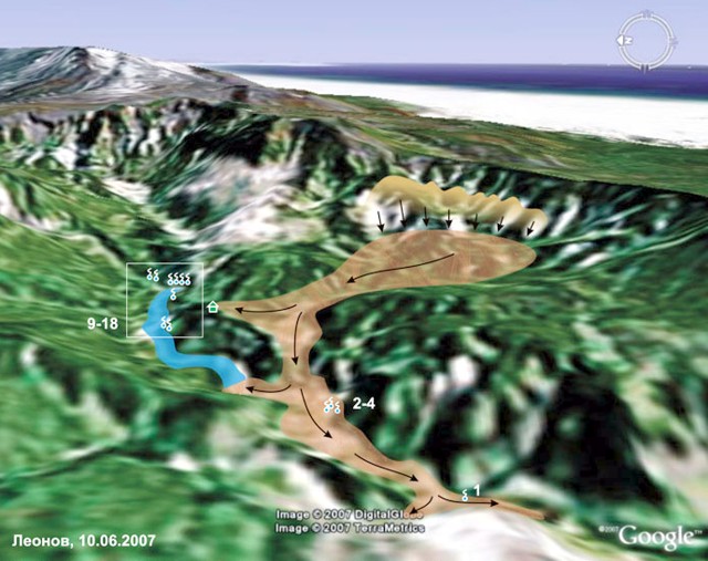 |
Figure 2. An oblique aerial view created on a base map from Google Earth software, depicting the Valley of Geysers looking E (N is to the left). The slide area and direction of flow are clearly marked, the mass having swept down the caldera's E wall. The topographically flat area in the upper right is the Pacific ocean. Note lodge at small icon in the form of a house. Thermal features indicated by symbol for spring (small circles with tail); many of these are numbered. The image also shows where the slide dammed the Geyzernaya river; the resulting lake submerged the Bolshoi and Maly geysers. Courtesy of Vladimir and Andrei Leonov. |
The landslide formed in the upper reaches of Vodopadny creek. The authors suggested that the main cause of the slide appeared to be the common process of gradual erosion. The nearest seismic instrument was ~ 100 km away; on that instrument at the time of the slide's onset, earthquakes were absent.
Correspondence with Vladimir Leonov on 11 September revealed that the slide's computed volume was then considered to be 12-15 million cubic meters. The report also stated that this was clearly the largest historical slide in Kamchatka and possibly one of the largest in all of Russia. Later correspondence clarified this comparison as excluding debris-avalanche deposits such as those associated with lateral blasts closely associated with eruptions in 1980 at St. Helens and in 1956 at Bezymianny.
The landslide of rock and mud went down the Vodopadny creek, reached the Geyzernaya river, and moved along the river to its inflow into the Shumnaya river (figures 2-4). The slide was ~ 2 km in length. A dam was formed on the Geyzernaya river with a height of up to 60 m that caused a rapid backup of water and the formation of a lake. The lake flooded the geysers Bolshoi and Maly located up the river and came close to the main "Vitrazh" geyser field. On 7 June the water level in the lake reached its maximum elevation of 435 m. Later that day the river eroded through the dam and the water level started to decline quickly. During the first four hours the water level subsided to 9 m depth. As of 28 June the main group of geysers appeared safe from flooding.
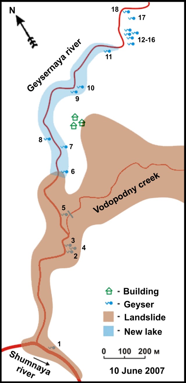 |
Figure 3. Sketch map on 10 June 2007 showing features after the Geyzernaya landslide. N is to the upper right. The numbers correspond to those on table 1. Courtesy of Vladimir and Andrei Leonov. |
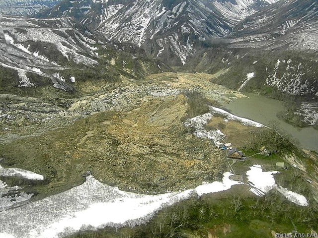 |
Figure 4. A photo looking down at the 2007 landslide from the NE rim of the Valley of Geysers. The lower portion of the landslide dammed the Geyzernaya river and backed up a lake. A surviving cluster of tourist facilities are at the slide's margin. From the Leonov's report; copyrighted photo by I.F. Delemen, Institute of Volcanology and Seismology, Far Eastern Branch of Russian Academy of Sciences (IVaS FEB RAS). |
In the flooding of the Bolshoi and Maly geysers, Bolshoi ended up 2 m under water, and Maly, 15 m under water. In addition, several smaller geysers?Skalisty (Rocky), Konus (Cone), Bolshaya Pechka (Gross Owen)?were also flooded. The pulsating spring Malakhitovy Grot (Malachite Grotto) was half-flooded and sometimes boiled.
On 7 June a new geyser appeared in the Valley but it was active for only several hours. While the water level in the lake increased, a pulsating spring in front of Shchel geyser (perhaps The Little Prince) started to work as a geyser with eruption heights of 4-5 m. After the water level dropped, the geyser returned to a pulsating spring state.
One of the landslide's tongues came close to tourist-camp buildings in the Geyser Valley (figures 2-6). Although some camp facilities were destroyed, three main houses (a hostel, a scientist's house, and a ranger's house) were undamaged. As seen in figures 5 and 6, the edge of the slide reached within about a meter of the hostel and covered parts of the adjacent wood-decked walkway. People occupied buildings when the landslide occurred but the slide halted at a point where no one was injured.
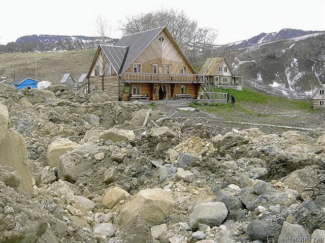 |
Figure 5. The landslide in the Valley of Geysers left the hostel at the tourist camp just barely outboard of the deposit. The juxtaposition of the deposit and unscathed building reveals the deposit's unsorted character and clast-size distribution, which includes some large blocks several meters in diameter. This photo was shot from ten's of meters away from the hostel. Photo is from the Leonov's report; copyrighted by I.F. Delemen (IVaS FED RAS). |
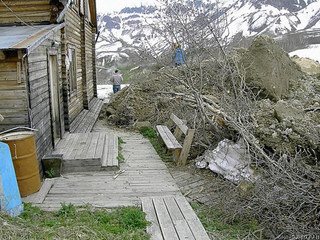 |
Figure 6. Landslide rubble came to rest near the hostel's side wall. From the Leonov's report; copyrighted photo by I.F. Delemen (IVaS FED RAS). |
At the time of the slide, a tourist group consisting of over 20 people were in the Valley, but fortunately they were at the thermal field near the river, and only helicopter pilots and some personnel remained at the camp. In addition to stopping near the buildings, the body of the lanslide stopped 1 m before the resting helicopter, but trees carried by the slide jutted out and entangled the helicopter.
The 30-m waterfall at the Vodopadny creek junction with Geyzernaya river was fully covered as well as the geyser near the waterfall. The "Thirty-meter rocks" at the entrance to the Geyser Valley were also covered by the landslide. All the small geysers, springs and thermal fields along Vodopadny creek were lost; however, the creek itself established a new course on the slide's surface.
Overall assessment. Eight large geysers were still functioning at the time of the report, about half of the main geysers that existed before the landslide (table 1). Five of these still working geysers were in the Vitrazh field (Grot, Fontan, Novy Fontan, Dvoynoi, and Nepostoyanny). The three others also still working were Velikan, Zhemchuzhny, and Shchel (the latter, initially submerged but by mid-September was 8 m above the lake level and seemingly returned to normal behavior.
Four large geysers were flooded by the lake (Bolshoi, Maly, Skalisty, Konus). Four were destroyed by the slide (Pervenets, Troynoi, Sakharny, and Sosed).
The Geyzernaya river found a new course on the landslide's surface. Caves developed on the slide's surface hosted small lakes. In several places on the river banks observers saw the emergence of earth slumps and new boiling springs (figure 7).
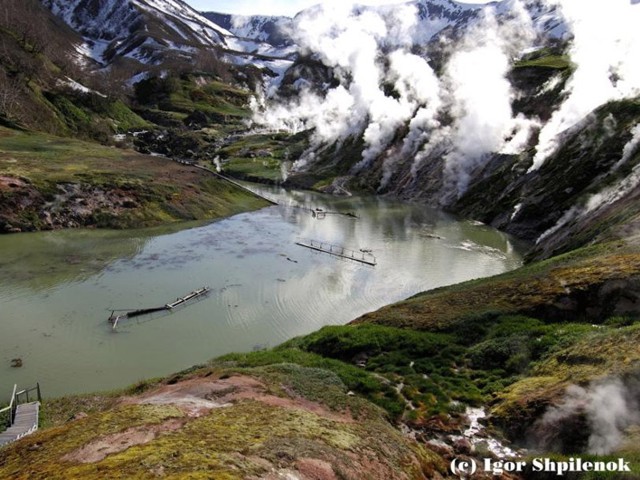 |
Figure 7. At Uzon boiling springs and plumes emerged along the banks of the dammed Geyzernaya river after the new lake's water level dropped. Copyrighted photo by Igor Shpilenok; taken from the Leonovs' report. |
Other information. Igor Shpilenok, a nature photographer, has posted on the web a suite of impressive before-and-after photos. The photos include shots of the upland area that spawned the landslide prior to the event.
On 20 June, Jesse Allen from NASA published an article about the slide discussing a satellite image of the area captured on 11 June. He noted "The Advanced Spaceborne Thermal Emission and Reflection Radiometer (ASTER) on NASA's Terra satellite captured this infrared-enhanced image on [11 June] 2007, a week after the slide. The image shows the valley, the landslide, and the new thermal lake. Even in mid-June, just days from the start of summer, the landscape is generally covered in snow, though the geologically heated valley is relatively snow free. The tree-covered hills are red (the color of vegetation in this false-color treatment), providing a strong contrast to the aquamarine water and the gray-brown slide.
Lundgren and Lu (2006) noted that their satellite interferometry data showed significant deformation spanning 2000 to 2003. During that interval, they noted ~ 0.15 m of inflation occurred at Geyzernaya caldera. As previously mentioned, the data indicated an area of uplift centered roughly at point Ic on figure 1. In contrast, during1999-2000, and 2003-2004 the radar data failed to indicate significant deformation. Lundgren and Lu (2006) point out that the surface-incidence angles (angles from the vertical) are nearly as sensitive to horizontal as to vertical displacements in the range direction (to the WNW). Based on the maps by Leonovs shown above, the upper portion of the landslide was directed roughly the same way (NW).
For the 2000-2003 interval, modeling by Lundgren and Lu (2006) suggested the main regions of uplift occured beneath central and eastern parts of the Uzon-Geyzernaya volcano-tectonic depression, with extension beyond the caldera to the NE beneath Kikhpinych volcano. Uplift was bounded to the ESE by the graben (the linear feature cutting E of the caldera in figure 1).
Figure 8 shows synthetic-aperture radar (SAR) interferograms, where each shading cycle represents 2.8 cm of line-of-sight displacement at the surface. Hatched lines indicate the caldera rim. This interferogram stems from radar images during the date range 19 September 2000-11 August 2003. This is only one of several interferograms Lundgren and Lu (2006) presented for the interval of significant surface displacement.
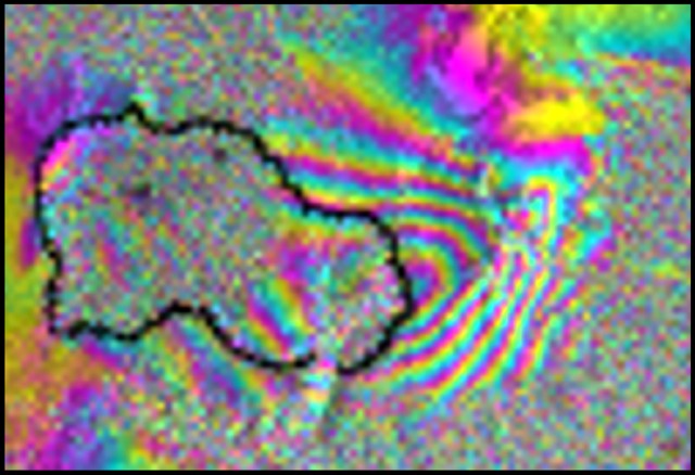 |
Figure 8. A radar interferogram for Uzon and vicinity showing over 10 cm of uplift centered on the caldera's E rim. The image was also associated with a stated perpendicular baseline Bp=58 and RADARSAT-1 beam and surface-incidence angle from vertical for Beam 4 of 38°. From Lundgren and Lu (2006; their figure 2c). |
References. Leonov, V.L., Grib, E.N., Karpov, G.A., Sugrobov, V.M., Sugrobova, N.G, and Zubin, Z.I., 1991, Uzon caldera and Valley of Geysers, in Active Volcanoes of Kamchatka, edited by S.A. Fedotov and Y.P. Masurenkov, Nauka, Moscow, p. 92-141.
Lundgren, P., Lu, Z., 2006, Inflation Model of Uzon Caldera, Kamchatka, Constrained by Satellite Radar Interferometry Observations: Geophys. Res. Ltrs, 16 March 2006 (Vol. 33, No. 6, L06301, Paper No. 10.1029/2005GL025181) (PDF file currently available at http://volcanoes.usgs.gov/insar/public_files/Lundgren_Lu_Uzon_GRL_2006.pdf).
Geological Summary. The Uzon and Geysernaya calderas, containing Kamchatka's largest geothermal area, form a 7 x 18 km depression that originated during multiple mid-Pleistocene eruptions. Widespread ignimbrite deposits associated with caldera formation have a volume of 20-25 km3 (exclusive of airfall deposits) and cover an area of 1,700 km2. Post-caldera activity was largely Pleistocene in age and consisted of the extrusion of small silicic lava domes and flows and maar formation in the Geysernaya caldera. The Lake Dal'ny maar in the NE part of the 9 x 12 km western Uzon caldera is early Holocene in age, and several Holocene phreatic eruptions have been documented in the Geysernaya caldera. The extensive high-temperature hydrothermal system includes the many hot springs, mudpots, and geysers of the Valley of Geysers, a 4-km-long canyon on the SE margin of the depression. Hydrothermal explosions took place in the caldera in 1986 and 1989.
Information Contacts: Vladimir L. Leonov and Ivan F. Delemen, Institute of Volcanology and Seismology, Far Eastern Branch of Russian Academy of Sciences (IVaS FEB RAS), 9 Piip Boulevard, Petropavlovsk-Kamchatsky, Kamchatka 683006, Russia; Andrei V. Leonov (URL: http://www.kscnet.ru/ivs/expeditions/2007/Geyser_Valley-06-2007/Geyser_Valley-06.htm); Igor Shpilenok, Russian Nature Photography, Chukhrai, Suzemsky raion, Bryansk oblast, 242181, Russia (URL: http://www.shpilenok.ru/); Jesse Allen, NASA Earth Observatory (URL: http://earthobservatory.nasa.gov/).