Report on Ruapehu (New Zealand) — October 2007

Bulletin of the Global Volcanism Network, vol. 32, no. 10 (October 2007)
Managing Editor: Richard Wunderman.
Ruapehu (New Zealand) Hydrothermal explosion on 25 September 2007 with plume and lahars
Please cite this report as:
Global Volcanism Program, 2007. Report on Ruapehu (New Zealand) (Wunderman, R., ed.). Bulletin of the Global Volcanism Network, 32:10. Smithsonian Institution. https://doi.org/10.5479/si.GVP.BGVN200710-241100
Ruapehu
New Zealand
39.28°S, 175.57°E; summit elev. 2797 m
All times are local (unless otherwise noted)
There were no reports of activity at Ruapehu following the lahar initiated by the bursting of the tephra dam at Crater Lake on 18 March 2007 (BGVN 32:06). On 25 September an explosive, relatively small, eruption prompted GeoNet to raise the Alert level to 2 (on a scale of 0-5). The eruption, which was probably emitted from Crater Lake, was accompanied by an earthquake (M 2.9) lasting eight minutes. The earthquake, preceded by about 10 minutes of minor seismicity, was too weak and short in duration to provide any meaningful warning of the eruption. Pilots reported a plume that rose to an altitude below 4.6 km.
On 26 September, aerial observations (figure 35) revealed that the summit area was covered with ash and mud, mostly directed N, and deposits reached 2 km from Crater Lake. The ballistic rockfall apron exceeded the ashfall zone, indicating the force of ejection. Impact craters caused by large falling blocks (more than 1 m in diameter) were also evident. The ballistic rocks, ejected from the bottom of the lake, were of several types: andesitic flows from the 1945 and 1995/1996 eruptions, a variety of tephra, and vent-fill debris. To date, there has been no evidence of fresh magma in the ejecta.
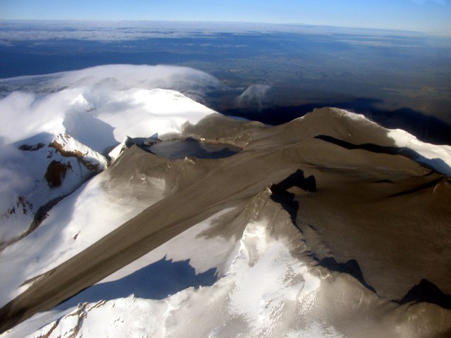 |
Figure 35. Summit of Ruapehu, taken from a plane on 26 September 2007, showing a lahar on the Whangaehu glacier. Courtesy of GeoNet. |
Reports from ski-field operators, the Eastern Ruapehu Lahar Alarm and Warning System (ERLAWS), and scientists from GNS Science and Massey University indicated that at least two eruption-associated lahars occurred. The Whakapapa ski field lahar traveled W approximately 1 km down the ski field, reaching halfway down the far west T-bar to an elevation of about 2,100 m. The deposit is about 30 m wide and consists of gray ashy snow, with fragments of rime ice and scattered rocks. Initial estimates suggest the lahar traveled at 20-30 km/hour.
A snow slurry lahar also traveled E down the Whangaehu River, leaving a deposit about 80 m wide and 1-3 m thick near the Round-the-Mountain-Track Bridge 7 km from Crater Lake. The deposits comprise dirty granular snow with a small percentage of Crater Lake water and mud, and scattered ice fragments and pieces of rock. The deposits thin rapidly downstream, with a thickness of ~ 40 cm at the bund (10 km), 30 cm at the Wahianoa aqueduct (23 km), and 10-20 cm at the Rail gauge (28 km). Data from flow monitoring indicated two depositional and one erosional flow phase.
According to scientists from GNS Science and the Department of Conservation who visited on 27 September, the crater lake was 2-3 m below overflow, indicating that about 500,000 m3 of water was ejected during the eruption. There was a strong upwelling from the northern vent under the lake, and some sulfur slicks and white frothy, gas-rich patches on the lake surface. A much less active discharge was observed over the usually more active southern vent area. The lake was a uniform gray color, being well-mixed. The lake temperature just after the eruption was 19°C, compared to 13°C before the eruption.
There is evidence for hydrothermal sealing of the vent prior to the eruption. A number of sulfur-bearing rocks show evidence of the sulfur having been molten on ejection, indicating vent temperatures at the base of the lake in excess of 119°C.
According to news articles, the eruption prompted evacuations at several ski lodges and caused train service to be temporarily suspended. A boulder crashed through the roof of a hut and injured one person.
On 9 October, the Alert Level at Ruapehu was lowered to 1 because no further eruptions had occurred since the 25 September event.
This eruption was similar to the 1969, 1975 and 1988 eruptions, although it was smaller than the 1969 and 1975 events, and larger than 1988 event. All available evidence to date indicates the eruption was hydrothermal.
Geological Summary. Ruapehu, one of New Zealand's most active volcanoes, is a complex stratovolcano constructed during at least four cone-building episodes dating back to about 200,000 years ago. The dominantly andesitic 110 km3 volcanic massif is elongated in a NNE-SSW direction and surrounded by another 100 km3 ring plain of volcaniclastic debris, including the NW-flank Murimoto debris-avalanche deposit. A series of subplinian eruptions took place between about 22,600 and 10,000 years ago, but pyroclastic flows have been infrequent. The broad summait area and flank contain at least six vents active during the Holocene. Frequent mild-to-moderate explosive eruptions have been recorded from the Te Wai a-Moe (Crater Lake) vent, and tephra characteristics suggest that the crater lake may have formed as recently as 3,000 years ago. Lahars resulting from phreatic eruptions at the summit crater lake are a hazard to a ski area on the upper flanks and lower river valleys.
Information Contacts: New Zealand GeoNet Project (URL: http://www.geonet.org.nz/); New Zealand Department of Conservation, Private Bag, Turangi, New Zealand (URL: http://www.doc.govt.nz/); Institute of Geological & Nuclear Sciences (IGNS), Private Bag 2000, Wairakei, New Zealand (URL: http://www.gns.cri.nz/); Shane J. Cronin, Volcanic Risk Solutions, Institute of Natural Resources, Massey University, Private Bag 11 222, Palmerston North, New Zealand (URL: http://volcanic.massey.ac.nz/); Natural Hazards Research Centre, University of Canterbury, Private Bag 4800, Christchurch 8140 (URL: http://www.nhrc.canterbury.ac.nz/); Agence France-Presse (URL: http://www.afp.com/).