Report on Piton de la Fournaise (France) — December 2007

Bulletin of the Global Volcanism Network, vol. 32, no. 12 (December 2007)
Managing Editor: Richard Wunderman.
Piton de la Fournaise (France) Caldera collapse in April 2007; large E-flank lava flows
Please cite this report as:
Global Volcanism Program, 2007. Report on Piton de la Fournaise (France) (Wunderman, R., ed.). Bulletin of the Global Volcanism Network, 32:12. Smithsonian Institution. https://doi.org/10.5479/si.GVP.BGVN200712-233020
Piton de la Fournaise
France
21.244°S, 55.708°E; summit elev. 2632 m
All times are local (unless otherwise noted)
A caldera collapse occurred at this massive, dynamic shield volcano during early April 2007, displacing the 0.8 x 1.1 km floor of the elliptical Dolomieu caldera downward by ~ 330 m (figure 76). This was both the largest collapse at this volcano since 1760, and one of the few large collapse events seen at this volcano. Worldwide, such events are rarely documented by eyewitness or instrumental observations, with best known examples of collapses including those in 1968 at Fernandina (Simkin and Howard, 1970) and in 2000 at Miyake-jima (Kaneko and others, 2005).
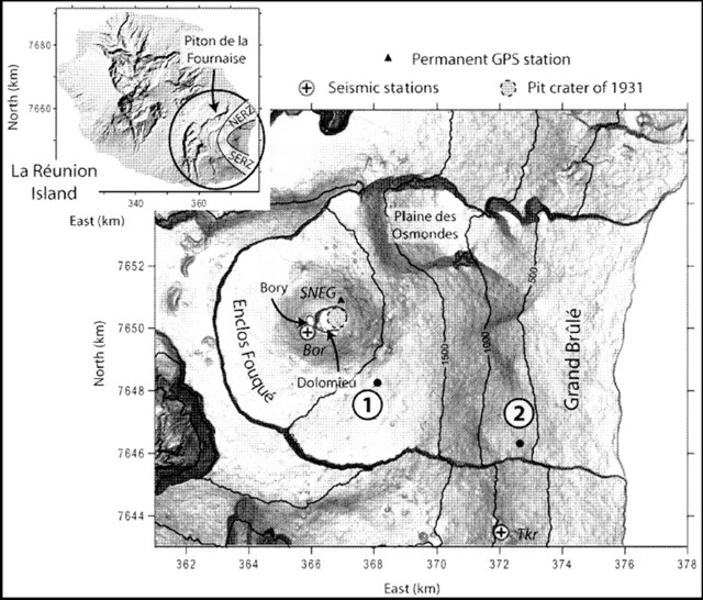 |
Figure 76. Maps taken from Michon and others (2007) showing location and key geography of Piton de la Fournaise volcano on Reunion island. The inset shows the volcano at the island's E end and indicates the volcano's two major NE- and SE-trending rift zones (NERZ and SERZ). The larger map indicates major features, including the Bory and Dolomieu craters (arrows with heads to respective crater rims), two seismic stations, GPS station SNEG, and key vents in the 30-31 March and April eruptive episodes (1, and the main vent, 2). Note the scales on the frame indicate distance in kilometers. |
The collapse at this Piton de la Fournaise occurred in association with the early stages of one of the largest historical discharges of lava flows ever seen here. The resulting lavas traveled E to reach the sea where they built a delta. Concurrent with collapse, the seismicity and deformation were cyclic in nature, suggesting collapse proceeded in a step-by-step manner. These and other events are explained by in a recent paper by Michon and others (2007), the source used to compile this report. Our last report, BGVN32:01, discussed events through 22 February 2007.
Piton de la Fournaise has undergone intense eruptive activity since 1998, with two to four eruptions per year typically venting at the summit and proximal areas. Five distal eruptions occurred during 1998-2007, chiefly concentrated along the NE rift zone, and in particular, on the Plaine des Osmondes. Pahoehoe lava flows had completely filled Dolomieu's floor, accumulating during an August 2006-January 2007 eruption to a thickness of 20-30 m.
Prelude to collapse.On 26 February 2007 seismicity started below the summit zone. It progressively increased and over 100 events took place daily during 28-30 March. Seismicity reached anomalously high levels on 30 March at 2025 local time. About 2.4 hours later, a fissure began erupting at 1,900 m elevation SE of Dolomieu and Bory craters and the central cone (at the point labeled 1, figure 76). Discharges continued for 10 hours. Tremor ceased early the next day.
The 30-31 March eruption included lava fountains up to 50 m in height feeding voluminous lava flows. This event was the debut of a new phase of volcanism that presaged the Dolomieu caldera collapse seen in April.
Collapse.A new eruptive phase began 2 April, venting at ~ 600 m elevation ESE of the central cone (at point 2, figure 76). The venting took place along a NW-trending, 1-km-long fissure.
During the next few days, seismicity rates rose to ~ 3-fold larger than in the previous (26 February) episode. As seismicity grew on 5 April, the permanent GPS instrument SNEG situated just NE of Bory crater's rim (figure 76) started to displace inward. The vertical component of motion began with a jolt around noon and markedly progressed during 1900-2300. Next, at 0048 the next day, an Md 3.2 earthquake occurred below the summit (Bory) crater. After that earthquake, seismic station Takamaka (Tkr, figure 76) registered a signal increase of ~ 50%. Coincident with the earthquake, the GPS instrument displaced ~ 15 cm outward. What followed was a series of cyclic deformation events, episodes composed of displacements progressively inward followed by ones sharply outward.
The displacements linked closely to a series of cyclical seismic and tremor episodes. Each of those consisted of a sharp, post collapse tremor increase, followed by intervals of stable tremor. Many of these initial tremor cycles occurred on roughly two-hour intervals (through the first hours of 6 April), but gradually (with approach to dawn on 6 April) these cycles occurred at about half-hour intervals. On 6 April there occurred a paroxysmal phase during which 200 m high lava fountains vented.
Tremor descended to initial levels before the paroxysmal phase, but cyclical seismic signals remained until 0100 on 7 April. Venting continued until 1 May, accompanied then by fluctuating tremor.
Estimating the volume of lava emitted was complicated by abundant lava having entered the sea at the coast, where it built a large platform, but based on topography and bathymetry before and after the event, the authors' rough estimate, in millions of cubic meters, was ~ 100-140. This makes this one of the most voluminous eruptions at this volcano during the 20th and 21st centuries (figure 77).
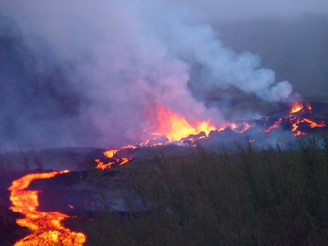 |
Figure 77. Lava flows at Piton del la Fournaise during the eruption of 6 April 2007. Courtesy of OVPF. |
Collapse morphology and structure.The first summit zone observations on the afternoon of the 6th (~ 16 hours after the beginning of the seismic cycles) revealed that the previous geophysical observations and intense eruptions coincided with caldera collapse (figure 78). The 6 April collapse affected the Dolomieu's N part, descending the zone shaded in figure 78b along sub-vertical scarps to the E, N, and W, with a net offset of 200-300 m. The pre-existing floor remained intact on the E and S, forming arc-shaped plateaus there.
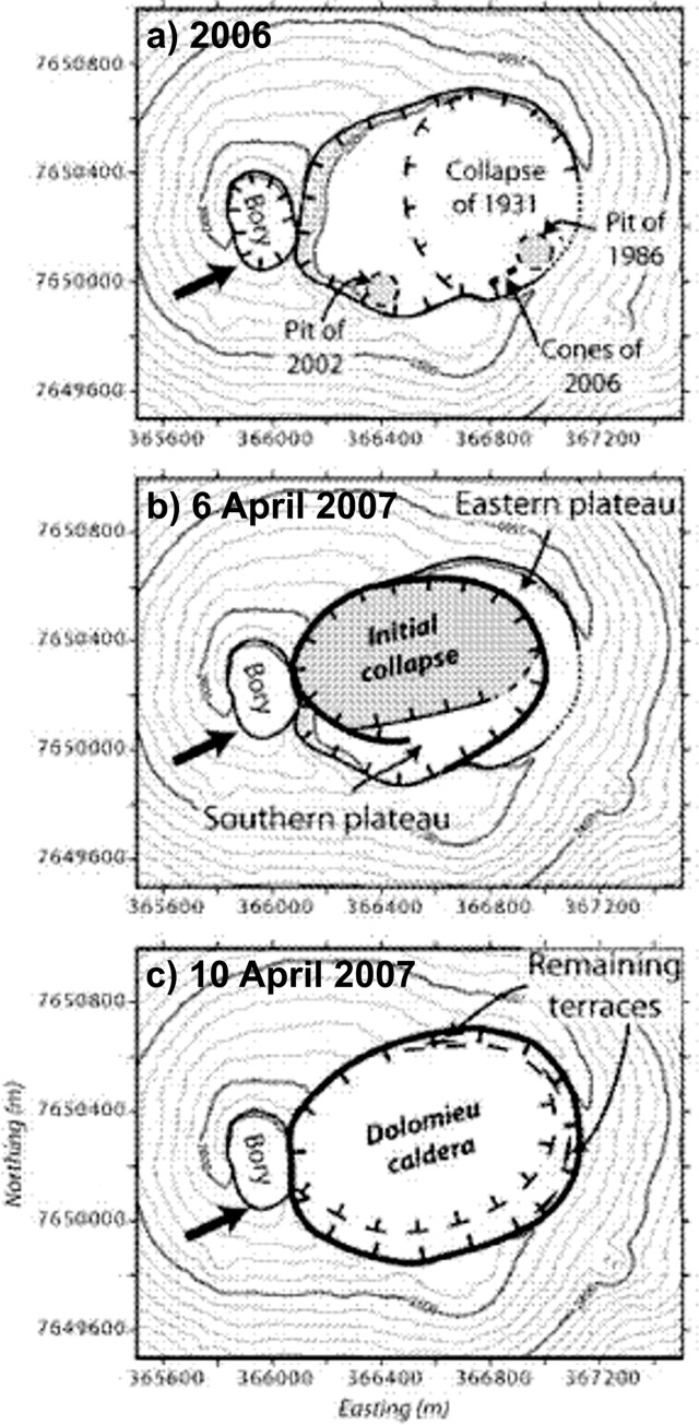 |
Figure 78. Piton de la Fournaise's Dolomieu caldera depicted in sketch maps both prior to the April 2007 eruption and at two stages during the eruption. The first part (a) represents 31 October 2006. The arrow indicates a fracture network (Carter and others, 2007). After Michon and others (2007). |
On 10 April the caldera had enlarged to engulf most of the Dolomieu structure. It had deepened to a maximum offset (determined from triangulation and confirmed with ASTER stereo images) of 320 to 340 m. Perched plateaus were restricted to the indicated zones. Subsequent morphologic changes were minor. The post-collapse caldera had diameters of 800 x 1,100 m and encompassed 82 x 104 m2, an area 11% larger than it was prior to the April eruptions.
The authors estimated that the post-collapse caldera's downward movement displaced a volume of 100-120 million cubic meters. This displacement was comparable to their estimated volume of emitted lava (~ 100-140 million cubic meters). The initial stage of collapse (seen 6 April; figure 78b) accounted for ~ 80% of the total volume displaced in the offset.
The April collapse may have followed pre-existing arcuate faults. It may also have described a magma chamber, the size and location of which were recently determined from a GPS inversion (Peltier and others, 2007). That study suggested a shallow chamber with diameters of 1.4 km and 1.0 km in the respective E-W and N-S directions.
References.Kaneko, T., Yasuda, A., Shimano, T., Nakada, S., and Fujii, T., 2005, Submarine flank eruption preceding caldera subsidence during the 2000 eruption of Miyakejima Volcano, Japan: Bull. Volcanol., v. 67, p. 243-253, doi: 10.1007/s00445-004-0407-1.
Michon, L., Staudacher, T., Ferrazzini, V., Bachélery, P., and Marti, J., 2007, April 2007 collapse of Piton de la Fournaise: A new example of caldera formation: Geophysical Research Letters, v. 34, p. L21301, doi:10.1029/2007GL031248,2007.
Peltier, A., Staudacher, T., and Bachélery, P., 2007, Constraints on magma transfers and structures involved in the 2003 actity at Piton de La Fournaise from displacement data: J. Geophys. Res., v. 112, p. B03207, doi: 10.1029/2006JB004379.
Simkin, T., and Howard, K. A., 1970, Caldera collapse in Galapagos Islands, 1968: Science, v. 169, p. 429-437.
Geological Summary. Piton de la Fournaise is a massive basaltic shield volcano on the French island of Réunion in the western Indian Ocean. Much of its more than 530,000-year history overlapped with eruptions of the deeply dissected Piton des Neiges shield volcano to the NW. Three scarps formed at about 250,000, 65,000, and less than 5,000 years ago by progressive eastward slumping, leaving caldera-sized embayments open to the E and SE. Numerous pyroclastic cones are present on the floor of the scarps and their outer flanks. Most recorded eruptions have originated from the summit and flanks of Dolomieu, a 400-m-high lava shield that has grown within the youngest scarp, which is about 9 km wide and about 13 km from the western wall to the ocean on the E side. More than 150 eruptions, most of which have produced fluid basaltic lava flows, have occurred since the 17th century. Only six eruptions, in 1708, 1774, 1776, 1800, 1977, and 1986, have originated from fissures outside the scarps.
Information Contacts: Laurent Michon and Patrick Bachélery, Laboratoire GéoSciences Réunion, Institut de Physique du Globe de Paris, Université de La Réunion, CNRS, UMR 7154-Géologie des Systèmes Volcaniques, La Réunion, France; Thomas Staudacher and Valérie Ferrazzini, Observatoire Volcanologique du Piton de la Fournaise, Institut de Physique du Globe de Paris, 14 route nationale 3, 27 ème km, 97418 La Plaine des Cafres, La Réunion, France (URL: http://www.ipgp.fr/fr/ovpf/actualites-ovpf/); Joan Marti, Institute of Earth Sciences "Jaume Almera," Consejo Superior de Investigaciones Cientificas, Barcelona, Spain.