Report on Nevado del Huila (Colombia) — January 2008

Bulletin of the Global Volcanism Network, vol. 33, no. 1 (January 2008)
Managing Editor: Richard Wunderman.
Nevado del Huila (Colombia) Eruptions in February, April, and May 2007; lahars take out bridges
Please cite this report as:
Global Volcanism Program, 2008. Report on Nevado del Huila (Colombia) (Wunderman, R., ed.). Bulletin of the Global Volcanism Network, 33:1. Smithsonian Institution. https://doi.org/10.5479/si.GVP.BGVN200801-351050
Nevado del Huila
Colombia
2.93°N, 76.03°W; summit elev. 5364 m
All times are local (unless otherwise noted)
Nevado del Huila was the scene of elevated seismicity during February and May 2000 (BGVN 25:05). In 1994, the M 6.4 Paéz earthquake triggered avalanches and lahars along the Paéz river, which took many lives (BGVN 19:05, 19:07). A more recent abstract summarized the losses from the Paéz earthquake as 271 reported deaths, 1,700 people missing, and more than 32,000 people evacuated during the crisis (Schuster, 1996). Correa and Pulgarín (2002a, b) wrote reviews of the volcano's geology, hazards, and related topics.
This report discusses the onset of eruptions during February 2007 and repeated eruptions during April and May 2007. During the most active intervals during February and April there were substantial ash plumes, lahars, earthquake swarms (and some individual earthquakes up to M ~ 3), and the growth of fissures, crevasses, and new fumaroles on the volcano's upper, glacier-covered slopes. During the April eruption thousands of residents evacuated. This report draws heavily on material issued by the Instituto Colombiano de Geología y Minería (INGEOMINAS), Observatory Vulcanológico and Sismológico de Popayán.
The andesitic-dacitic edifice (figure 6) is large and elongate (with a footprint of ~ 170 km2 ). Located in the Central Cordillera (figure 7), it forms Colombia's highest peak. This area only 3 degrees from the equator experiences periods of high precipitation. In 1995 its alpine glaciers covered ~ 13.4 km2 with an approximate volume of 800 x 106 m3 (Pulgarín and others, 2005).
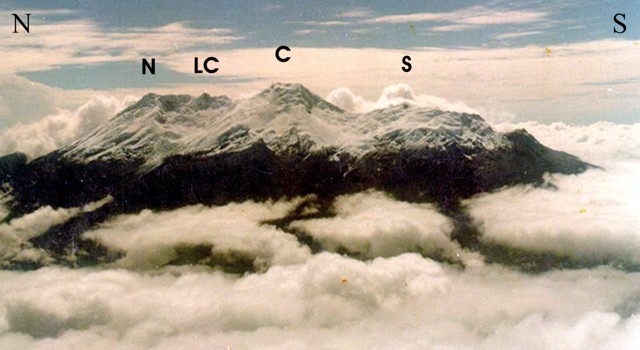 |
Figure 6. An aerial photo showing the upper slopes of Nevado del Huila from the W. The photo was taken at unknown date prior to 2002 when the volcano was in a non-eruptive state. From N to S the four main peaks consist of Pico Norte ("N"), Pico la Cresta ("LC"), Pico Central ("C"), and Pico Sur ("S"). Heavy cloud banks such as those in the foreground are common, adding to the difficulty of monitoring this remote, high stratovolcano. Taken from Correa and Pulgarín (2002a). |
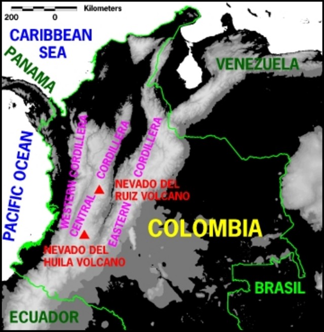 |
Figure 7. A sketch map showing the three distinct ranges (cordillera) of the Andes in Colombia, with Nevado del Huila indicated. Between the Western and Central cordillera, the valley contains the Cauca river (not shown). It flows N and ultimately joins the Magdalena river (not shown), traveling ~ 1,350 km beyond its starting point to reach Northern Colombia. Between the Central and Eastern cordillera, the valley contains the Magdalena river (not shown). It flows N and travels ~ 1,500 km before entering the Caribbean sea at Barranquilla. After a digital elevation map prepared by the USGS; courtesy of the International Charter "Space and Major Disasters." |
The April 2007 activity impacted not only the immediate vicinity of the volcano, but also ten's of kilometers to the S, where rivers carried debris. In order to assess the impact of the lahars, INGEOMINAS compared calibrated Landsat images from before and after the 19 February eruption. They found clear visual evidence that the lahars had discolored the Betania Reservoir, ~ 150 km downstream.
The Símbola joins the Paéz river ~ 28 km (straight-line distance) S of Pico Central (figure 8). Adjacent that intersection sits the town of Belacázar (figure 9). Another ~ 15 km downstream, the Paéz merges into the Magdalena river, the 6th largest river the world in terms of sediment yield (~ 690 t / (km2 ? yr); Restrepo and others, 2005). A straight-line distance of ~ 50 km downslope from the intersection of the Paéz and Magdalena rivers, the Magdalena enters the Betania Reservoir.
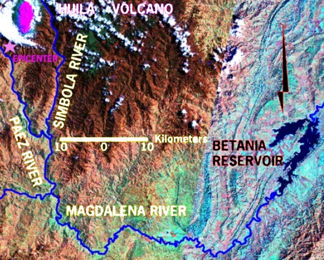 |
Figure 8. A false-color Landsat TM5 mosaic image showing the Magdalena river and some of its headwaters (eg. the Paéz and Símbola rivers) that feed from Nevado del Huila (upper left corner). Images are Landsat-5, 30-m resolution. Left image acquired 7 August 1989. Right image acquired 2 January 1988. The annotations include the epicenter for the Paéz earthquake (star) and the Betania Reservoir. On the colored version, snow is shown by the elongate magenta region around Huila.Created March 2007 by INGEOMINAS; courtesy of the International Charter "Space and Major Disasters." |
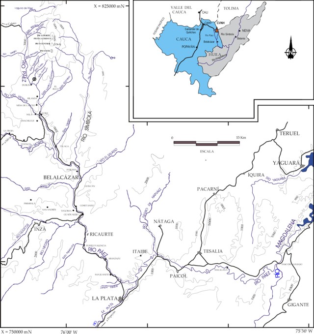 |
Figure 9. Map indicating the topography and naming conventions on the Huila edifice and some surrounding regions. The inset shows the volcano's location at the triangle labeled CVNH. Note epicenter for the Paéz earthquake. This was modified from a larger map in Correa and Pulgarín (2002a). |
Beyond the reservoir, the Magdalena flows NNE; it ultimately reaches the Carribean Sea at a large delta in N Colombia by the large city of Barranquilla (figure 7). According to Restrepo and Kjerfve (2000), "the Magdalena is the largest river discharging directly into the Caribbean sea [228 km3 water annually], and it has the highest sediment yield of any medium-sized or large river along the entire E coast of South America."
Unrest and 19 February eruption. Since 1994 the volcano has been monitored by multiple telemetered seismometers with data sent to the city of Popayán (~ 100 km SSW). Mumucué (2007) pointed out that people living around the volcano saw the appearance of fumaroles in October 2006.
From 22 November 2006, INGEOMINAS assigned an elevated hazard of Level II ('Eruption probable in the coming days or weeks'). Some fracture-related earthquakes took place at depths of 2 km below the summit. Some of these earthquakes reached MR 1.6-1.9.
A 13 February flight mainly found steam escaping both secondary craters and fumarole fields on the main crater's margin. The previous day, observers W of the volcano in Consacá saw steam emissions outside the crater.
A seismometer recorded an earthquake swarm during 1030-1259 on 18 February. The seismometer, located 2 km S of Pico Central (at station 'Cerro Negro') measured 108 earthquakes interpreted as rock fracture events in the upper part of the volcano. An M 3 earthquake followed, and at 0137 on 19 February a new swarm of 53 earthquakes occurred. In this swarm fracture earthquakes were accompanied by those of longer period; the amplitude and number of events increased into the next morning.
Seismic records also contained some long-period earthquakes called tornillos (events with long, gradually decreasing codas or tails, so that their seismic trace resembles the tapering profile of a wood screw; tornillo is Spanish for screw). During March 2006-February 2007, instruments had recorded 105 tornillos (an average of 9 per month). In contrast, during 1-19 February 2007, instruments recorded 20 tornillos, more than double the number usually seen during a full month.
INGEOMINAS reported two earthquakes on 19 February 2007, at 0830 and 0853, with probable explosive character. Aviation authorities reported ash-bearing columns over the edifice reaching ~ 0.6-0.7 km above the summit.
A later INGEOMINAS summary of events stated that the eruption began at 0856 on 19 February, manifested as a ~ 1.5 km tall eruption column blowing mainly W. Ashfall was noted by inhabitants of Toribio, Silvia, and Páez (in the Department of Cauca). Small mudflows came down the Bellavista and Azufrada rivers feeding into the Paéz river, but airborne observers found significant fresh deposits at higher elevations. Authorities advised inhabitants to move to higher ground. Inhabitants noticed the rise of the Paéz river at 1150 on 19 February.
A 20 February flight detected significant fresh ash, abundant crevasses in the ice, and a steaming fissure near the summit (figure 10). The fissure extended ~ 2 km between Pico Central and Pico la Cresta to the N. Observers noted that the fissure continually emitted gases along its entire length. The flight was a collaboration between INGEOMINAS and IGEFA (Inspección General de la Fuerza Aérea).
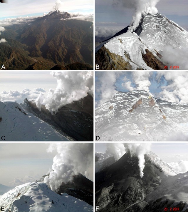 |
Figure 10. (a-f) Six aerial photos of Nevado del Huila taken from multiple angles and distances on 20 February 2007. A) A view with the Paéz river basin in the foreground and with Nevado del Huila steaming in the background. B) A close up of the SE flank looking NW, showing dark snow on the W side of the volcano and a thinner coating on the E side. C) Contrasting ash-free and thickly ash-covered ice at the N-central side of the summit (Pico Central to the right), with the elongate fissure emitting steam near the ridgeline. D) Pico Central seen at comparatively close range from the E side of the mountain, where a thin coating of ash is apparent over many of the upper slopes. E) A view looking S across Pico la Cresta slightly off the trend of the ridge axis, highlighting steam emissions from the fissure, areas of ash-covered snow, and abundant fresh crevasses in the upslope ice. F) A photo looking NW at the gray ash deposits on glacial ice of Pico Central and again illustrating venting steam. Courtesy of the Colombian Air Force and INGEOMINAS. |
A VAAC report noted an eruption at about 1400 UTC on the 19th to approximately FL 200 (~ 6.1 km altitude) moving W and dissipating quickly. No ash was seen in satellite imagery the next day at either 0045 or 1100 UTC, however, around this latter time, a pilot observed an ash cloud. In addition, a local aircraft reported ash to ~ 6.1 km at 0500 UTC on the 21st.
During 30 March-16 April 2007 INGEOMINAS observers reported the initiation of noteworthy seismicity indicating rock fractures and movement of fluids. The fracture events were located at depths of 4-8 km E and SW from the central peak and at magnitudes of less than 1.0. Low gas columns were again seen on 11 April, moving W.
Seismicity further increased on 17 April, leading up to an eruption on the 18th. Early on 18 April, a cluster of 25 rock-fracture earthquakes occurred, M 0.5 to 1.5. These were located at a depth less than 2 km. Seismicity again increased later that morning.
April 2007 eruption. A brief summary of the 18 April eruption appeared on the website hosted by the International Charter "Space and Major Disasters" on 20 April). It stated, "The Nevado del Huila volcano erupted at 02:57 local time 18 April, causing avalanches and floods [lahars] which affected the villages of La Plata, Paicol, Tesalia, Natagá, [and] Belalcázar. About 5,000 people were evacuated." (That same website hosted more than 10 (Landsat, Radarsat, and Envisat) images shedding light on this remote volcano's behavior, hazards, and impacts).
According to an 18 April 2007 report from the Washington Volcanic Ash Advisory Center (VAAC), a pilot in Colombia saw an ash cloud. Two ash plumes were evident on GOES-10 (split window) satellite imagery for an eruption starting at 0815 UTC on 18 April. They rose to poorly constrained altitudes of ~ 9 and 11 km and drifted E at 9 km/hour. The lower ash cloud was ~ 37 km across and moved SW at 9-18 km/hour. The higher ash cloud was ~ 19 km across and moved E at 0-9 km/hour. These clouds had dissipated by 1034 UTC.
The 18 April eruption sent an a torrent of brown water and rocks down the volcano's sides and into the Paéz and Símbola rivers (figures 11 and 12), causing them to flood, destroying several kilometers of highway and endangering or sweeping away what some government reports stated were 15 bridges (although it is uncertain how many of those were footbridges, and new reports tended to indicate a slightly higher numbers). In an evaluation the lahars of 18 April, INGEOMINAS staff found them quite similar, though smaller, than those of the earthquake and disaster of 1994.
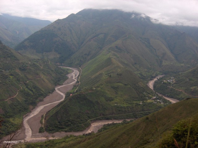 |
Figure 11. Photo from hillside overlooking the confluence of the Paéz and Símbola rivers, viewed upstream towards Nevado del Huila. One of the battered and partly lahar-covered bridges lies in the left-foreground. Photo was taken 25 April 2007 and came from Mumucué (2007). |
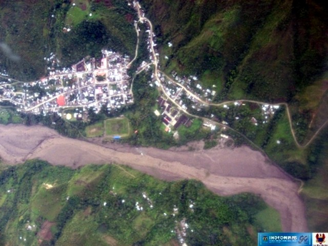 |
Figure 12. An aerial photo of part of the Huila lahar shot in sub-vertical orientation on 22 April 2007. Name and location of this settlement is uncertain. Lahars were apparently insufficiently thick to overrun established settlements. Courtesy of INGEOMINAS. |
Videos. At least three videos taken chiefly from Colombian military or national guard helicopters were posted on the web during April-May 2007 (see Videos, under References). They featured either the volcano or the powerful lahars or both, as follows.
Video 1("Avalancha . . ."; posted 18 April 2007) contains lahar footage from a television newscast, much of it taken from a helicopter. The shots include several bridges destroyed or impacted by lahars and the dialog mentioned nineteen bridges affected. Segments also show closeups of sediments and considerable flooding. Few if any flooded or damaged buildings were shown. Footage shows segments of the river with various gradients; the dark water carrying considerable debris. In one scene of a threatened bridge taken from shore, the turbulent river races by and among the passing logs seemingly floats a large farm animal.
Video 2 ("Sobrevuelo . . ." [Overflight . . .]) was taken by INGEOMINAS on 3 March 2007. It shows the volcano in modest eruption. A dense, dark plume emerges from the complex ice-bound summit area. Somewhat surprisingly, the plume immediately descends one flank of the volcano.
Video 3 (Erupcion . . . 18 Abril) shows vigorous white plumes escaping from multiple vents and forming a dense white plume. The text says that the footage was taken hours after the eruption on 18 April 2007. The base of the volcano is shrouded in weather clouds. The footage credits "Ejercito Nacional-INGEOMINAS-FAC."
Further observations and assessments. Seismicity escalated during 19-20 April but decreased on the 21st. Two larger earthquakes soon took place, on the 22nd and 27th. Their respective seismic signals appeared to come from rock fracturing at shallow depths; they had epicenters at Pico Central, and they were M 3.0 and M 3.2. On 23 April instruments detected continuous low-frequency tremor, interpreted as continuing instability and possible eruptions.
On 22 April, the Colombian Air Force flew INGEOMINAS staff past the volcano. They observed the N-trending fissure seen in February and found it had extended to reach a length of 2.3 km and a width of ~ 200 m. It emitted a white, sulfurous smelling gas column to 5 km altitude. The 22 April observers also saw a second new fissure ~ 2 km long across the same region. Strong fumaroles also discharged. Some lahars remained active down both E and W flank drainages.
Associated with the eruptions and as recent as 28 April 2007, there had been a total of 5,708 seismic events. Of those, 2,861 had signals suggesting rock fracture and 2,847 had signals suggesting movement of fluids.
During late April and early May 2007 the seismicity generally decreased (except for a 6 May, M 3.2 earthquake). On 5 May, INGEOMINAS staff, using a land-based correlation spectrometer, measured an SO2 flux from the volcano at 3,000 tons per day.
Early on 14 May, INGEOMINAS recorded a cluster of 54 low magnitude earthquake events, possibly triggering or associated with an ash emission. Based on satellite imagery of 14 May, the Washington VAAC reported an ash plume 8 km wide in an area 45 km W; it drifted SW and dissipated.
Based on seismic interpretation, INGEOMINAS inferred ash emissions during 27 May. Aerial observations later that day confirmed the emissions. Tremor recorded on 28 May possibly indicated another pulse of ash emissions. The SO2 flux measured on 1 June continued at 3,000 metric tons per day and on 2 June increased to ~ 6,900 metric tons per day. Flights on 3, 6, and 10 June indicated no changes in the existing fissures nor changes in the fumarolic field. Seismicity was relatively quiet during June 2007.
Humanitarian concerns. Luz Amanda Pulido, director of the national disaster office said that there were no reports of deaths or injuries. According to a 22 May report of the UN Office for the Coordination of Human Affairs (OHCA), by 26 April authorities resolved to evacuate 2,307 families affected by the crisis.
A government document issued May 2007 discussed the displaced residents. According to that report (Mumucué, 2007) the number of indigenous inhabitants living around the volcano and affected by lahars or emissions or both totaled 26,949 people. The affected territory he discussed (the Municipio de Páez, which has Belacazar as the main urban center) had an area of ~ 161,000 hectares. The inhabitants losses included cultivated areas and farm animals, including horses and smaller livestock. Photos showed displaced families living in temporary camps with outdoor cooking facilities. Another photo showed workers installing a footbridge where a vehicle bridge was lost to the torrent. That photo, taken ~5 days after the 18 April lahars began showed that by this time the river had greatly receded. The report was also a plea for supplies, including children's clothing and two-way radios with solar panels. Total days of community work devoted to reconstruction after the disaster and as late as May 2007 amounted to 4,264 (Mumucué, 2007).
References. Correa, A.M., and Pulgarín, B.A, 2002a, Revisión histórica de los estudios geológicos y otros aspectos, sobre el volcán Nevado del Huila y su área de influenza, Instituto Colombiano de Geologia y Mineria, INGEOMINAS; Observatorio Vulcanológico y Sismológico, Popayán; Junio de 2002, 51 p.
Correa, A., and Pulgarín, B., 2002b, Morfología, estratigrafía y petrografía general del Complejo Volcánico Nevado del Huila (énfasis en el flanco occidental): INGEOMINAS, Centro Operativo, Popayán, Informe Interno, 104 p.
Mumucué, J.A., May 2007, Analisis de los diversos eventos de erupción volcánica en la región de Tierradentro Páez Cauca hasta el momento: Republica de Colombia, Departamento del Cauca - Region de Tierradentro, Asociación de Cabildos Nasa ?xh??xha.
Pulagarín, B.A., Jordan, E., and Linder, W., 2005, Aspectos geológicos y cambio glaciar del volcán Nevado del Huila entre 1961 y 1995: Proceedings I Conferencia Cambio Climático, Bogotá 2005, 17 p.
Restrepoa, J.D., Kjerfveb, B., Hermelina, M., and Restrepoa, J.C., 2005, Factors controlling sediment yield in a major South American drainage basin: the Magdalena River, Colombia: Journal of Hydrology, v. 316, nos. 1-4, 10 January 2006, p. 213-232.
Restrepoa, J.D., and Kjerfve, B., 2000, Magdalena river: interannual variability (1975-1995) and revised water discharge and sediment load estimates: Journal of Hydrology, v. 235, nos. 1-2, 22 August 2000, p. 137-149, Elsevier.
Schuster, R. L., 1996, Recent earthquake-induced catastrophic landslides in the Andes of Ecuador and Colombia; Abstract, Colorado Scientific Society (URL: http://www.coloscisoc.org/abstracts).
Video References. (1) "Avalancha del Volcan Nevado del Huila" [A newscast from a Colombian television station, www.youtube.com/watch?v=k6nW1DP5mqg
(2) INGEOMINAS, 3 March 2007, Sobrevuelo Ingeominas Nevado Huila pocos dias despues de la erupción" (posted 8 May 2007) [Overflight of summit area] http://www.youtube.com/watch?v=UPP0vzBzZ38 (00:39)
(3) INGEOMINAS, 2007, Erupcion Nevado del Huila Colombia 18 Abril; Video stamped with "Ejercito Nacional-INGEOMINAS-FAC"; http://www.youtube.com/watch?v=xUnYOALOCWg; (00:56) (Posted 8 May 2007)
Geological Summary. Nevado del Huila, the highest peak in the Colombian Andes, is an elongated N-S-trending volcanic chain mantled by a glacier icecap. The andesitic-dacitic volcano was constructed within a 10-km-wide caldera. Volcanism at Nevado del Huila has produced six volcanic cones whose ages in general migrated from south to north. The high point of the complex is Pico Central. Two glacier-free lava domes lie at the southern end of the volcanic complex. The first historical activity was an explosive eruption in the mid-16th century. Long-term, persistent steam columns had risen from Pico Central prior to the next eruption in 2007, when explosive activity was accompanied by damaging mudflows.
Information Contacts: Instituto Colombiano de Geología y Minería (INGEOMINAS), Observatorio Vulcanológico y Sismológico de Popayán, Popayán, Colombia; Washington Volcanic Ash Advisory Center (VAAC), Satellite Analysis Branch (SAB), NOAA/NESDIS E/SP23, NOAA Science Center Room 401, 5200 Auth road, Camp Springs, MD 20746, USA (URL: http://www.ospo.noaa.gov/Products/atmosphere/vaac/); Jorge Castilla Echenique, Salud para desplazados, Programa de Emergencias y Desastres OPS/OMS, PWR Colombia; Jorge E. Victoria R., Salud en Desastres y Emergencias Complejas, Organización Panamericana De La Salud, Oficina de Neiva, Carrera 10 No. 4-72, Huila, Colombia; International Charter-Space and Major Disasters (URL: http://www.disasterscharter.org/).