Report on Suwanosejima (Japan) — February 2008
Bulletin of the Global Volcanism Network, vol. 33, no. 2 (February 2008)
Managing Editor: Richard Wunderman.
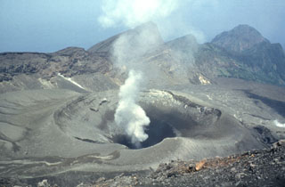
Suwanosejima (Japan) Small (~1 km) plumes noted during late 2007-early 2008
Please cite this report as:
Global Volcanism Program, 2008. Report on Suwanosejima (Japan) (Wunderman, R., ed.). Bulletin of the Global Volcanism Network, 33:2. Smithsonian Institution. https://doi.org/10.5479/si.GVP.BGVN200802-282030
Suwanosejima
Japan
29.638°N, 129.714°E; summit elev. 796 m
All times are local (unless otherwise noted)
Our last Bulletin (BGVN 3211) covered eruptive activity during July 2005 to December 2007. This issue covers eruptions recorded by the Tokyo Volcanic Ash Advisory Center (VAAC) from December 2007 to March 2008. Kinoshita and others (2003) noted that Sakura-jima "has been the most eruptive in Japan, with the eruption columns a few kilometers above the crater occasionally."
Table 5 summarizes information gathered by the Tokyo VAAC from observers between 9 December 2007 and 21 March 2008. In all cases the VAAC could not detect plumes using satellite data. An overview of satellite and image monitoring of Suwanose-jima appears in an article by Kinoshita and others (2003).
Table 5. A summary of Tokyo VAAC reports on ash plumes from Suwanose-jima during 9 December 2007 to 21 March 2008. Cases with only dashes in the data fields were when observers detected an explosion but they were unable to say more about a resulting plume. In many of the examples given, there were multiple Volcanic Ash Advisories issued, but no new data came to light. Courtesy of the Tokyo VAAC.
| Date | Time (UTC) | Plume Altitude (km) | Drift Direction |
| 09 Dec 2007 | 2340 | 1.5 | W |
| 10 Dec 2007 | 0734 | 1.8 | W |
| 14 Dec 2007 | 0914 | -- | -- |
| 15 Dec 2007 | 0016 | 1.8 | E |
| 16 Dec 2007 | 0353 | 1.5 | E |
| 16 Dec 2007 | 2310 | 1.5 | E |
| 08 Feb 2008 | 0248 | 1.8 | E |
| 13 Feb 2008 | 0208 | -- | -- |
| 21 Mar 2008 | 1622 | -- | -- |
Reference. Kinoshita, K., Kanagaki, C., Minaka, A., Tsuchida, S., Matsui, T., Tupper, A., Yakiwara, H., and Iino, N., 2003, Ground and Satellite Monitoring of Volcanic Aerosols in Visible and Infrared Bands: The CEReS International Symposium on Remote Sensing - Monitoring of Environmental Change in Asia, Chiba, Japan, 16-17 December 2003, 10 p.
Geological Summary. The 8-km-long island of Suwanosejima in the northern Ryukyu Islands consists of an andesitic stratovolcano with two active summit craters. The summit is truncated by a large breached crater extending to the sea on the E flank that was formed by edifice collapse. One of Japan's most frequently active volcanoes, it was in a state of intermittent Strombolian activity from Otake, the NE summit crater, between 1949 and 1996, after which periods of inactivity lengthened. The largest recorded eruption took place in 1813-14, when thick scoria deposits covered residential areas, and the SW crater produced two lava flows that reached the western coast. At the end of the eruption the summit of Otake collapsed, forming a large debris avalanche and creating an open collapse scarp extending to the eastern coast. The island remained uninhabited for about 70 years after the 1813-1814 eruption. Lava flows reached the eastern coast of the island in 1884. Only about 50 people live on the island.
Information Contacts: Tokyo Volcanic Ash Advisory Center (VAAC), Tokyo, Japan (URL: https://ds.data.jma.go.jp/svd/vaac/data/).