Report on Cleveland (United States) — February 2008
Bulletin of the Global Volcanism Network, vol. 33, no. 2 (February 2008)
Managing Editor: Richard Wunderman.
Cleveland (United States) Thermal anomalies and minor explosions continue through February 2008
Please cite this report as:
Global Volcanism Program, 2008. Report on Cleveland (United States) (Wunderman, R., ed.). Bulletin of the Global Volcanism Network, 33:2. Smithsonian Institution. https://doi.org/10.5479/si.GVP.BGVN200802-311240
Cleveland
United States
52.825°N, 169.944°W; summit elev. 1730 m
All times are local (unless otherwise noted)
Our previous reports on Cleveland discussed short duration explosions on 6 February 2006 (BGVN 31:01), 23 May 2006 (BGVN 31:07), and on 24 August and 28 October 2006 (BGVN 31:09).
We received no further reports on Cleveland until June 2007. On 12 June, steam emissions were observed. The plume rose to an altitude of 3.7 km and drifted SE for 200 km. On 17 June, satellite imagery showed a significant thermal anomaly. Low level eruptive activity was suggested. No ash plume was detected. On 26 June, satellite imagery showed another thermal anomaly. On 20 July, the Alaska Volcano Observatory (AVO) raised the Alert Level from Advisory to Watch and the Aviation Color Code from Yellow to Orange, based upon an intense thermal anomaly in the crater and an associated steam-and-gas plume observed on satellite imagery. Three small SO2 clouds produced by small explosions on 20 July were detected in OMI satellite data. Weak thermal activity was observed by satellite imagery throughout the month.
On 27 July AVO noted that low-level eruptive activity continued. Photographs from 27 July and a pilot report from 2 August indicated fresh volcanic ejecta on the slopes and summit. The E portion of Chuginadak Island was dusted with ash on 3 August. AVO lacks a local seismic system at the volcano was thus unable to track local volcanic earthquakes.
Thermal anomalies continued to be detected on satellite imagery, although clouds obscured satellite and web camera views of the volcano on most days during August through 11 September. A few clear views of the crater during this time revealed multiple thermal anomalies at the summit, indicating that low-level eruptive activity continued.
On 6 September, AVO lowered the Volcanic Alert Level for Cleveland from Watch to Advisory and the Aviation Color Code from Orange to Yellow, based on the observation that since late July, ash and gas plumes had been absent in satellite imagery and no reports of activity had been received. On 20 November the last weak thermal anomaly was observed for the year.
At 1200 on 17 January 2008, minor ash emission was detected, which drifted N. The plume height could not be determined. Thermal anomalies were found in the satellite imagery later that day. According to the AVO, on 8 February, during a break in the cloud cover, satellite imagery detected a diffuse ash plume extending about 12 km SE at an altitude below 1.5 km. Later that day AVO received pilot reports of a diffuse ash plume that rose to an altitude of 6.1 km and, according to satellite imagery, drifted NW. Due to the increased activity, the Volcanic Alert Level was raised to Watch and the Aviation Color Code was raised to Orange. During 10-11 February, a feeble thermal anomaly was marginally visible on satellite imagery.
On 12 February, the Volcanic Alert Level was lowered back to Advisory and the Aviation Color Code was lowered to Yellow. This occurred in response to the observation that minor eruptive activity appeared to have subsided and no further evidence of ash emission had been reported.
On 15 February, a minor explosion from Cleveland produced a small, diffuse ash plume that rose to an altitude of below 3 km and drifted NW. On 16 February, a brief explosion occurred. On 22 February, satellite imagery detected a low-level ash plume that drifted about 300 km SE. On 23 February, satellite imagery revealed a thermal anomaly. On 29 February, satellite imagery detected a weak thermal anomaly and a small ash plume that rose to an altitude of below 3 km. On 15, 27, and 30 March, weak thermal anomalies were detected. As of 4 April 2008, Cleveland remains at Advisory and the Aviation code Yellow.
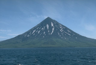
Geological Summary. The beautifully symmetrical Mount Cleveland stratovolcano is situated at the western end of the uninhabited Chuginadak Island. It lies SE across Carlisle Pass strait from Carlisle volcano and NE across Chuginadak Pass strait from Herbert volcano. Joined to the rest of Chuginadak Island by a low isthmus, Cleveland is the highest of the Islands of the Four Mountains group and is one of the most active of the Aleutian Islands. The native name, Chuginadak, refers to the Aleut goddess of fire, who was thought to reside on the volcano. Numerous large lava flows descend the steep-sided flanks. It is possible that some 18th-to-19th century eruptions attributed to Carlisle should be ascribed to Cleveland (Miller et al., 1998). In 1944 it produced the only known fatality from an Aleutian eruption. Recent eruptions have been characterized by short-lived explosive ash emissions, at times accompanied by lava fountaining and lava flows down the flanks.
Information Contacts: Alaska Volcano Observatory (AVO), a cooperative program of the U.S. Geological Survey, 4200 University Drive, Anchorage, AK 99508-4667, USA, the Geophysical Institute, University of Alaska, PO Box 757320, Fairbanks, AK 99775-7320, USA, and the Alaska Division of Geological & Geophysical Surveys, 794 University Ave., Suite 200, Fairbanks, AK 99709, USA (URL: http://www.avo.alaska.edu/); Volcanic Emissions Group, Ozone Monitoring Instrument (OMI)-Total Ozone Monitoring Spectrometer (TOMS), Joint Center for Earth Systems Technology, University of Maryland Baltimore County (UMBC), and NASA Goddard Space Flight Center (URL: http://toms.unbc.edu/).

