Report on Monowai (New Zealand) — March 2008
Bulletin of the Global Volcanism Network, vol. 33, no. 3 (March 2008)
Managing Editor: Richard Wunderman.
Monowai (New Zealand) Eruption recorded on 8 February 2008
Please cite this report as:
Global Volcanism Program, 2008. Report on Monowai (New Zealand) (Wunderman, R., ed.). Bulletin of the Global Volcanism Network, 33:3. Smithsonian Institution. https://doi.org/10.5479/si.GVP.BGVN200803-242050
Monowai
New Zealand
25.887°S, 177.188°W; summit elev. -132 m
All times are local (unless otherwise noted)
On 28 March 2008, reporter Michael Field noted that an eruption of the submarine volcano Monowai was taking place. Olivier Hyvernaud was quoted in the article as saying that they recorded on the Polynesian Seismic Network (Réseau Sismique Polynésien, or RSP) a "big acoustic event" on 8 February. [He also noted that the volcano was in an eruptive phase, but it was not clear if it was a strong eruption.] The news article went on to say that, according to geologist Cornel de Ronde, the French Polynesian RSP currently receives submarine hydrophone signals from Monowai eruptions more easily than stations in New Zealand. The article concluded that this activity went unnoticed as its location is off the main shipping routes.
Ian Wright of the New Zealand National Institute of Water and Atmospheric Research (NIWA) informed us about new volcano discoveries along the S-central Kermadec arc and some recent mapping results from Monowai. In recent years, New Zealand scientists have mapped, using soundings made by multibeam acoustic arrays, most of the Kermadec arc, with the consequent discovery and naming of a number of 'new' arc volcanoes. Some of the more recent work for the 30°-35°S latitude sector was published in Wright and others (2006). A second manuscript detailing the 25°-30°S latitude sector will be completed soon for publication by Graham and others.
Wright and his colleagues mapped Monowai using the multibeam system in 1998 and again in 2004, identifying drastic changes in morphology during that 6-year period. They found edifice collapse and cone regrowth. They interpreted these changes in morphology in the context of T-wave data recorded by Hyvernaud and his colleague Dominique Reymond [Wright and others, 2008 (in press); BGVN 32:01].
As indicated on figures 20 and 21, the group subsequently re-mapped Monowai in mid-2007 for a third time, again finding drastic changes coinciding with a period of ongoing and high T-wave activity. They are currently preparing a manuscript detailing these latter changes (Chadwick and others, in preparation). According to Bill Chadwick, while the research ship was on site conducting the 2007 survey and attempting some remotely operated vehicle (ROV) dives, scientists heard booming sounds and saw slicks and bubbles on the surface.
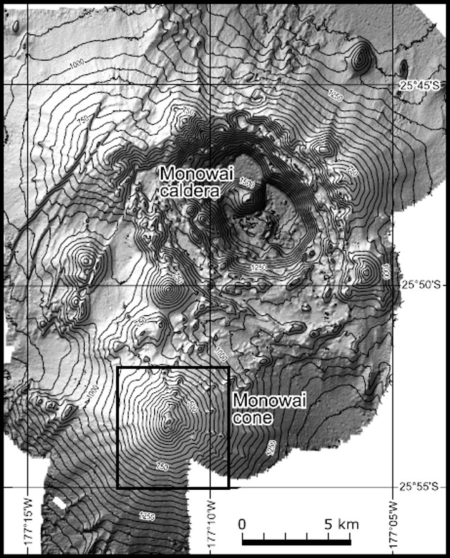 |
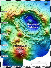
Figure 20. Multibeam bathymetry and shaded terrain model of the Monowai volcanic complex, including its caldera and cone. Isobaths are shown at 50 m intervals. Courtesy of Wright and others, 2008 (in press). |
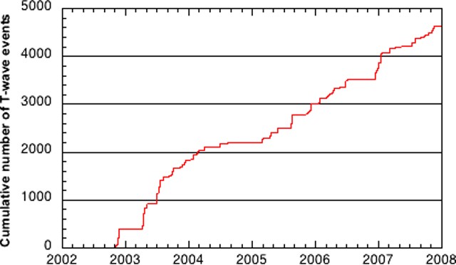 |
Figure 21. Cumulative number of T-wave events centered at Monowai during the latter half of 2002 through 2007 from monitoring data at RSP (covering the times of the September 2004 and May 2007 bathymetric surveys, and the anomalous 24 May 2002 swarm, as reported in BGVN 27:05 and 32:01). Courtesy of Hyvernaud and Reymond, Laboratoire de Geophysique (LDG); from Chadwick and others (in preparation). |
Bob Dziak of NOAA informed the Bulletin staff that Monowai T-phases are recorded on the NOAA East Pacific Rise hydrophone arrays, but analysis of data from those arrays await their retrieval of recording packages from ocean deployment sites. (In contrast, Hyvernaud of LDG in French Polynesia recovers data in real-time.) Dziak also mentioned that, from time to time, T-phase events from what is likely volcanic activity in the Izu-Bonin Mariana region are recorded by the NOAA real-time system in the North Pacific. He offered to provide a later Bulletin report.
A recent paper by de Rhonde and others (2008) noted that all the major submarine volcanic centers on the Kermadec intraoceanic arc NE of New Zealand (including Monowai) are hydrothermally active. The Monowai volcanic complex has two separate and extensive hydrothermal fields associated with the Monowai caldera and the Monowai cone, respectively.
References. Wright, I.C., Worthington, T.J., and Gamble, J.A., 2006, New multibeam mapping and geochemistry of the 30°-35°S sector, and overview, of southern Kermadec arc volcanism, Journal of Volcanology and Geothermal Research, v. 149, p. 263-296.
Wright, I. C., Chadwick, W., de Ronde, C. E. J., Reymond, D., Hyvernaud, O., Gennerich, H., Stoffers, P., Mackay, K., Dunkin, M., and Bannister, S., 2008 (in press), Collapse and reconstruction of Monowai submarine volcano, Kermadec arc, 1998-2004, Journal of Geophysical Research, doi:10.1029/2007JB005138.
de Ronde, C.E.J., Baker, E.T., Lupton, J.L., Sprovieri, M., Bruno, P.P., Faure, K., Leybourne, M.I., Walker, S.L., Italiano, F., Embley, R.W., Graham, I., Greene, R.R., Wright, I.C., and NZAPLUME III & Aeolian'07 shipboard parties, 2008, Contrasting examples of submarine hydrothermal venting along the Kermadec intraoceanic arc and the Aeolian island arc, Geophysical Research Abstracts, v. 10, EGU2008-A-05597, 2008 (SRef-ID: 1607-7962/gra/EGU2008-A-05597).
Geological Summary. Monowai, also known as Orion seamount, is a basaltic stratovolcano that rises from a depth of about 1,500 to within 100 m of the ocean surface about halfway between the Kermadec and Tonga island groups, at the southern end of the Tonga Ridge. Small cones occur on the N and W flanks, and an 8.5 x 11 km submarine caldera with a depth of more than 1,500 m lies to the NNE. Numerous eruptions have been identified using submarine acoustic signals since it was first recognized as a volcano in 1977. A shoal that had been reported in 1944 may have been a pumice raft or water disturbance due to degassing. Surface observations have included water discoloration, vigorous gas bubbling, and areas of upwelling water, sometimes accompanied by rumbling noises. It was named for one of the New Zealand Navy bathymetric survey ships that documented its morphology.
Information Contacts: Ian Wright, New Zealand National Institute of Water and Atmospheric Research (NIWA), Private Bag 14-901, Wellington, 6003, New Zealand; Cornel de Ronde, GNS Science, Lower Hutt, 5040 New Zealand; Olivier Hyvernaud and Dominique Reymond, Laboratoire de Géophysique, Commissariat a l'Energie Atomique (CEA/DASE/LDG), PO Box 640, Papeete, Tahiti, French Polynesia; GNS Science, Wairakei Research Center, Private Bag 2000, Taupo 3352, New Zealand (URL: http://www.gns.cri.nz/); Michael Field, Fairfax Media, Auckland, New Zealand; William Chadwick and Robert Dziak, NOAA and Cooperative Institute for Marine Resources Studies at Oregon State University, 2115 SE OSU Drive, Newport, OR 97365.