Report on Karkar (Papua New Guinea) — March 2008

Bulletin of the Global Volcanism Network, vol. 33, no. 3 (March 2008)
Managing Editor: Richard Wunderman.
Karkar (Papua New Guinea) Seismic monitoring of increased fumarolic activity
Please cite this report as:
Global Volcanism Program, 2008. Report on Karkar (Papua New Guinea) (Wunderman, R., ed.). Bulletin of the Global Volcanism Network, 33:3. Smithsonian Institution. https://doi.org/10.5479/si.GVP.BGVN200803-251030
Karkar
Papua New Guinea
4.647°S, 145.976°E; summit elev. 1839 m
All times are local (unless otherwise noted)
During late 2007 and continuing into 2008, it became clear the Karkar's vegetation had suffered and seismicity was significant (tens of earthquakes per day). Herman Patia of the Rabaul Volcano Observatory (RVO) reported that the Bagiai cone situated in the inner caldera of Karkar volcano continued to release thin to moderate white vapor while a RVO team was at the volcano from 27-31 December 2007. The white vapor plume was also visible from the mainland. Prior to the visit, communities on the W and SW had heard occasional roaring noises associated with the gas emission from the Bagiai cone. The last Bulletin (BGVN 25:11) discussed light ashfall ultimately attributed to Ulawun. In early November 2007, RVO had reported vegetation die-back and increased fumarolic activity at Bagiai cone on the floor of the inner caldera (figure 5). Latest images sent to RVO by Sir Peter Barter on 11 December 2007 indicated that vegetation on the SE flank had withered completely. According to RVO, the last eruption of Karkar was in 1979.
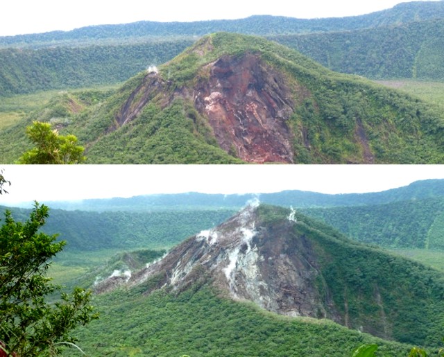 |
Figure 5. Vegetation die-back and increased fumarolic activity on Bagiai cone at Karkar; (top) photo taken early in 2007, (bottom) photo taken during the last week of October 2007. Courtesy of RVO; photos by Paul Goodyear. |
During the team's December visit, they deployed three portable seismic recorders on the NW, SW, and E sides of the island (figure 6, open triangles). Preliminary results indicated a total of 30 high-frequency (HF) earthquakes recorded during the 3 days of deployment. These events were interpreted as indicative of rock-breaking due to magma movement under the volcano. The overall seismicity was low.
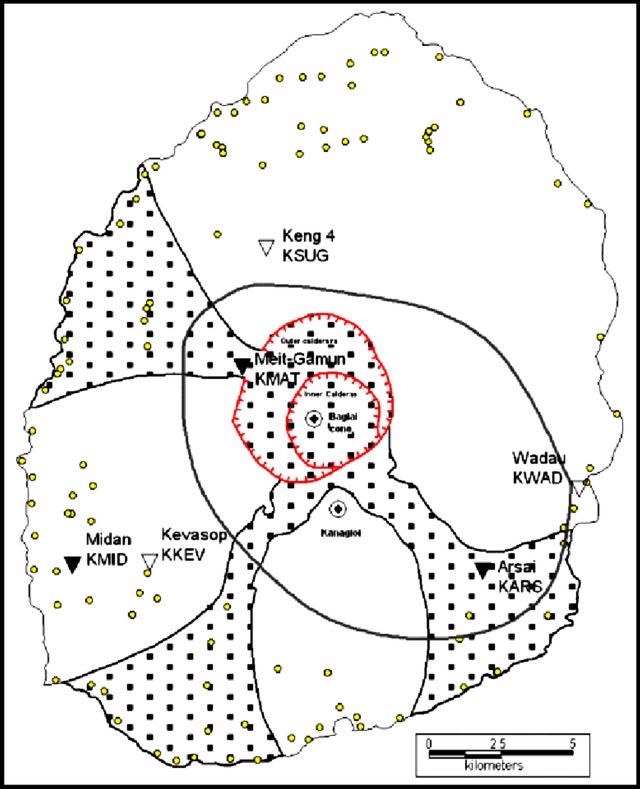 |
Figure 6. A map of the island of Karkar showing morphology. Open triangles indicate seismograph stations during 28-31 December 2007 (KSUG, KWAD, and KKEV). The filled triangles indicate seismograph stations during 24 January-3 February 2008 (KMAT, KARS, and KMID). The outlined oval-shaped region endorses the approximate area where the high-frequency earthquakes had epicenters. The regions decorated with square dots indicate channels, which provide possible pathways for mudflows and pyroclastic flows. Small dots villages, some of which lie within these channels. Courtesy of RVO. |
Bagiai cone continued to release variable volumes of white vapor towards the end of January 2008. A second phase of seismic monitoring at Karkar was carried on from 24 January to 3 February 2008. (figure 6, filled triangles). The closest seismometer to the cone was placed ~ 3 km away Seismic activity was low, dominated by high-frequency earthquakes, but low-frequency earthquakes also occurred. About 15?20 earthquakes were recorded daily during the first 3 days of recording (24-28 January), the earthquakes occurring near Bagiai cone in the center of the inner caldera.
The two phases of seismic monitoring detected both high-frequency volcano-tectonic (VT) earthquakes and low-frequency earthquakes. VT earthquakes were taken to indicate magma intrusion underneath or near Karkar volcano and were detected during the December 2007 deployment by two of the three stations (KWAD and KKEV) on the E and SE side. Station KSUG did not record the HF earthquakes.
The seismic monitor installed about 3 km from Bagiai cone (KMAT), at a spot adjacent to the thermal activity, recorded LF earthquakes as well. LF earthquakes were presumed to be associated with movement of steam and gas and the hydrothermal activity at Bagiai cone.
To provide continuous seismic monitoring at Karkar, on 3 February 2008 a portable seismic recorder was installed 9 km N of the cone. RVO intends to download and analyze the data every 2 months.
For several weeks during late February into early March 2008, RVO scientists visited Karkar to monitor the increased seismic activity first monitored during December 2007. Once again, the group reported that thermal activity from within the cone had caused the vegetation to die and turn brown. On this visit, withered and dry vegetation could be observed on Bagiai's flanks. Seismicity was continuing, but at low levels. On this visit, three portable seismic recorders were deployed close to the summit area on the outer caldera, 3.5 km from Bagiai. They recorded 15-20 volcanic earthquakes per day.
There have been no thermal anomalies measured over Karkar by MODIS instruments since at least the beginning of 2007 through mid-April 2008.
Geological Summary. Karkar is a 19 x 25 km forest-covered island that is truncated by two nested summit calderas. The 5.5 km outer caldera was formed during one or more eruptions, the last of which occurred 9,000 years ago. The steep-walled 300-m-deep, 3.2 km diameter, inner caldera was formed sometime between 1,500 and 800 years ago. Cones are present on the N and S flanks of this basaltic-to-andesitic volcano; a linear array of small cones extends from the northern rim of the outer caldera nearly to the coast. Recorded eruptions date back to 1643 from Bagiai, a pyroclastic cone constructed within the inner caldera, the floor of which is covered by young, mostly unvegetated andesitic lava flows.
Information Contacts: Herman Patia, Rabaul Volcanological Observatory (RVO), P.O. Box 3386, Kokopo, Papua New Guinea; MODVOLC Hawai'i Institute of Geophysics and Planetology (HIGP) Thermal Alerts System, School of Ocean and Earth Science and Technology (SOEST), Univ. of Hawai'i, 2525 Correa Road, Honolulu, HI 96822, USA (URL: http://modis.higp.hawaii.edu/).