Report on Jebel at Tair (Yemen) — April 2008
Bulletin of the Global Volcanism Network, vol. 33, no. 4 (April 2008)
Managing Editor: Richard Wunderman.
Jebel at Tair (Yemen) Eruptive cloud entered stratosphere; decaying thermal anomalies
Please cite this report as:
Global Volcanism Program, 2008. Report on Jebel at Tair (Yemen) (Wunderman, R., ed.). Bulletin of the Global Volcanism Network, 33:4. Smithsonian Institution. https://doi.org/10.5479/si.GVP.BGVN200804-221010
Jebel at Tair
Yemen
15.55°N, 41.83°E; summit elev. 244 m
All times are local (unless otherwise noted)
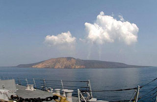
On 30 September 2007 an eruption began on the island of Jebel at Tair (BGVN 32:10) that generated a large SO2 plume, sent lava flows into the sea, and resulted in the deaths of Yemeni soldiers. Observations of continuing activity were made in late November-early December 2007, and also in mid-January 2008, but no other eyewitness reports have been received since that time. However, satellite data indicated continuing thermal anomalies, indicative of hot lava flows, into mid-May 2008.
Thermal anomalies detected by the MODIS instrument on the Terra and Aqua satellites were recorded daily from the beginning of the eruption through 14 January 2008 (figure 10). After that time the detections of anomalies became more intermittent, and fewer alert pixels were recorded each time. Only single-pixel anomalies were observed after 19 February, and the 19-22 February period was the last time anomalies were recorded for more than two consecutive days. Single anomalous pixels were later noted on 13 days from 26 February through May 2008, all apparently located on the N or NW slopes; the last one was on 18 May. [Another thermal anomaly was later detected on 14 June local time.]
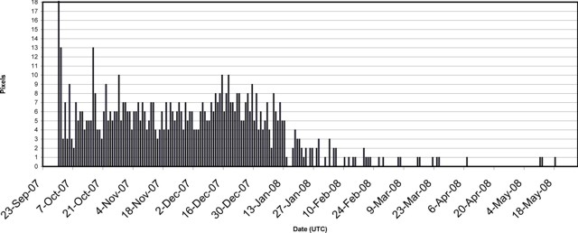 |
Figure 10. Plot showing the maximum number of daily MODVOLC thermal alert pixels detected at Jebel at Tair using MODIS data from Aqua and Terra satellites, September 2007-May 2008. Data courtesy of Hawai'i Institute of Geophysics and Planetology (HIGP) Thermal Alerts System. |
News media reports about the continuing eruption published in early December 2007 stated that at least eight soldiers had been killed during the initial activity on 30 September. Following a magnitude 2.7 earthquake in the Red Sea on 3 December reported by the Yemen Earthquake Observation Center (EOC), other officials were quoted as saying the eruption was "strong" with lava "shooting high in the air." The news stories also noted that two seismic stations had been installed on the Red Sea islands of Zuqar and Hunaish in late November 2007.
A later news report from 13 January 2008 indicated that a third seismic station was placed on the island of Kamaran. The 13 January story in the Yemen Times also included information from the head of the General Authority for Developing Yemeni Islands (GADYI), a government agency, indicating that "smoke steam" plumes were still rising from the crater.
Satellite data analysis. Eckhardt and others (2008) developed an "inverse modeling technique for estimating the vertical profile of SO2 emissions from a volcanic eruption, using total column measurements of SO2 from satellites and a Lagrangian particle dispersion model." Cloud-free satellite views of the 30 September 2007 eruption at Jebel at Tair and the long-range SO2 transport made for an "ideal" test case of the model. Modeling results will not be presented here, but the data analysis undertaken to initialize and test the model produced additional information about the eruption itself. The eruption began earlier than previously reported, and the plume reached stratospheric altitudes.
The onset of the eruption was not well documented, but soldiers reported entering the water to escape the eruption at 1530 local time (BGVN 32:10). By that time the water was described as "boiling" by survivors. Eckhardt and others (2008) looked for signs of the eruption onset using SEVIRI (Spinning Enhanced Visible and Infra-red Imager) satellite imagery (12µ channel). Their analysis of the temperature data suggested that the initial eruption took place before 1427 local time (1127 UTC). Temperature profiles also showed that the eruption cloud penetrated the tropopause, the atmospheric boundary found here at 15.3 km altitude (Eckhardt and others, 2008). Their initial eruption findings were summarized as follows: satellite observations combined with ECMWF (European Center for Medium range Weather Forecasting) and radiosonde profiles suggested an initial eruption no later than 1427; the plume reached neutral buoyancy no earlier than 1500; the minimum value of the 12µ brightness temperature was at 1557, and the plume reached an altitude above 16 km.
Total SO2 column measurements from AIRS (Atmospheric Infrared Sounder), OMI (Ozone Monitoring Instrument), and SEVIRI enabled Eckhardt and others (2008) to estimate a total emission of 80 (± 20) kt of SO2 into the atmosphere. Some instruments observed the plume dispersion for over a week, as it stretched across Asia and the Pacific Ocean.
Reference. Eckhardt, S., Prata, A.J., Seibert, P., Stebel, K., and Stohl, A., 2008, Estimation of the vertical profile of sulfur dioxide injection into the atmosphere by a volcanic eruption using satellite column measurements and inverse transport modeling: Atmospheric Chemistry and Physics Discussions, v. 8, p. 3761-3805.
Geological Summary. The basaltic Jebel at Tair volcano rises from 1,200 m depth in the south-central Red Sea, forming an oval-shaped island about 3 km long. It is the northernmost known Holocene volcano in the Red Sea and lies SW of the Farisan Islands. Youthful basaltic pahoehoe lava flows from the steep-sided central vent, Jebel Duchan, cover most of the island, draping a circular cliff cut by wave erosion of an older edifice and extending beyond it to form a flat coastal plain. Pyroclastic cones are located along the NW and S coasts, and fumarolic activity occurs from two uneroded scoria cones at the summit. Radial fissures extend from the summit, some of which were the sources of lava flows. Explosive eruptions were reported in the 18th and 19th centuries, prior to an eruption in 2007-2008.
Information Contacts: Hawai'i Institute of Geophysics and Planetology (HIGP) Thermal Alerts System, School of Ocean and Earth Science and Technology (SOEST), Univ. of Hawai'i, 2525 Correa Road, Honolulu, HI 96822, USA (URL: http://modis.higp.hawaii.edu/); Yemen Times (URL: http://yementimes.com/); Yemen Observer (URL: http://www.yobserver.com/).