Report on Chaiten (Chile) — April 2008

Bulletin of the Global Volcanism Network, vol. 33, no. 4 (April 2008)
Managing Editor: Richard Wunderman.
Chaiten (Chile) First recorded eruption generates large ash plume; thousands evacuated
Please cite this report as:
Global Volcanism Program, 2008. Report on Chaiten (Chile) (Wunderman, R., ed.). Bulletin of the Global Volcanism Network, 33:4. Smithsonian Institution. https://doi.org/10.5479/si.GVP.BGVN200804-358041
Chaiten
Chile
42.8349°S, 72.6514°W; summit elev. 1122 m
All times are local (unless otherwise noted)
The first historical eruption at Chaitén began on the morning of 2 May 2008, following increased seismicity in the region the day before. Chaitén, located W of the larger Minchinmávida (or Michinmahuida) stratovolcano, is a small 3-km-diameter post-glacial caldera or explosion crater (figure 1) which probably was formed ~ 9.4 ka BP, based on dating of scoria-rich surge deposits (Naranjo and Stern, 2004). Within the explosion crater lies an obsidian lava dome of rhyolite composition.
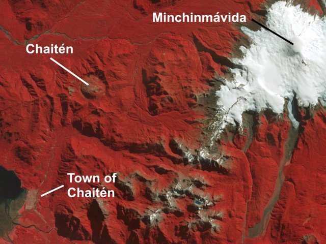 |
Figure 1. Orthorectified 15-m ASTER infrared (VNIR) satellite image from 1 April 2006 showing Chaitén volcano (upper left), ice-covered Minchinmávida volcano (right), and the town of Chaitén (lower left). Courtesy of Rick Wessels, Alaska Volcano Observatory. |
Servicio Nacional de Geología y Minería (SERNAGEOMIN) reported that a pulsating white-to-gray ash plume on 2 May rose to an estimated altitude greater than 21 km and drifted SSE. Based on observations of satellite imagery and pilot reports, the Buenos Aires VAAC reported an ash plume at altitudes of 13.7-16.8 km that drifted NE. According to news articles, Chile's government declared a state of emergency on 2 May and several hundred people were evacuated from the coastal town of Chaitén (10 km SE).
According to news sources, ashfall was reported during 2-6 May both locally and up to hundreds of kilometers away, affecting water supplies and roads. Based on observations of satellite imagery and pilot reports, the Buenos Aires VAAC reported that during 3-6 May ash plumes rose as high as 10.7 km altitude and drifted variably to the SE (figure 2), E, W, and NE. News sources indicated that about 4,000-5,000 people were evacuated from the town of Chaitén and surrounding areas as the eruption continued. On 5 May, ONEMI (Oficina Nacional de Emergencia - Ministerio del Interior) reported that evacuations also took place in Futaleufú, about 65 km ESE of Chaitén, where ~ 30 cm of ash accumulated. One elderly person died during the evacuation efforts. On 6 May, ONEMI and SERNAGEOMIN reported that the eruption became more forceful and generated a wider and darker gray ash plume rising to an estimated altitude of 30 km. All remaining people in Chaitén were ordered to evacuate, as well as anyone within 50 km of the volcano.
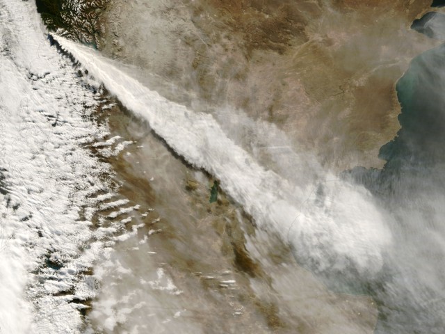 |
Figure 2. The Moderate Resolution Imaging Spectroradiometer (MODIS) on NASA's Terra satellite captured this image of a long, cloud-like plume extending about 700 km SE from Chaitén on 3 May at 1035 local time. The plume rises high over the Andes mountains, drifts across Argentina, and thins over the Atlantic Ocean. Courtesy of NASA Earth Observatory and the MODIS Rapid Response System. |
Activity continued, and a lava dome began growing from a vent on the upper flank of the old dome. Lahars and floods also inundated the town of Chaitén, causing widespread destruction. Additional details will be provided in future reports.
References. Naranjo, J.A., and Stern, C.R., 2004, Holocene tephrochronology of the southernmost part (42°30'-45°S) of the Andean Southern Volcanic Zone: Revista Geológica de Chile, v. 31, no. 2, p. 225-240.
Geological Summary. Chaitén is a small caldera (~3 km in diameter) located 10 km NE of the town of Chaitén on the Gulf of Corcovado. Multiple explosive eruptions throughout the Holocene have been identified. A rhyolitic obsidian lava dome occupies much of the caldera floor. Obsidian cobbles from this dome found in the Blanco River are the source of artifacts from archaeological sites along the Pacific coast as far as 400 km from the volcano to the N and S. The caldera is breached on the SW side by a river that drains to the bay of Chaitén. The first recorded eruption, beginning in 2008, produced major rhyolitic explosive activity and building a new dome and tephra cone on the older rhyolite dome.
Information Contacts: Servicio Nacional de Geología y Minería (SERNAGEOMIN), Avda Sta María No 0104, Santiago, Chile (URL: http://www.sernageomin.cl/); Oficina Nacional de Emergencia - Ministerio del Interior (ONEMI), Beaucheff 1637 / 1671, Santiago, Chile (URL: http://www.onemi.cl/); José Antonio Naranjo, Departamento de Geología Aplicada, SERNAGEOMIN; Buenos Aires Volcanic Ash Advisory Center (VAAC), Buenos Aires, Argentina (URL: http://www.smn.gov.ar/vaac/buenosaires/productos.php); Rick Wessels, Alaska Volcano Observatory, U.S. Geological Survey, Anchorage, AK, USA (URL: http://www.avo.alaska.edu/); NASA Earth Observatory (URL: http://earthobservatory.nasa.gov/); Associated Press (URL: http://www.ap.org/); Agence France-Presse (URL: http://www.afp.com/).