Report on Soufriere Hills (United Kingdom) — April 2008

Bulletin of the Global Volcanism Network, vol. 33, no. 4 (April 2008)
Managing Editor: Richard Wunderman.
Soufriere Hills (United Kingdom) Halt in dome growth during March 2007-May 2008
Please cite this report as:
Global Volcanism Program, 2008. Report on Soufriere Hills (United Kingdom) (Wunderman, R., ed.). Bulletin of the Global Volcanism Network, 33:4. Smithsonian Institution. https://doi.org/10.5479/si.GVP.BGVN200804-360050
Soufriere Hills
United Kingdom
16.72°N, 62.18°W; summit elev. 915 m
All times are local (unless otherwise noted)
Our previous report on Soufrière Hills characterized the eruptive behavior and monitoring between 16 June 2006 and 25 May 2007 (BGVN 32:04). The current report describes activity between the end of May 2007 through May 2008.
Summary report. A report of a 14 and 16 April 2008 meeting by an advisory committee provides a convenient summary of recent behavior (SAC10, 2008). With minor stylistic changes, important paragraphs are quoted below.
The report indicated that by about mid-March 2007 the volcano stopped extruding dome lava. The authors said that since about October 2007 volcanism at the surface of the volcano has been at a very low level. Further, they noted, "Whilst there have been no major collapses of the dome, or explosions, rockfalls and minor pyroclastic flows [traveling E] into the Tar River Valley have occurred that have eroded the eastern side of the dome. However, the main mass of the 2006-2007 lava dome remains intact, and whilst it remains so it is capable of generating major pyroclastic flows for years to come. Also, the flow of gas continues to stream through the dome from the magma deep in the Earth, forming the visible plume.
"A lidar survey of the shape of the dome undertaken in March 2008 gave an estimate of 195 million cubic meters for the volume of the dome. This figure is within the bounds of uncertainty of the volume estimate of 203 million cubic meters derived from photogrammetry in April 2007.
"The three distinct lobes of lava at the summit of the dome, present at the end of lava extrusion in April 2007, remain. There have been a number of rockfalls and a few minor pyroclastic flows from the dome into the Tar River Valley. As a result of these, the uppermost part of the talus has been removed on the eastern side exposing a steep band of core lava below which a chute channels material to lower levels. Similarly, erosion of talus has begun to re-expose the buried northern crater rim.
"Gases escape from the dome in several areas. On the southern and northern talus slopes multiple gas vents release mainly water-rich gas. Sulphur deposits are evident around the southern vents. These locations have been a common feature for much of the eruption. On the western side of the upper dome, just inside the buried Gage's Wall, is a vent releasing a large flux of gas with a pale blue tint, indicative of sulphur dioxide. This vent formed in February 2006 and has been the source of weak ash generation in the past, roaring noises, and the cause of minor erosion of the Gage's Wall (September 2006).
"The low levels of rockfall seismicity seen in 2007 declined even further during 2008. There were two minor swarms of long-period earthquakes on 23 November 2007 and 28 January 2008, the latter being co-incident with roaring from the Gage's Wall vent. Volcano-tectonic earthquakes occurred between the surface and 4 km below the dome. These may be caused by stress changes around the conduit.
"The reference GPS line between the South Soufrière (SOUF) and old MVO (MVO1) receivers continued the same extensional trend that began when extrusion stopped in April 2007. This extension is slower than the equivalent contracting trend seen during lava extrusion, but is comparable to the extension measured during the first year of the last pause in activity. This pattern is confirmed by most of the other GPS stations and the EDM lines on the northern side of the volcano. This extension is consistent with an island-wide pattern of surface inflation due to the magma reservoir re-charging at depth. Any deformation due to the effects of surface loading by the dome dies away over a much shorter distance from the volcano than that being monitored between MVO1 and SOUF.
"The lack of any fresh, degassing andesite magma high in the conduit was confirmed by low measured HCl/SO2 ratios. Sulphur dioxide was emitted at a rate above the long-term average (about 500 tonnes/day). Because several instruments in the measurement network have failed, there are some doubts about the absolute values, but a gradually increasing long-term trend seems real. This indicates not only that basalt degassing is ongoing, but also that the system may be becoming more permeable to deep gas loss or that gas production has increased. High values of sulphur dioxide measured by ground-based diffusion tubes to the west of the volcano have been recorded, as was also seen during the previous pause in 2005.
"Ongoing retrospective petrological analysis of the lava erupted over the last few years indicates that the amount of the basalt magma incorporated into the andesite lava that appears at the surface may be greater than previously appreciated. Understanding the mass balance of this interchange and being able to monitor it through time would help to understand the dynamics of the magma chamber.
"The current pause is 13 months long. Previous pauses have lasted 20 months (March 1998?November 1999) and 24 months (July 2003?August 2005). Despite the presence of a large dome, the "residual" surface activity now is far less than was the case during the first pause, when there was also a dome, and is much more like the second pause when there was no dome. The main difference between the first year of this pause and the first year of the second pause is the increasing trend of sulphur dioxide output in 2007-8. A few months prior to the ends of both previous pauses, the level of seismicity, and particularly long period seismicity, increased and there was a resumption of steam-rich explosions."
MVO and other reports. In accord with the summary above, the Montserrat Volcano Observatory (MVO) noted very low seismicity since May 2007. However, at the end of this reporting interval (May 2008), monitoring suggested that volcanic activity seemed headed for an upturn.
Despite the lack of dome growth (or dome destruction) during the entire period of this report the Alert Level remained at 4 (on a scale of 0-5). Authorities prohibited access to many areas near the volcano, including some areas ranging from 2 to 4 km offshore.
The Washington Volcanic Ash Advisory Center (W-VAAC) noted several ash plumes during mid-May 2007 through December 2007 (11 June, 22-28 August, 16 September, 12 October, 15-19 November) and 2008 (7 and 10 January, 10 April, 5 May, 13 -19, 23 and 29 May). Some of the plumes resulted from rockfalls (19 November, and 7 January).
Plumes on 11 June and 15-16 November may have reached 3.7 km altitude. Those on 13 and 29 May rose to 3 km altitude.
Pyroclastic flows were indicated in MVO reports for the May-December 2007 part of the reporting interval on at least 16 days. Particularly noteworthy were days with multiple pyroclastic flows, including 11 June (2), 23 August (4), and 29 November (4). The latter sequence of pyroclastic flows followed minutes after a regional M 7.4 earthquake. A 30 July pyroclastic flow traveled N for a 1.5 km runout distance.
Pyroclastic flows during January-May 2008 occurred on at least five days, and on one of those days, two occurred. One on 15 January had a 2 km runout distance. A pyroclastic flow on 29 May 2008 descended a few hundred meters to the W of the dome and was associated with the above-mentioned ash plume rising to 3 km altitude. An overflight the next day suggested that the explosion and pyroclastic flow originated from the Gages vent.
Lahars were indicated in MVO reports, often one or more per month and sometimes one or more per week, during the 2007-8 reporting interval, typically associated with heavy rains and fresh deposition. Lahars were numerous on 23 October 2007 (descending all drainages), vigorous around 25-26 October 2007, abundant the week of 13-19 February 2008, and noteworthy on 5 May 2008.
A photo shows the little-changing dome as it appeared on 7 January 2008 (figure 77). The photo emphasizes the dome's steep sides and craggy summit, as well as wide areas with emerging plumes. SAC (2008) noted that, although seemingly static, the dome is far from stable and large pyroclastic flows are possible from dome disruptions in the future. In the past, many of the pyroclastic flows traveled E. SAC (2008) noted the possibility (and discussed probabilities) for their transit from the dome towards the WNW along various areas just N of Plymouth.
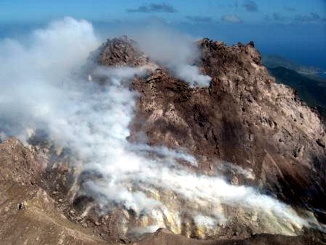 |
Figure 77. Photo of the Soufrière Hills lava dome taken on 7 January 2008 from the S with the crater rim in the foreground. Courtesy of Greg Scott, Caribbean Helicopters (from MVO website). |
According to MVO, the level of volcano-tectonic (VT) earthquakes at Soufrière Hills increased during the week of 25 April-2 May 2008, and was the highest since February 2006. During this week, degassing from a vent above Gages Wall was audible in the St. George's Hill area to the NW, and steaming from the area above Tyre's Ghaut to the NW was visible. Light ashfall was reported in the Old Town area about 9 km NW, and in other nearby areas.
During 9-19 May 2008, activity increased. On 13 May a single long-period earthquake occurred, accompanied by a blue sulfur-dioxide plume. An ash plume that rose to an altitude of 3 km drifted NW (dropping ash over much of Iles Bay, Belham, Old Town, and Olveston). Ash emissions from two areas in the Gages vent to the W were observed on 15 May, but may have started the previous day. The resultant ash plume rose about 200 m above the lava dome and drifted W. Both a small rockfall and gentle roaring noises were reported. A new fumarolic area was seen on the SE side of Chances Peak. Ash emissions from Gages vent continued on 16 May. During the week of 17-23 May, activity decreased slightly.
A weekly summary of seismicity and SO2 fluxes between 25 May 2007 and 30 May 2008 is indicated in table 65. In addition to the rockfall data in the table, there was one long-period rockfall event during each of the weeks of 23-30 November, 4-11 January, and 11-18 January. The long-term SO2 average is 550 tons/day.
Table 65. Soufrière Hills seismicity and sulfur dioxide flux between 25 May 2007 and 30 May 2008. Courtesy of MVO.
| Date | Hybrid EQ's | Volcano-tectonic EQ's | Long-period EQ's | Rockfall signals | SO2 flux (metric tons/day) |
| 25 May-01 Jun 2007 | 1 | 1 | -- | 5 | 230 |
| 01 Jun-08 Jun 2007 | -- | 1 | 1 | 5 | 175 |
| 08 Jun-15 Jun 2007 | -- | 1 | -- | 10 | 288 |
| 15 Jun-22 Jun 2007 | -- | 1 | 1 | 10 | 165 |
| 22 Jun-29 Jun 2007 | -- | 1 | -- | 3 | 203 |
| 29 Jun-06 Jul 2007 | -- | 1 | 1 | 10 | 200 |
| 06 Jul-13 Jul 2007 | -- | 1 | -- | 4 | -- |
| 13 Jul-20 Jul 2007 | -- | 1 | 1 | 6 | 300 |
| 20 Jul-27 Jul 2007 | -- | 3 | -- | 5 | -- |
| 27 Jul-03 Aug 2007 | -- | 2 | 2 | 11 | 639 |
| 03 Aug-10 Aug 2007 | -- | 2 | -- | 5 | -- |
| 10 Aug-17 Aug 2007 | -- | 2 | -- | 4 | 818 |
| 17 Aug-24 Aug 2007 | -- | 4 | -- | 4 | 509 |
| 24 Aug-31 Aug 2007 | -- | 13 | 1 | 17 | 740 |
| 31 Aug-07 Sep 2007 | -- | 1 | 1 | 7 | 575 |
| 07 Sep-14 Sep 2007 | -- | 5 | -- | 6 | 688 |
| 14 Sep-21 Sep 2007 | -- | 12 | -- | 8 | -- |
| 21 Sep-28 Sep 2007 | -- | 4 | -- | 9 | 300 |
| 28 Sep-05 Oct 2007 | -- | 1 | 2 | 3 | 384 |
| 05 Oct-12 Oct 2007 | -- | -- | -- | 10 | 508 |
| 12 Oct-19 Oct 2007 | -- | 5 | -- | 3 | 691 |
| 19 Oct-26 Oct 2007 | -- | -- | 1 | 9 | 518 |
| 26 Oct-02 Nov 2007 | -- | -- | -- | 9 | 618 |
| 02 Nov-09 Nov 2007 | -- | 12 | -- | 16 | 596 |
| 09 Nov-16 Nov 2007 | -- | 2 | -- | 11 | 698 |
| 16 Nov-23 Nov 2007 | -- | -- | 20 | 7 | 685 |
| 23 Nov-30 Nov 2007 | -- | -- | 46 | 4 | 868 |
| 30 Nov-07 Dec 2007 | -- | -- | -- | 4 | 405 |
| 07 Dec-14 Dec 2007 | -- | 1 | -- | 2 | 811 |
| 14 Dec-21 Dec 2007 | -- | 9 | -- | 2 | 865 |
| 21 Dec-28 Dec 2007 | -- | 4 | -- | 8 | 861 |
| 28 Dec-04 Jan 2008 | -- | 1 | -- | 2 | 615 |
| 04 Jan-11 Jan 2008 | -- | 8 | 1 | 2 | 513 |
| 11 Jan-18 Jan 2008 | -- | 13 | 2 | 3 | 568 |
| 18 Jan-25 Jan 2008 | -- | -- | -- | 2 | 734 |
| 25 Jan-01 Feb 2008 | -- | 3 | 25 | -- | 468 |
| 01 Feb-08 Feb 2008 | 1 | 3 | -- | 2 | 881 |
| 08 Feb-15 Feb 2008 | 1 | -- | -- | 1 | 1,004 |
| 15 Feb-22 Feb 2008 | 1 | -- | 1 | 1 | 872 |
| 22 Feb-29 Feb 2008 | 4 | -- | -- | -- | 972 |
| 29 Feb-07 Mar 2008 | 1 | 1 | -- | -- | 824 |
| 07 Mar-14 Mar 2008 | -- | 4 | -- | 3 | 766 |
| 14 Mar-21 Mar 2008 | 2 | 2 | -- | 3 | 1,070 |
| 21 Mar-25 Apr 2008 | -- | -- | -- | -- | -- |
| 25 Apr-02 May 2008 | -- | 48 | 3 | 1 | 574 |
| 02 May-09 May 2008 | -- | 10 | 5 | 5 | 630 |
| 09 May-16 May 2008 | -- | 25 | 1 | 17 | 506 |
| 16 May-23 May 2008 | -- | 3 | 2 | 11 | 653 |
| 23 May-30 May 2008 | -- | 8 | 2 | 10 | -- |
Since 2002, MVO has been monitoring the SO2 emission rate in real-time, with spectra telemetered back to the observatory from an array of three fixed, scanning UV spectrometers. MVO has also calculated the HCl:SO2 ratio by measuring the HCl emission rates indirectly using an open-path Fourier Transform Infrared spectrometer (FTIR). These ratios may be used to evaluate changes in the eruption rate and dome growth. Such mass ratios determined since August 2007 ranged from 0.28 to 0.46, with one ratio at 0.67 (during 9-16 November 2007).
MVO's weekly report for the third week of May states "observations show continuing unrest ... with a gradual increase over the last few weeks. The events of this week suggest that fresh magma is rising beneath the dome. There is now a distinct possibility that lava extrusion will start from the Gages vent without any warning. If this happens, it will probably not be long before there are small pyroclastic flows to the W. Even if lava extrusion does not restart, the dome is still a very large mass of very hot material which is capable of collapsing or exploding at any time."
Seismic signals. Five main seismic signal types have been recognized at many volcanoes, including Soufrière Hills. These include volcano-tectonic (VT) earthquakes, long-period (LP) earthquakes, hybrid earthquakes, rockfall or pyroclastic flow signals, and explosion signals. McNutt (2000) presents illustrations of characteristic seismic traces.
MVO defines a VT earthquake as having an impulsive (i.e., large amplitude) start and then rapidly decreasing in amplitude. These earthquakes often appear in swarms and are predominantly high-frequency signals (over 2 Hz). They are interpreted as due to rock fracturing.
An LP earthquake, as defined by MVO, has a more emergent start (i.e., amplitude growing with time) and generally low, narrow-band frequency content (1-2 Hz). These are interpreted as the result of signal resonance due to gas or magma inside the volcanic conduit.
MVO defines a hybrid (HB) earthquake as a mixture between VTs and LPs; hence they tend to have impulsive starts but contain significant amount of low-frequency signal. They are thought to represent magma forcing its way to the surface. These signals are often associated with periods of rapid dome growth, and are sometimes precursors to major dome collapses or switches in the direction of lava extrusion at the surface. These signals often merge into continuous tremor, which sometimes occurs in bands spaced 4-24 hours apart.
According to MVO, rockfall or pyroclastic flow signals have often been a dominant type of seismic signal recorded here (e.g., table 65). They have an emergent start and a gradual tapering towards the end of the signal and a wide frequency range. They are interpreted as being due to material falling off the dome and traveling down the flanks. Pyroclastic flow signals are similar to those of rockfalls but are generally of longer duration and higher amplitude.
Pyroclastic deposits in the ocean. Trofimovs and others (2006) reported that more than 90% of the pyroclastic material erupted at Soufrière Hills has been deposited in the ocean. The authors describe the characteristics of the deposits at different distances from shore. The coarse material forms steep-sided, near-linear ridges that intercalate to form a submarine fan. The finer materials form turbidity currents that flow to distances greater than 30 km from the shore.
MVO management. For almost 10 years the British Geological Survey (BGS) managed MVO. Beginning 1 April 2008, this service shifted to the Eastern Caribbean's two major geo-hazard organizations, the Seismic Research Unit (SRU) of the University of the West Indies, Trinidad and Tobago and the Institut de Physique du Globe de Paris (IPGP), France. The SRU carried out long-term monitoring prior to the 1995 eruption episode. They were assisted by others as the eruption began. A statement on the new situation included the following paragraph.
"The SRU monitors earthquakes and volcanoes for most of the English-speaking Eastern Caribbean countries. The IPGP has volcano observatories on Martinique and Guadeloupe, i.e. the main French-speaking Antilles. Island arcs such as the Lesser Antilles are regions where complex real-life hazards exist, not only the better known volcanic eruptions, but also the generation of a tsunami by a submarine earthquake or a volcanic landslide. The linking of these two research institutions will provide greater opportunities for studying volcanism and earthquake activity at arc-scale rather than the scale of individual islands, a logical and innovative step towards disaster risk reduction regionally and globally."
Reference. McNutt, S.R., 2000, Volcanic seismicity, in H. Sigurdsson (ed), Encyclopedia of Volcanoes, Academic Press, San Diego, p. 1015-1033.
Trofimovs, J., Amy, L., Boudon, G., Deplus, C., Doyle, E., Fournier, N., Hart, M.B., Komorowski, J.C., Le Friant, A., Lock, E.J., Pudsey, C., Ryan, G., Sparks, R.S.J., and Talling, P.J., 2006, Submarine pyroclastic deposits formed at the Soufrière Hills volcano, Montserrat (1995-2003): What happens when pyroclastic flows enter the ocean?: Geology, v. 34, no. 7, p. 549-552.
SAC10, 13 May 2008, Assessment of the hazards and risks associated with the Soufriere Hills volcano, Montserrat, Tenth Report of the Scientific Advisory Committee on Montserrat, Volcanic Activity, based on a meeting held between 14 and 16 April 2008 at the Montserrat Volcano Observatory, Montserrat (Part I: Main Report), 23 pp. (URL: http://www.mvo.ms/).
Geological Summary. The complex, dominantly andesitic Soufrière Hills volcano occupies the southern half of the island of Montserrat. The summit area consists primarily of a series of lava domes emplaced along an ESE-trending zone. The volcano is flanked by Pleistocene complexes to the north and south. English's Crater, a 1-km-wide crater breached widely to the east by edifice collapse, was formed about 2000 years ago as a result of the youngest of several collapse events producing submarine debris-avalanche deposits. Block-and-ash flow and surge deposits associated with dome growth predominate in flank deposits, including those from an eruption that likely preceded the 1632 CE settlement of the island, allowing cultivation on recently devegetated land to near the summit. Non-eruptive seismic swarms occurred at 30-year intervals in the 20th century, but no historical eruptions were recorded until 1995. Long-term small-to-moderate ash eruptions beginning in that year were later accompanied by lava-dome growth and pyroclastic flows that forced evacuation of the southern half of the island and ultimately destroyed the capital city of Plymouth, causing major social and economic disruption.
Information Contacts: Montserrat Volcano Observatory (MVO), Fleming, Montserrat, West Indies (URL: http://www.mvo.ms/); Washington Volcanic Ash Advisory Center, Satellite Analysis Branch (SAB), NOAA/NESDIS E/SP23, NOAA Science Center Room 401, 5200 Auth Road, Camp Springs, MD 20746, USA (URL: http://www.ssd.noaa.gov/).