Report on Home Reef (Tonga) — May 2008
Bulletin of the Global Volcanism Network, vol. 33, no. 5 (May 2008)
Managing Editor: Richard Wunderman.
Home Reef (Tonga) Pumice found on southeastern Papua New Guinea beaches
Please cite this report as:
Global Volcanism Program, 2008. Report on Home Reef (Tonga) (Wunderman, R., ed.). Bulletin of the Global Volcanism Network, 33:5. Smithsonian Institution. https://doi.org/10.5479/si.GVP.BGVN200805-243080
Home Reef
Tonga
18.992°S, 174.775°W; summit elev. -10 m
All times are local (unless otherwise noted)
Pumice from Home Reef has become one hypothesis for some mid-2007 observations on beaches in eastern Papua New Guinea, about 250-350 km NE of Milne Bay. The Rabaul Volcano Observatory (RVO) received a report about quantities of pumice on Woodlark Island beaches on 21 August 2007. The report was from the Deputy Administrator (DA) of Milne Bay Province who had been on election duty in a PNG Naval Patrol boat. The DA and the captain saw an echo sounder profile as they were sailing out of a lagoon at Budibudi Island (Lachland Islands) ~ 100 km ESE of Woodlark Island on the evening of 18 July 2007. They interpreted the profile as a possible submarine volcano. Later, they observed pumice clasts lying on the beaches of the Woodlark Islands. Recalling what they had seen on the echo sounder profile at Budibudi Island the previous day, the DA was very concerned that any activity the area would be a threat to the local population.
Additional information was gathered by RVO from the DA, government officers on Woodlark Island, and people from Budibudi Island. That investigation revealed no evidence of a pumice raft on Budibudi. Pumice clasts were only observed on Woodlark beaches, and images of pumice clasts showed that they were rounded and had incrustations. The lagoon at Budibudi also has no history of hydrothermal activity. There was also no evidence of continuous local earthquakes prior to or during July.
Simon Carn of the University of Maryland Baltimore County confirmed no evidence of anything unusual in the SO2 imagery. The UK Hydrographic Office provided scans of nautical charts of the remote islands, confirming that the site of the reported "eruption" was less than 35 m deep, so any activity would have been vigorous at the surface and obvious to Islanders.
It is assumed that the "submarine volcano" was a patch reef and the pumice was from the Home Reef eruption. Another alternative was that the pumice represented re-mobilized clasts from strand lines around the Solomon Sea, possibly a result of the 2 April Solomon Islands tsunami.
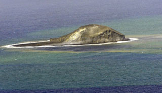
Geological Summary. Home Reef, a submarine volcano midway between Metis Shoal and Late Island in the central Tonga islands, was first reported active in the mid-19th century, when an ephemeral island formed. An eruption in 1984 produced a 12-km-high eruption plume, large amounts of floating pumice, and an ephemeral 500 x 1,500 m island, with cliffs 30-50 m high that enclosed a water-filled crater. In 2006 an island-forming eruption produced widespread dacitic pumice rafts that drifted as far as Australia. Another island was built during a September-October 2022 eruption.
Information Contacts: Herman Patia, Rabaul Volcano Observatory (RVO), P.O. Box 386, Rabaul, Papua New Guinea; Simon Carn, Joint Center for Earth Systems Technology, University of Maryland Baltimore County (UMBC), 1000 Hilltop Circle, Baltimore, MD 21250, USA (URL: https://so2.gsfc.nasa.gov/); Guy Hannaford, United Kingdom Hydrographic Office, Admiralty Way, Taunton, Somerset TA1 2DN, United Kingdom.