Report on Chaiten (Chile) — May 2008

Bulletin of the Global Volcanism Network, vol. 33, no. 5 (May 2008)
Managing Editor: Richard Wunderman.
Chaiten (Chile) Widespread rhyolitic ash; a dome then a tephra cone; destructive lahars
Please cite this report as:
Global Volcanism Program, 2008. Report on Chaiten (Chile) (Wunderman, R., ed.). Bulletin of the Global Volcanism Network, 33:5. Smithsonian Institution. https://doi.org/10.5479/si.GVP.BGVN200805-358041
Chaiten
Chile
42.8349°S, 72.6514°W; summit elev. 1122 m
All times are local (unless otherwise noted)
[Chaitén began erupting] on the morning of 2 May 2008 (BGVN 33:04). This report discusses events through 30 May, in particular, summarizing reports ("Noticias") issued by Servicio Nacional de Geología y Minería (SERNAGEOMIN). News and other reports have variously stated 8,000-12,000 people evacuated.
Impacts of ashfall in Argentina also spurred a local government report (Anonymous, 2008) noting that the Argentine Atomic Energy Commission analyzed tephra (pumice and ash) from ashfalls in Argentina. Results established the tephra as a low-silica rhyolite (table 1).
Table 1. Major element analyses (ranges for four samples) from Chaitén's ash. The samples were all from Argentina, at or near the settlements of Corovado (120 km SE of the volcano), Trevelin and Esquel (~100 km E), and Epuyén (~120 km NE). The values presented are weight percent (with total Fe shown as Fe2O3). In general, low silica rhyolites are typically about 69-74% SiO2; high-silica rhyolites, about 75-84%SiO2. Values here were measured by Laboratorio de Geoquímica de la Comisión Nacional de Energía Atómica, Regional Cuyo (Anonymous, 2008).
| Oxide | Range (wt. %) |
| SiO2 | 71.80-73.30 |
| Al2O3 | 13.50-14.35 |
| Total Fe as Fe2O3 | 1.43- 1.85 |
| CaO | 1.00- 2.50 |
| MgO | 0.30- 0.60 |
| Na2O | 4.40- 4.60 |
| K2O | 3.15- 3.30 |
| MnO | 0.04 |
| Total | 99.33-99.92 |
News reports during May (and later) stated that ash in and over Argentina closed airports. Many flights were also cancelled.
Chaitén volcano is in southern Chile, at the S end of Patagonia's Lakes district (figure 3). The evacuated town of Chaitén (figure 4) served as the provincial capital of Palena. The town was home to about 4,000 people, but lahars have buried at least portions of it. That town was also the main jumping-off point for Pumalin Park, a new nature sanctuary funded by philanthropist Douglas Tompkins.
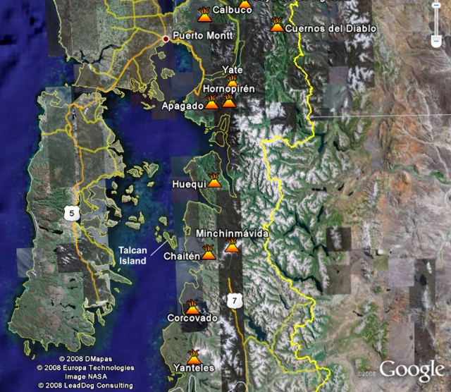 |
Figure 3. Map showing Chaitén volcano and other Southern Volcanic Zone volcanoes in Chile. The large island to the west is Chiloé Island. The passage at the N end of Chiloé island is called the Chacao strait; and the body of water it leads to is the Ancud gulf; farther S it becomes the Corcovado gulf. The city of Puerto Montt and major roads emphasize that the town of Chaitén lacks road access to the N. The town has an airport, but most residents evacuated by boat. Courtesy of Google Earth. |
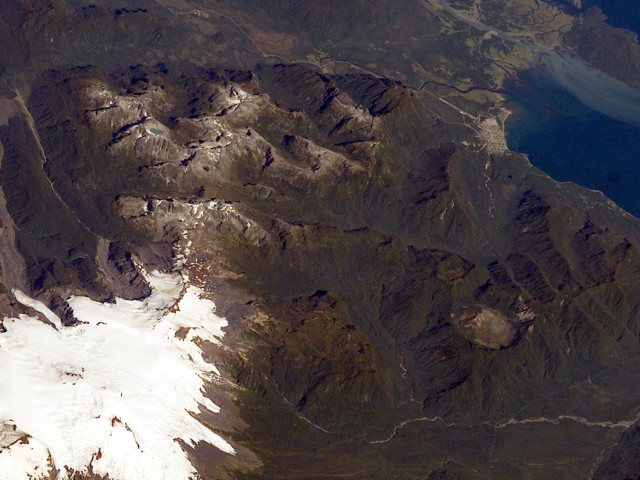 |
Figure 4. A pre-eruption photograph taken in 2003 looking downward and approximately SW from the International Space Station. Chaitén volcano sits in the lower right, with the larger snow-covered Minchinmavida at lower left. The Blanco river leads from the 3-km-diameter caldera towards the sea and passes through the town of Chaitén (top right), 10 km from the volcano. Photo ISS006E42130; courtesy of NASA. |
To the W of Chaitén town lies both the large (190 km long) Chiloé island and the much smaller Talcán island. Talcán island sits ~ 30 km from the town of Chaitén; it served as a staging area for monitoring efforts. Many of the larger rivers along the coast in the region reach the sea at fjords, and Chaitén town sits at the head of a fjord of the same name.
Synopsis of key events. Events during May included the month-long persistence of ash plumes; impressive electrical discharges coincident with some ash plumes; an ash blanket spanning cross-continent; some variable (and difficult to forecast) plume-dispersal patterns; small pyroclastic flows on multiple days; and lahars that progressively engulfed the town of Chaitén.
Some other highlights include the following. By 6 May, two explosion craters on the dome's N flank had united to form one large crater. By 21 May, aerial viewers saw a new dome had extruded in the N-central sector of the older rhyolite dome (figure 5). That new dome continued to grow through May, sprouting on the older dome, and later in the month, forming a large tephra cone. On 24 May, observers saw a vigorous eruption venting from an explosion crater on the old dome. They also noted that the new dome had grown taller than the old one. On 26 May, reports declared that the eruption had entered a less energetic phase (subplinean) with ash plumes rising 3-5 km in altitude.
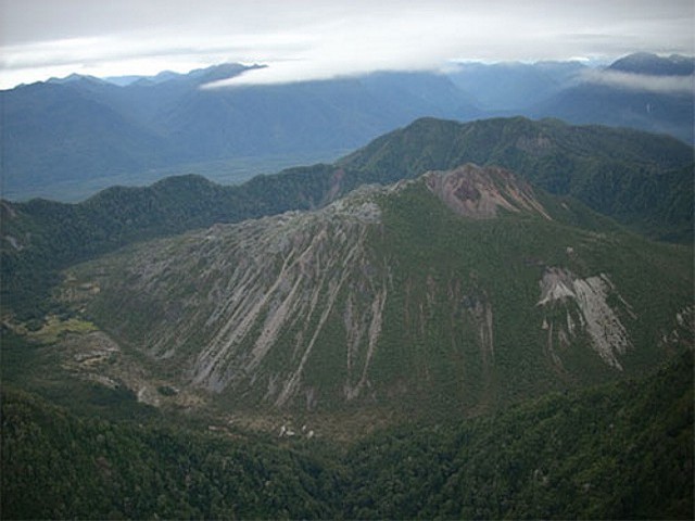 |
Figure 5. The dome-filled caldera of Chaitén volcano is seen in an aerial view from the S taken prior to the 2008 eruption. The elliptical 2.5 x 4 km wide summit caldera was formed during an eruption about 9,400 years ago. A rhyolitic, 962-m-high obsidian lava dome occupies much of the caldera floor. Photo by Eric Manríquez T. (Instituto Geográfico Militar). |
SERNAGEOMIN began to author reports on Chaitén starting the day the eruption began (2 May 2008, BGVN 32:04). Ten reports discussed May events. In addition, although little discussed in this report, the advent of digital and internet technology enabled eruption observers to share unprecedented numbers of photographs and videos. Satellite data on the eruption was also impressive (eg., NASA's Earth Observatory website featured 14 reports on Chaitén's May impacts).
Activity during 4-31 May. Amid reports of tall plumes on 3-6 May (BGVN 33:04), Andes del Sur (OVDAS) of SERNAGEOMIN installed three non-telemetered seismic stations around the volcano. These stations were later moved to more accessible places to enable more frequent data inspection. Improved seismic stations were installed later in the month (see below).
The 5 May eruptive vigor is partly revealed by an astronaut photo (NASA-ISS, 2008). Taken from a height of 344 km, it showed a plume punching through weather clouds and manifesting powerful vertical transport. It also highlights how weather clouds then would have thwarted ground observers from seeing, and thus assessing, the height of the plume top in those conditions.
Satellite imagery acquired on 5 May and discussed by NASA's Earth Observatory website that day revealed the Chaitén plume and a fresh blanket of ash. The ash blanket stretched from the high Andes to the Atlantic coast, and the ash plume continued E beyond it. Areas of the land surface along the Andes and to the Pacific were obscured by weather clouds.
The 6 May report noted that the eruption intensified at 0820 that day, leading to vigorous explosions of rhythmic character and high sustained energy. An ash column rose to ~ 30 km altitude. At this point in time, the column was taller and wider than those seen in the earlier, initial eruptive phase.
A helicopter flight at 1000 on the 6th indicated that two explosion craters on the dome's N flank had united to form one crater ~ 800 m in diameter. The column height had decreased. Consistent with mobile ash on the ground, the amount of ash in rivers in the region had increased.
After large explosions on 6 and 7 May, earthquakes occurred that were thought to denote moving fluid associated with a magma chamber beneath the volcano. Hypocenter calculations suggested the magma chamber was at less than 5 km depth. The ambient seismicity near the volcano around that time was ~ 35 volcano-tectonic earthquakes per day.
During 8 May, despite frequent low-hanging clouds, viewers glimpsed areas E of Chaitén. Along a N-trending valley there, thin gray spirals of cloud descended into the Rayas river, and ultimately the Rayas itself also began to emit clouds. SERNAGEOMIN's 9 May report explained these phenomena as the result of small pyroclastic flows inferred to have heated the river waters, thus yielding vapor that subsequently condensed to form the spirals of cloud.
The atmosphere, which on 8 May was cloudy during the hours 0715 to 1515, cleared somewhat during 1500-1630. At 1600 viewers saw both the volcano and a NE-blowing mushroom-shaped cloud that reached 14 km altitude. Photographic evidence (not included) showed that to the W side of the column there appeared a smaller cloud that looked denser and medium to dark gray. That smaller cloud was thought to have been associated with a new vent located at the foot of the dome's W side.
At 1300 on 12 May observers on Talcán island saw the upper portion of an ash column, which rose to 8.0 km altitude. Helicopter flights found strong SW winds aloft, blowing 80-100 km/hour to the NE. Despite the wind, during the flight about four explosions rose to similar (8 km) altitudes, thus sustaining the plume.
Aerial inspection of the caldera and dome at 1430 on 12 May revealed that small pyroclastic flows had burned multiple hectares of native forest in the headwaters of the Rayas river on the caldera's N flank and as far as the Austral highway. Similar processes had also devastated vegetation both everywhere within the caldera and on parts of the outer NE flanks. A wide, vertically oriented ash column originated from a vent extending from a crater on the older dome's N flank to its summit.
A photo of the caldera provided in the 13 May report showed a powerful billowing eruption. Incandescent areas spread along the dome's upper SE side, and a blanket of fresh fragmental deposits covered much of the upper dome.
On 12 May a helicopter crew found Chaitén town flooded by lahars traveling down the Blanco river. Based on the two photos in the report, the lahars at that point had covered roughly the lower half of single-story structures closest to the river and as far back as perhaps 3-5 buildings from those closest to the river's former margin. Some buildings closest the river were dislodged, a few had only their uppermost walls and roofs exposed. Significant portions of the town farther from the river still stood above the level of inundation.
Subsequent to 12 May, the river rose yet farther, and lahars took out a bridge. The lahars stretched ~ 200 m farther into the town reaching ~ 40 homes and numerous vehicles. Scenes of the town of Chaitén became the subject of many news reports and some videos posted on the web.
NASA's Earth Observatory posted an image acquired on 12 May (figure 6). Ash was again visible across the entire continent, spreading in a band trending ENE of the volcano. The ash is more visible in this image as the plume is blowing well S of the ash blanket.
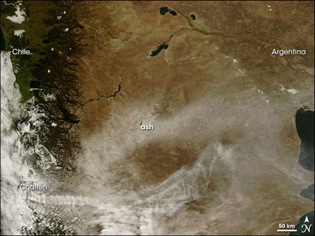 |
Figure 6. Chaitén's plume crosses the bottom of this Terra satellite image from 12 May 2008, becoming more diffuse before reaching the Atlantic coast. The ashfall blanket in an E-W cross-continent band. Courtesy of NASA Earth Observatory by Jeff Schmaltz and Michon Scott (their 12 May report). |
The 16 May report noted that the eruption was clearly plinean in nature and the source of continuous plumes. But, in the past two days, the plumes had not risen above 5 km altitude. Seismicity during 14-16 May included swarms of hybrid earthquakes.
At 0730 on 15 May observers saw the upper part of an ash plume reach 4 km altitude. The plume was swept NE in 140 km/hr winds. That day, a helicopter took observers over the town of Chaitén and the Amarillo and Michinmahuida rivers. Wide areas of the region were covered by white tephra. Lahars continued, apparent both to Chaitén's S and along the Blanco river to the coast. Lahars covered the Chaitén airfield and invaded the dock areas, as well as its main plaza, swamping government buildings. The lahars continued rising as the river bed and flood plains filled with sediments. Discolored water was seen widely (including N of Chaitén town in Pumalín bay,). Some elongate pumice rafts were floating in the Corcovado gulf.
In response to the crisis at Chaitén, during mid-May, the United States gave Chile several radio-telemetered seismic stations. Three members of the US Geological Survey (USGS) also joined SERNAGEOMIN and other agencies in Chile to install two stations. The visiting team, there during mid-May to early June, also discussed instrument operations, maintenance, and data interpretation.
The diagram in figure 7 indicates the key components of the portable seismic station initially used (without telemetry) and the new seismic stations installed (with digital instrumentation, telemetry, and linkage to the Internet). Both of the new seismic stations were installed on the mainland, broadcasting to a site on Chiloé island. Photographs of the area were taken during fieldwork (figures 8-10).
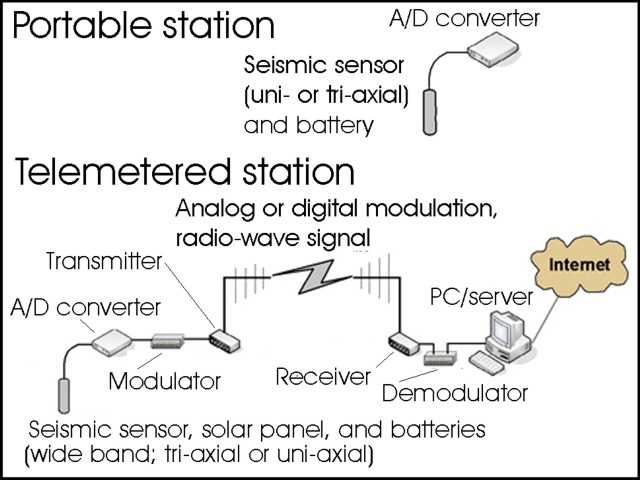 |
Figure 7. Diagrams comparing seismic stations and related components. At Chaitén, the portable stations were replaced by telemetered seismic stations during mid-May 2008. The A/D converter changes continuouos (Analog) signals to a stream of discrete (Digital) numbers. A "wideband" (broadband) seismic sensor can detect ground motions over wide frequency ranges compared to the narrower ranges typical of older instruments. These instruments also have a more uniform response across these varied frequencies, easing data interpretation. Courtesy of SERNAGEOMIN (from their 20 May report). |
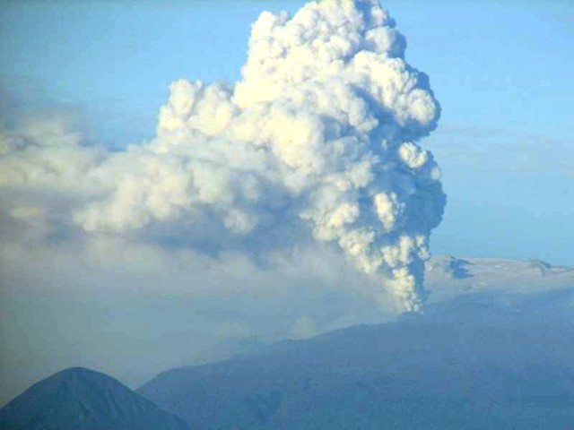 |
Figure 8. Chaitén eruption plume seen looking E across the gulf on 19 May 2008. The snow-covered flanks of Michimahuida volcano appear in the background. Courtesy of J.N. Marso (USGS). |
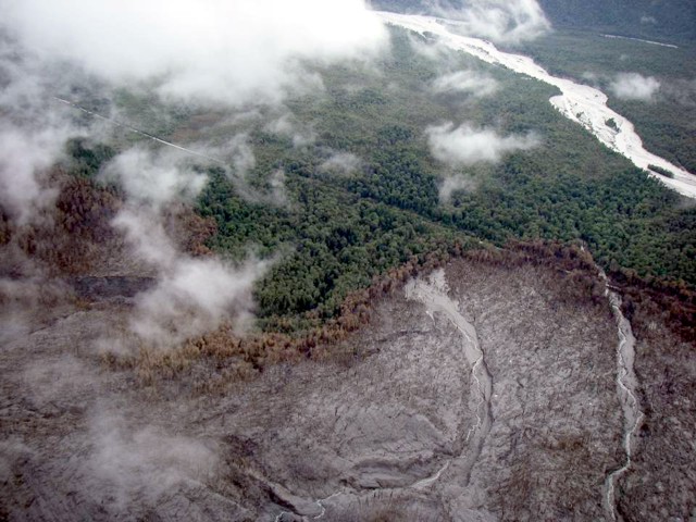 |
Figure 9. Native forest destroyed by pyroclastic surges on the flanks of Chaitén during mid-May to early June 2008. Note the singed band located between the zone of total destruction (bottom) and unaffected forest (top). A road is visible across much of the photo. Photo by A.B. Lockhart, USGS. |
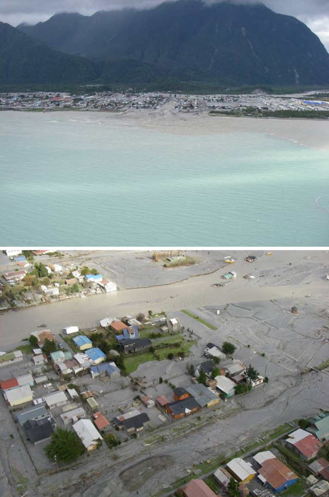 |
Figure 10. (top) Town of Chaitén overrun by lahars during mid-May to early June 2008. Lahars had began to accumulate as a delta at the river mouth. Owing to sedimentation, the river (seen in background) had changed course and was then flowing through the town. The airport is on photo's right side between the town and the steep hill in background. (bottom) This closer view illustrates variable amounts of lahar damage affecting Chaitén town. This town was completely evacuated within several days of the eruption's onset. Photos by A.B. Lockhart, USGS. |
At midday on 15 May, the authors described a cold wind that carried fine ash W. Ash fell on the ship Aquiles and on Talcán island, reaching 0.5-1.0 mm thick. In the same time frame, ash fell at the Blanco and Rayas rivers at least as far W as the Chaitén fjord's mouth.
Favorable weather, including strong wind, enabled scientists to assess the caldera on 21 May (figure 11). They found a new dome had emerged, already of significant size. It extruded from an area in the old dome. The eruption at the time was vigorous, though marked by sporadic explosions.
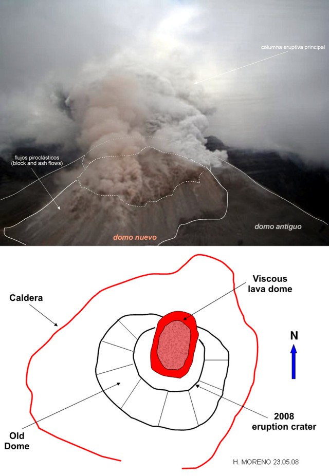 |
Figure 11. (top) An annotated photo from a helicopter on 21 May 2008 looking S into the erupting Chaitén caldera documenting the emergence of a new dome on the N side of the old one. The old dome (dark color, lower right) emitted a white plume; the new one (pale rose in colored versions of this photo, center) emitted a pale rose plume. Small block-and-ash flows descended the new dome's N side. The dark material in the background is the far (S) caldera wall. The venting ash column delivered considerable ashfall downwind. (bottom) A schematic (plan view) of the caldera seen that day (composed 23 May 2008 by H. Moreno). Both courtesy of SERNAGEOMIN. |
An overflight on 24 May revealed the new dome had slightly higher elevation than the old dome. Airborne observers saw the cone's 200-m-diameter crater vigorously expelling gas and ash. This vent was on the higher parts of the old dome in an area just to the S of the active dome.
The eruption, although unceasing, was described in the 26 May report as having decreased to subplinean. It remained in this lower energy state through at least month's end. On 25 May, ash columns reached ~ 3.5 km in altitude, with occasional explosions prompting plumes up to 5 km. Plumes often blew NE.
The 22 May report mentioned a swarm of hybrid earthquakes, in this case with considerable 3 Hz content. Volcano-tectonic earthquakes diminished progressively during 22-26 May, both in number and magnitude. These accompanied a reduction in volcanism.
A substantial tephra cone had developed on top of the new and old domes by 26 May (figure 12). The new dome, pink in color, was still present but lay directly behind the collar of tephra composing the new tephra cone. A summit crater vented plumes of different color. Although a dome had emerged, vigorous ash plume emission continued.
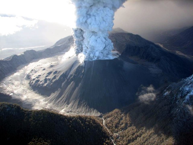 |
Figure 12. Chaitén seen from a helicopter on 26 May with the camera aimed NE. A tephra cone stood atop the new and old dome complex. The cone's steep upper walls discharged a broad plume from an unusually ample summit crater. The plume was two-toned, with distinctively shaded material on its left and right sides. Lumpy areas on the middle to lower cone correspond to the obsidian on the now buried older dome. Some burned vegetation exists in the bottom center of the photo along the outflowing Blanco river. Photo by J.N. Marso (USGS). |
A 26 May Terra image showed some areas of ashfall, but also several unusual features attributed to the eruption. These were described in the 26 May Earth Observatory report. First, rivers and lakes around the volcano were a distinct blue-green color, and this discoloration persisted into the Corcovado gulf, presumably from the waters' high suspended loads.
Second, although views of ridges (topographic highs) were clear and unobstructed in the image, a dendritic pattern of clouds, fog or mist hugged the valleys (topographic lows) for at least 200-300 km N and NE of the volcano. These white, opaque clouds originated from Chaitén.
On 28 May the ash column rose to 3.5-4 km altitude, blowing N to NW. It affected localities hundreds of kilometers away. Chilean airports closed in Puerto Montt, Osorno, Valdivia, and as far as 300 km N in Temuco. Lower altitude winds blew ash farther W, affecting coastal areas between the town of Chaitén and Chumildén, including Talcán island. In these areas, suspended ash appeared as a dense mist, grounding aircraft, including those used for vol;cano inspections.
During the last few days May, the number and magnitude of volcano-tectonic earthquakes diminished, and both low-frequency and hybrid earthquakes were absent. These changes coincided with a drop in the altitudes of eruption columns over the course of about a week.
Reference. Anonymous, 2008, Análisis químicos realizados en la contingencia del Volcán Chaitén: Municpalidad de Lago Puelo, 4 p. Accessed July 2008 (URL: http://www.lagopuelo.gov.ar/extras/riesgos/Analisis_quimicos_realizados_contingencia_Volcan_Chaiten[1].pdf).
Naranjo, J.A., and Stern, C.R., 2004, Holocene tephrochronology of the southernmost part (42°30'-45°S) of the Andean Southern Volcanic Zone: Revista Geológica de Chile, v. 31, no. 2, p. 225-240.
NASA-ISS, 2008, Astronaut photo from the International Space Station taken at 2027 on 5 May 2008 UTC. (Frame 6214, Mission ISS 017; file name, ISS017-E-6214.JPG). Image Science and Analysis Laboratory, NASA-Johnson Space Center (URL: http://eol.jsc.nasa.gov/scripts/sseop/photo.pl?mission=ISS017&roll=E&frame=6214>
Geological Summary. Chaitén is a small caldera (~3 km in diameter) located 10 km NE of the town of Chaitén on the Gulf of Corcovado. Multiple explosive eruptions throughout the Holocene have been identified. A rhyolitic obsidian lava dome occupies much of the caldera floor. Obsidian cobbles from this dome found in the Blanco River are the source of artifacts from archaeological sites along the Pacific coast as far as 400 km from the volcano to the N and S. The caldera is breached on the SW side by a river that drains to the bay of Chaitén. The first recorded eruption, beginning in 2008, produced major rhyolitic explosive activity and building a new dome and tephra cone on the older rhyolite dome.
Information Contacts: Servicio Nacional de Geología y Minería (SERNAGEOMIN), Avenida Santa María 0104, Santiago, Chile (URL: http://www.sernageomin.cl/); Oficina Nacional de Emergencia - Ministerio del Interior (ONEMI), Beaucheff 1637 / 1671, Santiago, Chile (URL: http://www.onemi.cl/); José Antonio Naranjo, Departamento de Geología Aplicada, SERNAGEOMIN, Avenida Santa María 0104, Santiago, Chile; NASA Earth Observatory (URL: http://earthobservatory.nasa.gov/); John Pallaster, Andy B. Lockhart, Jeff N. Marso, and John Ewert, US Geological Survey (USGS), Volcano Disaster Assistance Program (VDAP), 1300 SE Cardinal Court, Bldg. 10, Suite 100, Vancouver, WA 98683, USA; Image Science and Analysis Laboratory, NASA-Johnson Space Center, The Gateway to Astronaut Photography of Earth (URL: http://eol.jsc.nasa.gov/).