Report on Kasatochi (United States) — July 2008
Bulletin of the Global Volcanism Network, vol. 33, no. 7 (July 2008)
Managing Editor: Richard Wunderman.
Kasatochi (United States) Devastating SO2-rich ash eruption began on 7 August 2008
Please cite this report as:
Global Volcanism Program, 2008. Report on Kasatochi (United States) (Wunderman, R., ed.). Bulletin of the Global Volcanism Network, 33:7. Smithsonian Institution. https://doi.org/10.5479/si.GVP.BGVN200807-311130
Kasatochi
United States
52.177°N, 175.508°W; summit elev. 314 m
All times are local (unless otherwise noted)
Kasatochi, which apparently had not erupted during the last century, erupted explosively with little warning on 7 August 2008. The island is generally uninhabited, ~ 3 km in diameter, and lies ~ 800 km W of the tip of the Alaska Peninsula (figures 1 and 2). The eruptive history of this volcano includes several unconfirmed eruptions in the 1800's, and a small confirmed eruption in 1760. Much of the information in this report was taken from the Alaska Volcano Observatory (AVO) website or provided by John Eichelberger of the U.S. Geological Survey (USGS). No seismic or other geophysical monitoring instrumentation is present on Kasatochi. Seismic networks reside on neighboring islands, such as Great Sitkin Island ~ 40 km W.
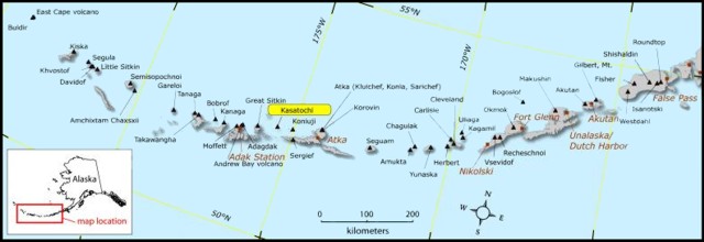 |
Figure 1. Map of Aleutian Islands showing locations of active volcanoes, including Great Sitkin, Kasatochi, Cleveland, and Okmok. Map prepared by Seth Snedigar, AVO/Alaskan Division of Geological and Geophysical Surveys. |
 |
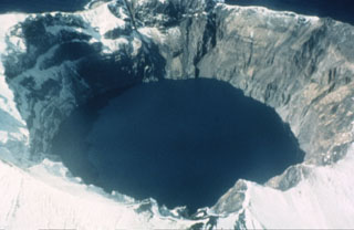
Figure 2. Photograph of Kasatochi as it appeared in 1961. The crater diameter was ~750 m. The (pre-eruption) crater-lake surface was less than 60 m above sea level. Courtesy of Dan Rogers, AVO/USGS. |
The first indication of activity on Kasatochi was around 2 August 2008, when a U.S. Fish and Wildlife Service (USFWS) field crew of two biologists on the island experienced continual small tremors. On 6 August, for a period of about 12 hours during the morning and afternoon, the AVO noted a rapid increase in earthquakes on the island. On the evening of 6 August, AVO elevated the aviation color code/volcano alert level to Yellow/Advisory.
By 7 August 2008, the number and magnitude of earthquakes increased, accompanied by volcanic tremor. Earthquakes as large as M 5.6 were detected. On the morning of 7 August, the field crew reported periods of continuous ground shaking lasting 5-10 min, as well as numerous rockfalls and a strong sulfur odor. Between approximately 1400 and 2035, three major explosions occurred. According to satellite data, ash reached an altitude of at least 13.7 km in the vicinity of Kasatochi, and drifted SSW.
The two biologists (Ray Buchheit and Chris Ford) were conducting a summer-long study of seabirds and living in a cabin on the island. According to Rozell (2008), the two were rescued by a charter boat captain only hours prior to the 7 August eruptions. After the earthquakes and other signs on the morning of 7 August, the biologists radioed their contact in Adak to explain the situation. The two fueled up their skiff and were prepared to jump in and follow a GPS course to Great Sitkin Island, heading across rough seas ~ 40 km W. But the refuge staff chartered a larger boat from Adak, which succeeded in getting the biologists off the island and to safety.
Between 2100 and 2300 on 7 August, observers from a ship near Kasatochi reported ashfall with tephra up to pebble size. They noted spectacular lightning, thunder, and total darkness during this time. In response to this eruptive activity, AVO elevated the aviation color code/volcano alert level to Orange/Watch and then to Red/Warning.
Ash emissions became continuous following the last of the three explosive events of 7 August, and (downward looking) satellite imagery disclosed a continuous ash cloud bent in a counterclockwise spiral. By 8 August, that plume had extended SE for more than 950 km at an altitude exceeding 10.7 km (figure 3).
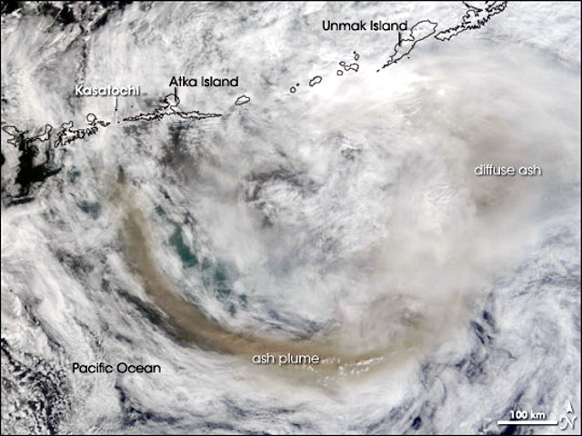 |
Figure 3. Image of plume from Kasatochi captured 8 August 2008 by the Moderate Resolution Imaging Spectroradiometer (MODIS) on NASA's Terra satellite. The bright clouds provide good contrast for the volcanic plume, which is dark brown. Weather patterns caused the plume to bend counterclockwise. Courtesy of NASA Earth Observatory. |
The eruption continued through 8 August and satellite imagery continued to detect a plume from Kasatochi until slightly after midnight on 9 August. By the morning of 9 August, seismicity declined and ash emissions were not observed in either satellite data or from pilots or passing mariners. The drifting SO2 plume was seen on satellite imagery 1,850 km ESE of the volcano. The plume was elongated NE-SW over a distance of 1,200 km.
During the days after 9 August, eruptive activity declined gradually. Seismic activity persisted at least through 5 September. The ash cloud produced during the previous week had detached and spread out over North America and was beginning to extend over parts of the North Atlantic. The distribution of gases and aerosols no longer appeared as a single intact cloud.
According to news reports on 10 and 11 August, Alaska Airlines had cancelled over 40 flights into and out of Alaska because of the ash plume. One report from Reuters stated that Alaska Airlines cancelled 44 flights. Those cancellations affected more than 5,200 passengers. According to an Anchorage Daily News report on 10 August, a member of Alaska Airlines staff was reported as saying, "The entire state is unflyable." The total number of flights cancelled by this and other carriers is unknown.
Occasional earthquakes and periods of tremor continued to be recorded. During 17-19 August, the smell of sulfur was reported from Adak, about 85 km SW of Kasatochi Island. Active fumaroles and hot pyroclastic-flow deposits over much of the volcano were observed on 22-23 August by visiting scientists (see below). On September 3 and 4, passing mariners observed vigorous steam and gas plumes rising above the crater and extending up to ~ 30 km downwind. On 4 September, the aviation color code/volcano alert level was reduced to Yellow/Advisory.
Sulfur dioxide measurements. On the days following the eruptions, the Ozone Monitoring Instrument (OMI) on NASA's Aura satellite tracked a dense cloud that contained about 1.5 megatons (million tons) of sulfur dioxide (SO2). This was one of the largest volcanic SO2 clouds scientists have observed from satellite measurements since the 1991 Pinatubo eruption in the Philippines. However, some fraction may be due to increased instrument sensitivity achieved since that time.
The three panels comprising figure 4 depict the early distribution of Kasatochi's SO2 plumes. The 8 August 2008 OMI image shows a highly-concentrated SO2 distribution E and SE. By 10 August the SO2 cloud had become elongate and sinuous, and had detached from the source. It extended S and SW but a long NW projection reached mainland Canada where it spread N and S to Alaska and Washington state. The zones of greatest SO2 concentration on 12 August appeared near the Yukon-Alaskan border. Areas of lower concentrations were complex but covered much of Canada and adjacent coastal areas at least as far as Greenland. A small outlier (not shown on map) was also present between Greenland and Iceland. The detached trailing edge resided over the N Pacific but farther S than in previous images.
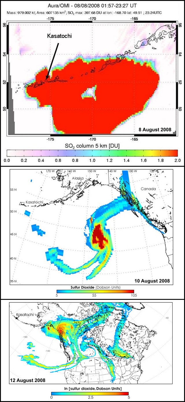 |
Figure 4. The SO2 cloud as measured by Ozone Monitoring Instrument (OMI) on NASA's Aura satellite on (top) 8 August 2008, (middle) 10 August 2008, and (bottom) 12 August 2008. Winds were moving the gas in a large counterclockwise loop over the Pacific Ocean and back toward Alaska, but also spreading streamers over the Arctic and eastward across the United States and Canada. Note the different scales for each image. A Dobson Unit is a commonly used measure of the concentration of a gas in a 15-km tall column of the atmosphere. Images courtesy of Simon Carn. |
Post-eruption visit. On 22-23 August 2008, Chris Waythomas (USGS/AVO) and Ray Bucheit (USFWS) visited the volcano. They observed numerous active fumeroles and hot pyroclastic-flow deposits. The entire island had been swept by surges and pyroclastic flows. Pyroclastic-flow, -surge, and fall deposits, in places containing boulders up to 2 m across, formed a new shoreline well beyond the pre-existing sea cliffs (figure 5). The visitors found no signs of life remaining on the island. The island's isolated ecosystem, which had been monitored by USFWS since the 1930s, had been totally destroyed.
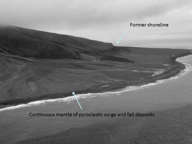 |
Figure 5. Fresh deposits of pyroclastic material form a new shoreline at Kasatochi. Courtesy of Chris Waythomas and Ray Bucheit. |
Figure 6 shows the extent of island's new shoreline and the new crater rim compared to the island's pre-eruption morphology. Newly deposited material extended the shoreline in a low-lying band around most parts of the island, in some places, ~ 300 m outboard of the pre-existing sea cliffs. In general, the crater rim expanded, particularly on the W side where it enlarged by ~ 200 m. A crater lake remained; and vents in the S crater were identified. During the visit, fresh slumps were apparent in fresh deposits perched on the crater rim and smaller "secondary" surge deposits were identified (figure 7).
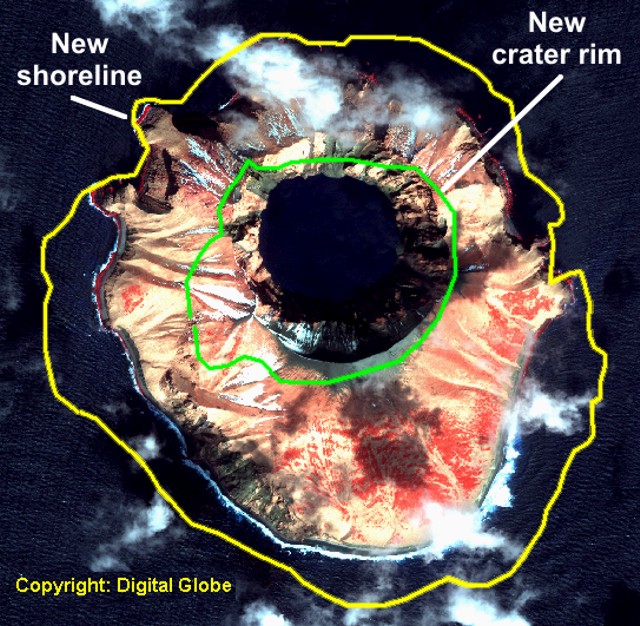 |
Figure 6. New shoreline (outer boundary) and new crater rim (inner boundary) found after the 7 August 2008 eruption of Kasatochi. The background (base) is a satellite image from April 2004 (Copyrighted by Digital Globe). Courtesy of John Eichelberger, USGS. |
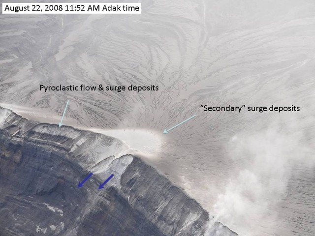 |
Figure 7. Aerial view of Kasatochi's crater rim, taken at 1152 on 22 August 2008 (with crater rim and upper wall cutting diagonally across the photo's left corner and the surface of freshly deposited tephra occupying most of the rest of the photo). During the visit, small (secondary) ash clouds and surges (light-colored areas) were produced by slope failure (in direction of at arrows down the crater wall). Photo courtesy of Chris Waythomas (AVO) and Ray Bucheit (USFWS). |
Thermal anomalies. According to David Schneider of AVO, thermal anomalies at Kasatochi were visible using a combination of MODIS, AVHRR, and GOES satellite sensors; increasing the number of satellite observations per day reduces the chance of missing anomalies due to cloud cover. The Hawai'i Institute of Geophysics and Planetology (HIGP) Thermal Alerts System measured no MODIS/MODVOLC thermal anomalies at Kasatochi during August and early September 2008. AVO measured thermal anomalies through breaks in the clouds on 5 September 2008 and during a relatively clear day on 7 September.
Reference. Rozell, N., 2008, Tiny Aleutian island has big impact: Alaska Science Forum, Article 1920, 13 August 2008 (URL: http://www.gi.alaska.edu/ScienceForum/ASF19/1920.html). (The Alaska Science Forum is a public service provided by the Geophysical Institute, University of Alaska Fairbanks, in cooperation with the UAF research community.)
Geological Summary. Located at the northern end of a shallow submarine ridge trending perpendicular to the Aleutian arc, Kasatochi is small 2.7 x 3.3 km island volcano with a 750-m-wide summit crater lake. The summit reaches only about 300 m elevation, and the lake surface lies less than about 60 m above the sea. A lava dome is located on the NW flank at about 150 m elevation. The asymmetrical island is steeper on the northern side than the southern, and the crater lies north of the center of the island. Reports of activity from the heavily eroded Koniuji volcano to the east probably refer to eruptions from Kasatochi. A lava flow may have been emplaced during the first recorded eruption in 1760. A major explosive eruption in 2008 produced pyroclastic flows and surges that swept into the sea, extending the island's shoreline.
Information Contacts: Alaska Volcano Observatory (AVO), a cooperative program of the U.S. Geological Survey, 4200 University Drive, Anchorage, AK 99508-4667, USA; Geophysical Institute, University of Alaska, PO Box 757320, Fairbanks, AK 99775-7320, USA; and Alaska Division of Geological & Geophysical Surveys, 794 University Ave., Suite 200, Fairbanks, AK 99709, USA (URL: http://www.avo.alaska.edu/); Hawai'i Institute of Geophysics and Planetology (HIGP) Thermal Alerts System, School of Ocean and Earth Science and Technology (SOEST), Univ. of Hawai'i, 2525 Correa Road, Honolulu, HI 96822, USA (URL: http://modis.higp.hawaii.edu/); NASA Earth Observatory (URL: http://earthobservatory.nasa.gov/NaturalHazards/); Simon Carn, Joint Center for Earth Systems Technology, University of Maryland Baltimore County (URL: https://so2.gsfc.nasa.gov/); Portland Business Journal (URL: http://portland.bizjournals.com/portland); Reuters (URL: http://www.reuters.com/).