Report on Suwanosejima (Japan) — September 2008
Bulletin of the Global Volcanism Network, vol. 33, no. 9 (September 2008)
Managing Editor: Richard Wunderman.
Suwanosejima (Japan) Eruption continues from 2007 into 2008
Please cite this report as:
Global Volcanism Program, 2008. Report on Suwanosejima (Japan) (Wunderman, R., ed.). Bulletin of the Global Volcanism Network, 33:9. Smithsonian Institution. https://doi.org/10.5479/si.GVP.BGVN200809-282030
Suwanosejima
Japan
29.638°N, 129.714°E; summit elev. 796 m
All times are local (unless otherwise noted)
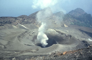
Historically, Suwanose-jima (figure 12) has been one of Japan's most frequently active volcanoes. Our last report on Suwanose-jima, (BGVN 33:02) listed ash plumes between 9 December 2007 and 21 March 2008. This report continues the list through 26 October 2008.
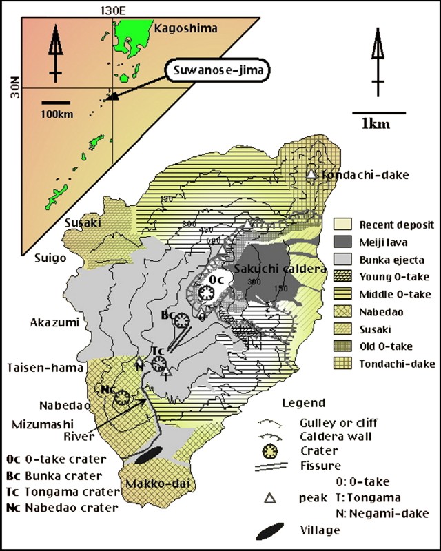 |
Figure 12. Simplified map of the geology of Suwanose-jima. The active crater, O-take (Oc), appears at the southern end of the small, sparsely populated island. Courtesy of Taketo Shimano. |
According to a 2008 International Civil Aviation Organization (ICAO) report, the Tokyo VAAC issued 70 volcanic ash advisories for Suwanose-jima during the 17-month period of January 2007-May 2008. This included seven from January through May 2008 (ICAO, 2008). Table 6 summarizes reports of explosive events and plumes for January-October 2008.
Table 6. A summary of Tokyo VAAC reports on explosive events and resulting ash plumes from Suwanose-jima from April through October 2008 (continued from table in BGVN 33:02). For some events, observers detected an explosion but were unable to observe a resulting plume. Courtesy of Tokyo VAAC, based on information from the Japanese Meteorological Agency (JMA) or pilot reports.
| Date | Plume Altitude (km) | Drift Direction |
| 16 Apr 2008 | -- | -- |
| 16 Jun 2008 | -- | -- |
| 29 Jul 2008 | 0.6 | S |
| 07 Aug 2008 | 1.2 | -- |
| 24-26 Aug 2008 | 1.8-2.4 | -- |
| 04-06 Sep 2008 | 1.5-1.8 | E (5 Sep) |
| 24-29 Sep 2008 | 1.5-3 | NE, E, and SW |
| 01-02 Oct 2008 | -- | -- |
| 07-10 Oct 2008 | 2.1 | -- |
| 16, 18-20 Oct 2008 | 1.2-2.5 | W |
| 21, 23, 25-26 Oct 2008 | 1.5-3.0 | W and E |
MODIS/MODVOLC thermal alerts were measured by satellite-borne radiospectroradiometer during 2008 through 6 November (table 7). The island is often covered by clouds, preventing consistent detections.
Table 7. Thermal anomalies measured by MODIS satellite analyzed by the MODVOLC algorithm for Suwanose-jima volcano in 2008 through 6 November. Courtesy of Hawai'i Institute of Geophysics and Planetology (HIGP) Thermal Alerts System.
| Date | Time (UTC) | Pixels | Satellite |
| 30 Jul 2008 | 1710 | 1 | Aqua |
| 31 Jul 2008 | 1335 | 1 | Terra |
| 22 Sep 2008 | 1350 | 1 | Terra |
NASA satellite observation of 19 October 2008. According to the NASA MODIS Rapid Response team and the NASA Earth Observatory, the volcano released a continuous plume of ash and steam in late October 2008. They noted that a Moderate Resolution Imaging Spectroradiometer (MODIS) captured an image of an ash plume on 19 October 2008. In this image, the plume formed a rippling pattern as it blew WSW. The plume differed from the nearby clouds in both its slightly darker color and more diffuse shape. Near the summit, the plume appeared beige.
References. International Civil Aviation Organization (ICAO), 2008, Fourth Meeting of the International Airways Volcano Watch Operations Group (IAVWOPSG), Paris, France, 15-19 September 2008: Working Paper 34, VAAC Tokyo Management Report, 6 p. (URL: http://www.icao.int/anb/iavwopsg/meetings/iavwopsg4/wp).
Geological Summary. The 8-km-long island of Suwanosejima in the northern Ryukyu Islands consists of an andesitic stratovolcano with two active summit craters. The summit is truncated by a large breached crater extending to the sea on the E flank that was formed by edifice collapse. One of Japan's most frequently active volcanoes, it was in a state of intermittent Strombolian activity from Otake, the NE summit crater, between 1949 and 1996, after which periods of inactivity lengthened. The largest recorded eruption took place in 1813-14, when thick scoria deposits covered residential areas, and the SW crater produced two lava flows that reached the western coast. At the end of the eruption the summit of Otake collapsed, forming a large debris avalanche and creating an open collapse scarp extending to the eastern coast. The island remained uninhabited for about 70 years after the 1813-1814 eruption. Lava flows reached the eastern coast of the island in 1884. Only about 50 people live on the island.
Information Contacts: Taketo Shimano, College of Environment and Disaster Research, Fuji-Tokoha University, 325 Obuchi, Fuji-shi, Sizuoka 417-0801, Japan (URL: http://www.eri.u-tokyo.ac.jp/shimano/); International Airway Volcanic Watch Operations Group of the International Civil Aviation Organization (URL: http://www.icao.int/anb/iavwopsg); Tokyo Volcanic Ash Advisory Center (VAAC) (URL: http://ds.data.jma.go.jp/svd/vaac/data/); NASA MODIS Rapid Response team, NASA Goddard Space Flight Center NASA; NASA Earth Observatory (URL: http://earthobservatory.nasa.gov/NaturalHazards); Hawai'i Institute of Geophysics and Planetology (HIGP) Thermal Alerts System, School of Ocean and Earth Science and Technology (SOEST), Univ. of Hawai'i, 2525 Correa Road, Honolulu, HI 96822, USA (URL: http://modis.higp.hawaii.edu/).