Report on Soufriere Hills (United Kingdom) — October 2008

Bulletin of the Global Volcanism Network, vol. 33, no. 10 (October 2008)
Managing Editor: Richard Wunderman.
Soufriere Hills (United Kingdom) Dome collapse and eruption on 28 July, followed by renewed dome growth
Please cite this report as:
Global Volcanism Program, 2008. Report on Soufriere Hills (United Kingdom) (Wunderman, R., ed.). Bulletin of the Global Volcanism Network, 33:10. Smithsonian Institution. https://doi.org/10.5479/si.GVP.BGVN200810-360050
Soufriere Hills
United Kingdom
16.72°N, 62.18°W; summit elev. 915 m
All times are local (unless otherwise noted)
Our previous report on Soufrière Hills (BGVN 33:04), characterized the eruptive behavior and monitoring of dome growth during March 2007-May 2008. The current report describes activity from the end of May 2008 through 4 December 2008.
Through the end of May, the Montserrat Volcano Observatory (MVO) generally reported continued pause in dome growth and low seismicity. An explosion on 29 May produced an ash plume that rose to an altitude of ~ 3 km and drifted SW; a pyroclastic flow descended a few hundred meters to the W. Aerial observation the following day suggested that the activity originated from the Gages vent. The explosion, which had no precursory seismicity, was heard in multiple areas to the NW.
Throughout June and the first three weeks of July, the background activity, while low, indicated continuing unrest. The pause in dome growth continued, but MVO emphasized that despite the lack of substantial lava extrusion, the dome remained hot and hazardous.
Mild ash was ejected from the Gages vent on 19 June. The event lasted for ~ 2 hours, and included several pulses. Due to strong E winds at low altitudes, the ash plume remained below ~ 1,200 m altitude and left Old Towne and Olveston untouched.
During mid- and late June, sporadic heavy rainfalls triggered minor mudflows down the Belham River. Access was accordingly prohibited. Also, a Maritime Exclusion Zone kept boats away from the island's S shore.
On 21 July, four mild eruptions occurred, typically venting ash or pyroclastic flows. The previous day there had been a large swarm of shallow volcano-tectonic earthquakes beneath the volcano and seismicity proceeded continuously throughout each of the first three eruptions. The first three eruptions lasted for about 50, 40, and 75 minutes, respectively. The third one generated the largest seismic signals, the fourth event was much smaller. Volcano-tectonic and hybrid seismic activity continued for the rest of the week without significant reduction. Small pyroclastic flows from collapses in the eroded chute on the dome's SE and E flanks traveled down the Tar River valley, with the largest reaching to within 500 m of the sea.
All four events generated ash columns rising more than 2 km. The first two events also generated ash clouds above the upper Tar River valley, probably caused by small pyroclastic flows. Ash clouds drifted W over Plymouth and St George's Hill; the source of the ash was probably the vent at Gages. Light ashfall occurred in parts of Old Towne. Rumbling, continuous at times, was heard in Salem, Old Towne and Olveston during each of the first three events. Lightning strikes could also be heard and sometimes seen. These events were most probably caused by ash venting from the lava dome, accompanied by small collapses on the E flank of the dome; however, there was no apparent change in the lava dome's shape.
After 20-25 July, seismicity increased significantly. On 26 July, a series of hybrid earthquakes slowly increased in both numbers and magnitude, eventually reaching about 15 events per hour. Seismicity decreased for a few hours, then increased again. Hybrid earthquakes with a few long-period events peaked at a rate of more than one per minute.
On the morning of 27 July, a short series of eruptions occurred. The first eruption generated a non-energetic ash column that rose ~ 2.5 km; the source of ash could not be seen due to cloud cover, but was probably the Gages vent. The ash cloud was blown to the W and NW, and there was ashfall in Plymouth and St George's Hill; pyroclastic flows were absent. Two other eruptions during the next 45 minutes were much smaller, with ash clouds below 1.5 km altitude. Seismicity continued at a slightly reduced level following these eruptions.
28 July dome collapse. On 28 July the seismic signals built up gradually over a few minutes, signals interpreted as consistent with a dome collapse rather than an explosion. Seismicity then displayed a series of sharp peaks consistent with explosive activity, but this activity stopped within about an hour. Next, there was a partial collapse on the dome's W side. A few explosions issued from the dome during the collapse. An infrasound sensor on St Georges Hill, which records low frequency sound waves, recorded a clear explosion signal that coincided with the largest peak recorded in the seismic signals.
The collapse generated three pyroclastic flows that traveled down the flanks. The largest, from the Gages area, split into two and traveled to Lee's Yard and Plymouth. A pyroclastic flow in Plymouth also split into two as it diverted around Round Hill, with a pyroclastic surge traveling over the top of the hill.
The two lobes of this W-traveling pyroclastic flow traveled almost to the sea, with one reaching the old Police headquarters and the other reaching the Pentecostal Church and the old Government House. This pyroclastic flow set fire to trees and vegetation on Gages Mountain, the lower flank of St George's Hill, and some buildings in Plymouth.
Another pyroclastic flow emerged from the channel created by erosion on the dome's SE flank. It descended E into the Tar River valley and traveled as far as the old Montserrat coastline. A much smaller flow followed a gully cut in volcanic material choking the upper White River; this flow only reached ~ 2 km or less from the dome.
Post-eruption examination of the deposits found that the pyroclastic flows at the Tar River appeared to contain significant amounts of old dome material, which would reflect the partial dome collapse. In contrast, the pyroclastic flows at both Plymouth and White River contained mainly juvenile pumice, material thought to have risen some distance in a plume.
The material collapsed from the dome on the 28th occupied a volume of ~ 200,000-300,000 cubic meters. Satellite radar images indicated that the vent above Gages wall was enlarged by the explosion to ~ 150 x 60 m, elongated E-W. MVO interpreted the 28 July eruption as caused by input of new magma, possibly triggered by the partial collapse of existing dome material.
MVO stated that the 28 July eruption generated a large ash column and the fallout of airborne pumice in nearby communities. The ash column reached a maximum altitude of ~ 12 km and drifted primarily NW. While almost no ash fell on inhabited areas near the volcano, there were reports of ashfall from St Croix, Puerto Rico, and Guadeloupe. Satellite sensors indicated the release of at least 2,000-3,000 tons of sulfur dioxide (table 66). Two minor eruptions on 29 July generated small ash clouds. During the period of this activity, the Washington VAAC published numerous advisories for aviation (table 67).
Table 66. Sulfur dioxide emissions were almost continuous during June-October 2008, and appear here as weekly averages and minimum/maximum values. Values are in metric tons/day. Courtesy of MVO.
| Date | AveraGE SO2 | Minimum SO2 | Maximum SO2 | Remarks |
| 31 May-06 Jun 2008 | 206 | -- | -- | -- |
| 07 Jun-13 Jun 2008 | 228 | 161 | 294 | -- |
| 14 Jun-20 Jun 2008 | 254 | 201 | 347 | -- |
| 21 Jun-27 Jun 2008 | 323 | 256 | 472 | -- |
| 28 Jun-04 Jul 2008 | 329 | 276 | 440 | -- |
| 05 Jul-11 Jul 2008 | 339 | 242 | 564 | -- |
| 11 Jul-18 Jul 2008 | 414 | 243 | 561 | -- |
| 18 Jul-24 Jul 2008 | 378 | 216 | 794 | -- |
| 25 Jul-01 Aug 2008 | -- | -- | -- | 2-3,000 tons SO2 released during the eruption on 28 July |
| 01 Aug-08 Aug 2008 | 1,121 | 671 | 2,069 | -- |
| 09 Aug-15 Aug 2008 | 1,016 | 364 | 1,791 | -- |
| 16 Aug-22 Aug 2008 | 1,122 | 274 | 2,033 | -- |
| 23 Aug-29 Aug 2008 | 466 | 239 | 758 | Data for 3 days |
| 30 Aug-05 Sep 2008 | -- | -- | -- | -- |
| 06 Sep-12 Sep 2008 | 1,422 | 562 | 4,599 | -- |
| 13 Sep-19 Sep 2008 | 989 | 657 | 1,217 | -- |
| 20 Sep-26 Sep 2008 | 1,239 | -- | -- | Data for 2 days |
| 26 Sep-03 Oct 2008 | 840 | 463 | 1,523 | -- |
| 03 Oct-10 Oct 2008 | 522 | 201 | 968 | -- |
| 10 Oct-17 Oct 2008 | -- | -- | -- | -- |
| 17 Oct-24 Oct 2008 | 531 | 277 | 668 | -- |
| 25 Oct-30 Oct 2008 | 1,283 | 689 | 2,540 | -- |
Table 67. Washington VAAC advisories as a result of ash plumes from Soufrière Hills during 21 July 2008-20 October 2008. All reports were based on GOES-12 satellite source information.
| Date | Time (UTC) | Altitude | Drift | Remarks |
| 21 Jul 2008 | 1145 | ~1.8 km | W | -- |
| 21 Jul 2008 | 1315 | ~1.8 km | -- | Plume to ~2 km; 16 km wide. |
| 21 Jul 2008 | 1915 | ~1.8 km | W, S | -- |
| 22 Jul 2008 | 0108 | -- | -- | Ongoing emissions. |
| 22 Jul 2008 | 0708 | ~1.8 km | W | Intermittent low level ash emissions. |
| 22 Jul 2008 | 1245 | ~1.8 km | W | Reduced seismicity. |
| 22 Jul 2008 | 1845 | ~1.8 km | W | -- |
| 27 Jul 2008 | 1345 | ~2.4 km | W | Small bursts of venting gases and ash; seismic signals increased. |
| 27 Jul 2008 | 1945 | ~2.4 km | W | Dome collapse event began. |
| 29 Jul 2008 | 0415 | ~12 km | W | Partial dome collapse on dome's W flank, accompanied by several explosions that generated ash plumes. Highest ash level noted at about 0340 UTC moving ESE. |
| 29 Jul 2008 | 0340 | ~12 km | SE | Weak hotspot in multi-spectral satellite data. |
| 29 Jul 2008 | 1215 | ~7.6 km | NW | Partial dome collapse 0327 UTC. |
| 29 Jul 2008 | 1815 | ~7.6 km | NW | -- |
| 30 Jul 2008 | 0615 | ~2.7 km | SW | Low-level emissions. |
| 30 Jul 2008 | 1215 | ~2.7 km | NW | Thin low level plume. |
| 30 Jul 2008 | 2345 | ~7.6 km | W | Residual ash and ongoing summit emissions. |
| 20 Oct 2008 | 1415 | ~5.5 km | NW | Ash associated with a pyroclastic flow. |
Monitoring dome shape and finding new rockfall material. The 6 August MVO report noted that the only significant change in the past few months occurred in the area of the Gage's Wall vent. That area was the source of ash and mild explosive activity in the last few months. During the first weeks of August seismicity was relatively low.
X-band radar images of the dome (figure 78) taken from different sides allow comparisons between 9 October 2007 and 1 August 2008. Images such as these help MVO interpret changes in topography and other features such as the surface texture of pyroclastic flows. Radar images provide data not available using optical techniques such as aerial photography or satellite imagery. For example, this image illustrates an effect called layover, where topography appears to lean. The images are also quite sensitive to the moisture content (affecting conductivity) and roughness of the ground surface (which scatters the radar energy).
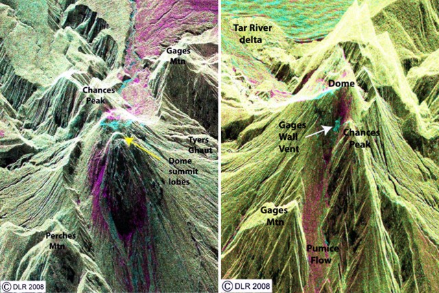 |
Figure 78. False-color satellite images with 2-3 m resolution showing Soufriere Hills from the E (left) and W (right) made to compare 9 October 2007 and 1 August 2008. These images used radar (TerraSAR-X, ~ 3 cm wavelength) data and provided views of such features as the 28 July 2008 pyroclastic flow deposits. In colored versions of these images, those 28 July deposits appear as magenta areas (rougher in 2007 than 2008). Similarly, the enlarged Gages Wall vent, which is best seen in the W view, is cyan-colored (rougher in 2008 than 2007). The image was made available to MVO thanks to the United Nations' International Charter, Geoff Wadge, and the German TerraSAR-X satellite. Courtesy of MVO. |
In the radar images color channels represent different points or intervals of time: red, 9 October 2007; green, 1 August 2008; and blue, the difference between those two dates. The result is that yellow areas depict terrain unchanged between those times. Areas of magenta had rougher surfaces in 2007 than 2008; areas that are cyan had rougher surfaces in 2008 than in 2007.
A new lava extrusion started from the W side of the lava dome sometime between the 28 July dome collapse event and 8 August when a new channel of fresh rockfall material was seen below Gages Wall.
On 14 August the dome's W side was visible and observers noted that the explosion crater of 28 July was almost filled with new lava and lava had spilled over the lower and W side of the crater and generated rockfalls.
On 8 August, the Government of Montserrat instituted a new Hazard Level System, which replaces the Alert Level system. The system divides the southern two-thirds of the island into six zones, and includes two Maritime Exclusion Zones. Access into each of the zones is restricted depending on the Hazard Level assigned (1-5); the current level has been set at 3.
During the week of 15-22 August, MVO found evidence of increased growth of the dome's W side. Earthquakes and rockfalls increased. Rockfalls occurred on the dome's W side in a new channel below Gages Wall. Ash plumes occasionally generated by the rockfalls were most noticeable on 16 and 17 August. On 19 August a pyroclastic flow again descended the Tar River Valley. According to news reports, on 25 August a rainfall-induced pyroclastic flow on the W flank split into two parts and caused ashfall to the N. The event enlarged and steepened the rockfall gully below Gages Wall. Lahars likely descended the Tar River Valley on 29 and 31 August.
On 1 September, a lahar descended the Belham River valley to the NW; the event lasted ~ 50 minutes. A new vent was observed on the NW part of the lava dome, a little further N of the Gages vent. Incandescence was also observed at a scar on the lava dome and in an area N of the scar. Rockfalls descended the W side of the dome. MVO reported that seismicity continued at a low level and dome growth continued throughout September.
During October, slow growth on the W side of the dome was accompanied by mudflows. As a result of slow and continuous erosion of the lower part of the dome, occasional rockfalls occurred on both the W side in the gully over Gages Wall and on the E side in the Tar River Valley.
One notable volcano-tectonic event occurred on 5 October in coincidence with the arrival of seismic waves from a M 6.6 earthquake in central Asia. Although the rate of lava extrusion had declined significantly, thermal imagery captured during an overflight on 8 October revealed that a major E-W oriented fracture in the dome, aligned with Gages valley and extending vertically over a few tens of meters, was associated with very elevated temperatures. Several other very hot areas on the dome were visible as points of incandescence that night. Also on 8 October, mobile, hot lahars were observed in Plymouth near the Pentecostal Church. This indicated that the 28 July pumice flows were still very hot.
Toward the middle of October, activity was low and consisted mainly of mudflows spurred by tropical storms that evolved to become hurricane Omar. Strong headward erosion affected the dome's talus slope on the Tar River side. A large gap developed in the talus, exposing the dome's core and forming a large vertical cliff.
Between 10-17 October, instrumentation recorded five long-period, five hybrid, and one volcano-tectonic earthquakes and only two rockfalls. By the third week of October, activity had increased slightly. Seismicity for the week consisted of 22 long-period, eight hybrid, and eight volcano-tectonic earthquakes, and two rockfalls. Incandescence was again observed from MVO on 17 October. On 20 October, three small pyroclastic flows descended to the Tar River Valley, generating small ash clouds that drifted over unpopulated areas to the W and SW. These pyroclastic flows were probably caused by the slightly increased seismic activity and continued interaction of the hot dome with water from the intense rainfall following passage of hurricane Omar. As of 24 October, there was no evidence of ongoing lava extrusion. Through the end of October, activity was at a low level. MVO recorded only four rockfalls, two long-period rockfalls, and one volcano-tectonic event. Several mudflow signals were also recorded during periods of heavy rainfall. Limited observations on 26 October confirmed that a few small pyroclastic flows traveled ~1.5 km E on the Tar River side.
Headward erosion continued along several V-shaped chutes at the base of the dome on both the dome's Tar River and SE sides. A small pyroclastic flow descended the Tar River (runout of ~ 1 km) on 27 October; it generated small ash clouds that drifted over unpopulated areas to the W, and to the SW. On the dome's W flanks, the talus pile on the Galways side developed a well-incised network of gullies leading into the White River.
On 2-5 December a series of explosions took place without clear seismic precursors. The first was the largest; MVO reported that incandescent blocks were ejected to 1 km from the dome's Gages vent. Pyroclastic flows began within 15 seconds of the first explosion's start at 0935 local time. They soon set vegetation and a few buildings into flames at Plymouth, and some of the fires continued for hours, one into the next day. The flows appeared devoid of pumice and were thought to be composed mainly of hot dome material. The event was judged smaller than the one on 28 July 2008, although the plume rose to over 10 km. The accompanying ash columns became the path for lightning strikes. Inhabited areas remained free of ash, which blew W. As of early December scientists had not assessed the impact of the 2 December events to the dome.
Geological Summary. The complex, dominantly andesitic Soufrière Hills volcano occupies the southern half of the island of Montserrat. The summit area consists primarily of a series of lava domes emplaced along an ESE-trending zone. The volcano is flanked by Pleistocene complexes to the north and south. English's Crater, a 1-km-wide crater breached widely to the east by edifice collapse, was formed about 2000 years ago as a result of the youngest of several collapse events producing submarine debris-avalanche deposits. Block-and-ash flow and surge deposits associated with dome growth predominate in flank deposits, including those from an eruption that likely preceded the 1632 CE settlement of the island, allowing cultivation on recently devegetated land to near the summit. Non-eruptive seismic swarms occurred at 30-year intervals in the 20th century, but no historical eruptions were recorded until 1995. Long-term small-to-moderate ash eruptions beginning in that year were later accompanied by lava-dome growth and pyroclastic flows that forced evacuation of the southern half of the island and ultimately destroyed the capital city of Plymouth, causing major social and economic disruption.
Information Contacts: Montserrat Volcano Observatory (MVO), Fleming, Montserrat, West Indies (URL: http://www.mvo.ms/); Washington Volcanic Ash Advisory Center, Satellite Analysis Branch (SAB), NOAA/NESDIS E/SP23, NOAA Science Center Room 401, 5200 Auth Road, Camp Springs, MD 20746, USA (URL: http://www.ssd.noaa.gov/); Caribbean Net News (URL: http://www.caribbeannetnews.com/).