Report on Alu-Dalafilla (Ethiopia) — December 2008
Bulletin of the Global Volcanism Network, vol. 33, no. 12 (December 2008)
Managing Editor: Richard Wunderman.
Alu-Dalafilla (Ethiopia) Lava flow-field size unchanged for months; thermal alerts ceased 28 December
Please cite this report as:
Global Volcanism Program, 2008. Report on Alu-Dalafilla (Ethiopia) (Wunderman, R., ed.). Bulletin of the Global Volcanism Network, 33:12. Smithsonian Institution. https://doi.org/10.5479/si.GVP.BGVN200812-221060
Alu-Dalafilla
Ethiopia
13.793°N, 40.553°E; summit elev. 578 m
All times are local (unless otherwise noted)
The eruption that began on 3 November 2008 (BGVN 33:10) significantly slowed or ceased prior to January 2009. The region is the scene of sporadic fighting, thwarting direct reports from people in the field, and forcing greater reliance on remote-sensing imagery.
Looking at Advanced Spaceborne Thermal Emission and Reflection Radiometer (ASTER) satellite system images for 19 December 2008 and 4 January 2009 (figure 9), Matt Patrick found little significant change in the shape or area of the lava flow field since 8 November 2008 (see image in BGVN 33:10).
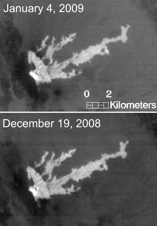 |
Figure 9. Satellite ASTER images over Dalaffilla and Alu volcanoes on 19 December 2008 and 4 January 2009. Shown are nighttime thermal images (band 14, 11-micron wavelength) showing flow to the NE from a fissure or fissure system between the volcanoes. Courtesy of Matt Patrick. |
Thermal alerts over the eruption site reported by the MODVOLC system were absent after 28 December 2008 (figure 10) through at least early February 2009. At the start of the eruption (identified on 3 November at 1920 UTC) there were 148 alerts in a circular pattern well extending outboard but engulfing the densest area of alerts over the main lava field. Following the initial eruption, the alert pixels concentrated primarily on the lava flow. No thermal anomalies were detected for at least several years before the November eruption.
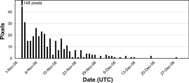 |
Figure 10. A plot of the maximum number of daily MODVOLC thermal alerts at Dalaffilla during November-December 2008. Courtesy of the Hawai'i Institute of Geophysics and Planetology (HIGP) Thermal Alerts System. |
NASA's Earth Observatory (EO) released a true-color image captured by Taiwan's Formosat-2 satellite (figure 11). The image caption, by Ralph Harrington, noted that fresh flows from the recent eruption appear darker than the older weathered flows. Lava spread from the fissure several kilometers to the NE, as well as S and SW. The image also appears to show spatter cones associated with the fissures.
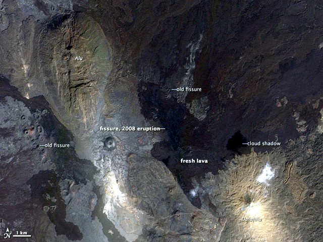 |
Figure 11. A Formosat-2 satellite true-color image (enhanced here) acquired 25 December 2008 of the Alu and Dalaffilla portion of the Erta Ale range of the Afar region. FORMOSAT-2, developed by the National Space Organization (NSPO), launched in 2004 with 2-m panchromatic resolution and 8-m multi-spectral resolution. Courtesy of NASA Earth Observatory, with image provided by Cheng-Chien Liu, National Cheng-Kung University, and An-Ming Wu, NSPO, Taiwan. |
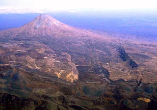
Geological Summary. The summit region of Alu, ~5 km NW of the Dalafilla stratovolcano, is an ellipsoidal volcanic horst, elongated NNW-SSE, and formed primarily of older basaltic lava flows. Recent fractures along the axis of the Erta Ale range cut the main horst of Alu and areas to the SSE. Fumarolic activity is located on the numerous parallel faults. Fissure vents west of the horst have fed silicic lava flows, and voluminous youthful basaltic lava flows to the east extend north as far as Lake Bakili. Dalafilla, also referred to as Gabuli, is a steep-sided cone that rises 300 m above surrounding lava fields due to extrusion of viscous, silicic lava flows. Basaltic lava flows from regional fissures surround the volcano. Fumarolic activity occurs in the 100-m-wide summit crater and has weathered surrounding lava flows. The first historical eruption of Alu-Dalafilla took place in 2008, when lava flows from vents between the two edifices traveled NE.
Information Contacts: NASA Earth Observatory (URL: http://earthobservatory.nasa.gov/); Ralph Harrington, The Volcanism Blog (URL: http://volcanism.wordpress.com); Matthew R. Patrick, Hawaiian Volcano Observatory (HVO), U.S. Geological Survey, PO Box 51, Hawai'i National Park, HI 96718, USA; Simon Carn, Department of Geological and Mining Engineering and Sciences, Michigan Technological University, 1400 Townsend Dr., Houghton, MI 49931, USA (URL: https://so2.gsfc.nasa.gov/); Hawai'i Institute of Geophysics and Planetology (HIGP) Thermal Alerts System, School of Ocean and Earth Science and Technology (SOEST), Univ. of Hawai'i, 2525 Correa Road, Honolulu, HI 96822, USA (URL: http://modis.higp.hawaii.edu/).