Report on Anatahan (United States) — December 2008

Bulletin of the Global Volcanism Network, vol. 33, no. 12 (December 2008)
Managing Editor: Richard Wunderman.
Anatahan (United States) Sulfur dioxide emissions and steam plumes during 2008
Please cite this report as:
Global Volcanism Program, 2008. Report on Anatahan (United States) (Wunderman, R., ed.). Bulletin of the Global Volcanism Network, 33:12. Smithsonian Institution. https://doi.org/10.5479/si.GVP.BGVN200812-284200
Anatahan
United States
16.35°N, 145.67°E; summit elev. 790 m
All times are local (unless otherwise noted)
The eruption at Anatahan (figure 32) had continued through February 2008 with intermittent eruptions (BGVN 32:12). This report covers 6 February 2008 into early January 2009 but also draws on an older reference on the status of coral reefs (Starmer, 2005). No thermal alerts have been measured by MODVOLC at Anatahan since 5 June 2006.
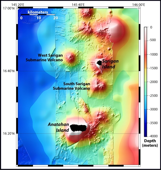 |
Figure 32. Location map showing Anatahan and Sarigan. The bathymetry data are a combination of satellite bathymetry overlaid with EM300 multibeam bathymetry, which was collected on the NOAA Submarine Ring of Fire 2003 cruise aboard the R/V Thompson. Courtesy of NOAA Ocean Explorer (modified from original). |
Ash plumes, SO2 emissions, and elevated seismicity continued between February and August 2008 (table 7). However, activity was consistently low after mid-August 2008. The last posted Volcanic Ash Advisories appeared on 1-3 August 2008. Throughout the reporting interval a key focus of reporting were episodes of sulfur-dioxide (SO2) emissions that drifted S to inhabited islands.
Table 7. Activity reported at Anatahan by week during 6 February 2008 to 31 January 2009. VAL is Volcanic Alert Level, ACC is Aviation Color Code. The VAL and ACC on 5 February 2008 had been raised to Watch and Orange, respectively, as a result of ash emissions. VHA is volcanic haze advisory. Data from the Emergency Management Office of the Commonwealth of the Mariana Islands, Hawaiian Volcano Observatory, and the Washington Volcanic Ash Advisory Center (VAAC).
| Date | Plumes and SO2 emissions | Seismic activity and other events |
| 06 Feb-12 Feb 2008 | Steam plumes, possibly with ash; SO2 emissions. | Relatively low seismicity, with short-lived increases. Volcanic fog near Saipan. |
| 13 Feb-19 Feb 2008 | Two SO2-bearing plumes; two steam plumes, possibly with ash. | Increased seismicity. |
| 20 Feb-26 Feb 2008 | Persistent SO2 emissions; steam plumes possibly with ash. | Elevated seismicity, with great variation. VHA issued for Tinian, Saipan, and Rota due to high SO2 levels. |
| 27 Feb-04 Mar 2008 | Persistent SO2 emissions; two ash plumes. | Elevated seismicity, some decline. VHA cancelled on 29 Feb. |
| 05 Mar-11 Mar 2008 | Ash and SO2-bearing plume, continuous ash emissions on 5-7 March. | Elevated seismicity, lower than previous week. |
| 12 Mar-18 Mar 2008 | Ash plume(s). | Variable seismicity, mostly somewhat elevated. |
| 19 Mar-25 Mar 2008 | Ash-and-gas plumes. | Elevated seismicity. |
| 26 Mar-01 Apr 2008 | None observed. | Low seismicity. VAL lowered to Advisory, ACC lowered to Yellow. |
| 02 Apr-11 Apr 2008 | None observed. | Low seismicity. |
| 12 Apr-15 Jul 2008 | -- | Reporting absent or sparse (apparently due to low activity; VAL lowered to Normal; ACC lowered to Green). |
| 16 Jul-22 Jul 2008 | SO2-bearing plume. | Slow increase in seismicity. |
| 23 Jul-29 Jul 2008 | SO2-bearing plumes, ash plume to 1.5 km altitude; plume possibly with ash. | Continued slow increase in seismicity. VAL at Advisory, then Watch; ACC at Yellow then Orange. |
| 30 Jul-05 Aug 2008 | Gas-and-steam plumes, possibly with ash at 1.5 km altitude. | Fluctuating seismicity. |
| 06 Aug-12 Aug 2008 | Small SO2-bearing plumes; steam plumes with ash to 1.8 km altitude. | Significant decrease in seismicity. VAL lowered to Advisory, ACC lowered to Yellow. |
| 13 Aug-31 Jan 2008 | No reports except in early October (no significant plumes). | Low seismicity. VAL lowered to Normal, ACC lowered to Green on 1 Oct. |
A Volcanic Haze Advisory was issued during the week of 20-26 February 2008 for the islands of Tinian, Saipan, and Rota due to high SO2 levels (see map, BGVN 28:04). According to an article on 26 February in the Saipan Tribune (Ferdie de la Torre, reporter), the Emergency Management Office of the Commonwealth of the Northern Mariana Islands (EMO-CNMI) advised people who had breathing problems to remain indoors during the volcanic haze advisory, and reminded mariners to take precautionary measures due to low visibility. The newspaper article indicated that EMO-CNMI's SO2 analyzer (location not reported) measured 161 ppb (parts per billion). According to the article, Gov. Benigno Fitial declared that Anatahan island was still unsafe for human habitation and ordered all travel to the island restricted, with the exception of scientific expeditions.
Starmer (2005) stated that "Ash fallout from the 2003 eruption caused extensive damage to nearshore reef habitats, especially on the northern side. Although all surveyed locations during the 2003 National Oceanic and Atmospheric Administration (NOAA) Marianas Research and Monitoring Program (MARAMP) cruise contained a layer of ash covering the substrate (figure 33), portions of the south shore and southeastern corner had only a veneer layer."
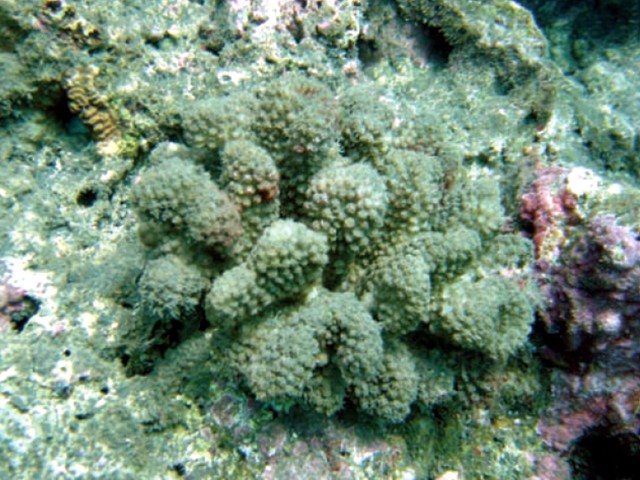 |
Figure 33. Part of an ash-covered coral reef on a submarine flank of Anatahan island. The reef organisms appear greenish gray in color owing to fine-grained ash. Taken from Starmer (2005). |
Reference. Starmer, J. (ed.) 2005, The state of coral reef ecosystems of the Commonwealth of the Northern Mariana Islands (p. 399-441) in Waddell, J.E. (ed.), 2005, The state of coral reef ecosystems of the United States and Pacific Freely Associated States 2005: NOAA Technical Memorandum NOS NCCOS 11, NOAA/NCCOS Center for Coastal Monitoring and Assessment's Biogeography Team, Silver Spring, MD, USA, 522 p.
Geological Summary. The elongate, 9-km-long island of Anatahan in the central Mariana Islands consists of a large stratovolcano with a 2.3 x 5 km compound summit caldera. The larger western portion of the caldera is 2.3 x 3 km wide, and its western rim forms the island's high point. Ponded lava flows overlain by pyroclastic deposits fill the floor of the western caldera, whose SW side is cut by a fresh-looking smaller crater. The 2-km-wide eastern portion of the caldera contained a steep-walled inner crater whose floor prior to the 2003 eruption was only 68 m above sea level. A submarine cone, named NE Anatahan, rises to within 460 m of the sea surface on the NE flank, and numerous other submarine vents are found on the NE-to-SE flanks. Sparseness of vegetation on the most recent lava flows had indicated that they were of Holocene age, but the first historical eruption did not occur until May 2003, when a large explosive eruption took place forming a new crater inside the eastern caldera.
Information Contacts: Emergency Management Office of the Commonwealth of the Northern Mariana Islands (EMO-CNMI), PO Box 100007, Saipan, MP 96950, USA (URL: http://www.cnmihsem.gov.mp/ and https://volcanoes.usgs.gov/nmi/activity/); Hawaiian Volcano Observatory (HVO), U.S. Geological Survey, PO Box 51, Hawai'i National Park, HI 96718, USA (URL: https://volcanoes.usgs.gov/observatories/hvo/); Washington Volcanic Ash Advisory Center, Satellite Analysis Branch (SAB), NOAA/NESDIS E/SP23, NOAA Science Center Room 401, 5200 Auth Rd, Camp Springs, MD 20746, USA (URL: http://www.ospo.noaa.gov/Products/atmosphere/vaac/); Saipan Tribune (URL: http://www.saipantribune.com); Hawai'i Institute of Geophysics and Planetology (HIGP) Thermal Alerts System (MODVOLC), School of Ocean and Earth Science and Technology (SOEST), Univ. of Hawai'i, 2525 Correa Road, Honolulu, HI 96822, USA (URL: http://modis.higp.hawaii.edu/); NOAA Ocean Explorer, Submarine Ring of Fire 2003 - Mariana Arc (Bob Embley, Principal Scientist) (URL: http://oceanexplorer.noaa.gov/).