Report on Ol Doinyo Lengai (Tanzania) — February 2009

Bulletin of the Global Volcanism Network, vol. 34, no. 2 (February 2009)
Managing Editor: Richard Wunderman.
Ol Doinyo Lengai (Tanzania) Comparative quiet during mid-2008 into January 2009
Please cite this report as:
Global Volcanism Program, 2009. Report on Ol Doinyo Lengai (Tanzania) (Wunderman, R., ed.). Bulletin of the Global Volcanism Network, 34:2. Smithsonian Institution. https://doi.org/10.5479/si.GVP.BGVN200902-222120
Ol Doinyo Lengai
Tanzania
2.764°S, 35.914°E; summit elev. 2962 m
All times are local (unless otherwise noted)
Recent reports on Ol Doinyo Lengai provided observations from several climbing groups and pilots after the energetic eruptions during 2007-early 2008, events which included extra-crater lava flows and Plinian-style eruption clouds with heavy ashfalls. In contrast, eruptions during the previous 40 years mainly remained confined to the summit crater. The latest reported observations were made during April-September 2008 (BGVN 33:08) .
Since then, owing to the increased difficulty and hazard of both ascent and close proximity to the volcano, tourism and consequent reporting has sharply dropped off. However, some brief reports summarizing the observations of guides that escorted hikers to the summit were available for October and December 2008, and January 2009.
A team of US and Tanzanian geologists assembled at the request of the Government of Tanzania reported on their investigations. That report includes photos of lava flows and an isopach map of 2007-2009 tephra deposits found W of the volcano. Some of those tephra deposits were 17 cm thick, and during September 2007-March 2008 tephra falls caused thousands of residents to evacuate. Many residents had returned by mid-January 2009.
D'Oreye and others (2008) used synthetic aperture radar interferometry (InSAR) to study the geodetic behavior of several African volcanoes. They identified co-eruptive deformation at Lengai as well as a rift diking event in northern Tanzania.
Ascents and views of summit behavior. On 6 October 2008 French and Belgian climbers guided by Burra Amigadie observed a large mass of rock collapse into the active N crater. The mass fell from the crater's inner N wall. On 12 October 2008 climbers guided by Olomelok Naandato heard strong thundering noises and sensed tremors while ~ 150 m from the peak. On 26 October, thick steam from the crater was seen from a distance. The local government advised people not to climb the mountain until the situation normalized.
On 27 December 2008 ejection of the steam had subsided significantly and the mountain was considered generally calm despite small, periodic ash showers. Mountain climbing resumed. During 7-12 January 2009 climbers saw short-lived fumaroles emanating from the crater accompanied by moderate roaring sounds and tremors.
USGS and Tanzanian joint visit. During 18-22 January 2009 a team investigated the recent volcanism's impact. The team's members (see Information Contacts) came from the US Geological Survey (USGS) and US Agency for International Development, Office of Foreign Disaster Assistance, Volcano Disaster Assistance Program (VDAP); they joined geoscientists from the Geological Survey of Tanzania (GST) and Disaster Officials from the Disaster Management Department in the Prime Minister's Office. During their stay near Lengai, the team noted a small amount of steam occasionally rising from the N crater, and narrow plumes of white steam over the northern uppermost slopes.
The September 2007-March 2008 tephra falls covered an area predominantly to the W (figure 117). A few ash-thickness measurements were collected there across the trend of the September 2007-March 2008 tephra falls. Thicknesses as great as 17 cm were found 4 km from the vent (figure 118).
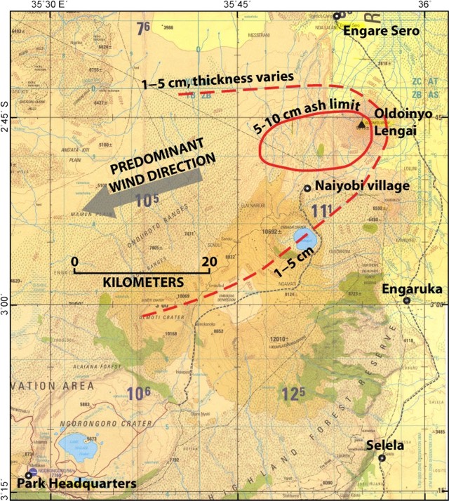 |
Figure 117. Map showing the distribution of ash from 2007 and 2008 eruptions of Ol Doinyo Lengai. Courtesy of the US-Tanzanian team. |
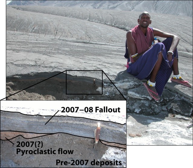 |
Figure 118. Photograph and annotated enlargement illustrating an exposed section of W-flank deposits from 2007-2008 Ol Doinyo Lengai eruptions. Fallout in this area completely buried vegetation. The photograph was taken 19 January 2009. Courtesy of David Sherrod (USGS). |
Lava flows deposited on the W flank in 2006 reached 200 m wide at the point of greatest breadth and extended 4.4 km downslope from the summit, terminating at ~ 1,230 m elevation. Where visited, the flows' surface textures were mostly pahoehoe with patches of a'a 3-5 m thick (figure 119). Trees caught in the lava flows remained standing and largely uncharred (figure 120), providing evidence that the lava flows were at or below the ignition temperature for vegetation.
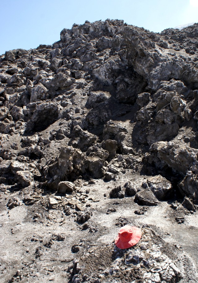 |
Figure 119. A'a flow deposited during a 2006 eruptive episode on Ol Doinyo Lengai's NW flank. Note the hat for scale (in foreground). USGS photo taken by Gari Mayberry on 19 January 2009. |
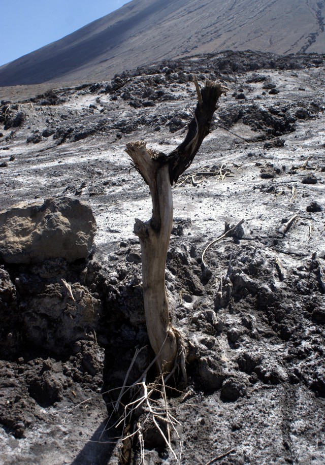 |
Figure 120. A tree remains standing in the 2006 lava flow from Ol Doinyo Lengai on the W flank. The lava flow was not hot enough to ignite the tree, an observation consistent with the lava chemistry. Photographed on 19 January 2009 by Gari Mayberry. |
A guide who ascended Lengai the morning of 20 January 2009 saw active lava flows on the NE portion of the N crater's floor.
On 22 January team members traveled to the village of Naiyobi, in the Ngorogoro Conservation Area ~ 12 km SW of the summit. Naiyobi, and the neighboring village of Kapenjiro (15 km S of the volcano). Residents were evacuated from these villages during the height of activity. According to the area coordinator, by January 2009 thousands of people had returned to both villages. Ash thicknesses measured on 22 January at a location 5.6 km NW of Naiyobi village were 5-6 cm (figure 121).
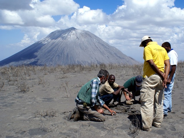 |
Figure 121. With Ol Doinyo Lengai in the background (6.5 km NE), USGS and GST scientists assess ash thickness at a location 5.6 km NNW of Naiyobi village. Taken 22 January 2009 by Gari Mayberry. |
The US team had an interview that was featured on the web (Ransom, 2009). They noted the comparative repose seen during 2008 and that fewer than 10,000 people live within 10 km of the volcano. The rainy season (May-October), had passed by the time the US-Tanzanian team had arrived, and grass had begun to grow on previously ash-covered surfaces. Despite the emergence of these grasses, the team expected that next rainy season(s) will probably trigger mudflows and flash floods. This would impose periods of days when vehicles would be unable to reach the small communities around the volcano.
Gari Mayberry noted "The International Volcano Health Hazard Network has produced some pamphlets that discuss how to deal with ashfall. We are going to work with our colleagues from the University of Dar es Salaam in Tanzania who have offered to translate these pamphlets into Swahili so that local people ... can learn more about how they can deal with this hazard. It may go on to be translated into Maa, the local Masai language."
In discussing the lack of monitoring they noted that circumstances, "... forced us to look at the situation in a new way and to determine that disaster risk reduction education may be the most feasible way to reduce the hazard because it will be quite difficult due to the lack of infrastructure ... to install monitoring equipment."
They also commented that the unique carbonatite lavas are "so low on the temperature scale that it almost doesn't glow red. It has a hard time igniting trees or grasses as it flows over it because it's right at the point of ignition temperature from any of the things that grow on the surface ...."
References. D'Oreye, N., Fernandez, J, Gonzalez, P, Kervyn, F, Wauthier, C, Frischknecht, C, Calais, E, Heleno, S, Cayol, V, Oyen, A, Marinkovic, P, 2008, Systematic InSAR monitoring of African active volcanic zones: What we have learned in three years, or an harvest beyond our expectations: Dept. of Geophys./Astrophys., Nat. Museum of Natural History, Walferdange, in Second workshop on use of remote sensing techniques for monitoring volcanoes and seismogenic areas, 11-14 November 2008, p. 1-6, ISBN: 978-1-4244-2546-4
Ransom, C. N., 2009, Tanzanian Villagers Encouraged to Learn Hazards of Living Near Erupting Volcano, US Geological Survey; Audio interview taken 5 March 2009 (with transcript): USGS Interviews Collection (URL: http://gallery.usgs.gov/audios/244).
Geological Summary. The symmetrical Ol Doinyo Lengai is the only volcano known to have erupted carbonatite tephras and lavas in historical time. The prominent stratovolcano, known to the Maasai as "The Mountain of God," rises abruptly above the broad plain south of Lake Natron in the Gregory Rift Valley. The cone-building stage ended about 15,000 years ago and was followed by periodic ejection of natrocarbonatitic and nephelinite tephra during the Holocene. Historical eruptions have consisted of smaller tephra ejections and emission of numerous natrocarbonatitic lava flows on the floor of the summit crater and occasionally down the upper flanks. The depth and morphology of the northern crater have changed dramatically during the course of historical eruptions, ranging from steep crater walls about 200 m deep in the mid-20th century to shallow platforms mostly filling the crater. Long-term lava effusion in the summit crater beginning in 1983 had by the turn of the century mostly filled the northern crater; by late 1998 lava had begun overflowing the crater rim.
Information Contacts: B.H. Shabani and Ms Sofia, Disaster Management Department, Prime Minister's Office, United Republic of Tanzania; Abdulkarim Mruma and Elikunda Kanza, Geological Survey of Tanzania (GST), PO Box 903, Dodoma, Tanzania (URL: http://www.gst.go.tz/); Gari Mayberry, US Geological Survey (USGS) and US Agency for International Development, Office of Foreign Disaster Assistance, Washington, DC, USA (URL: http://volcanoes.usgs.gov/vhp/vdap.php); Tom Casadevall, USGS, Denver, CO, USA; David Sherrod, Cascades Volcano Observatory, USGS, Vancouver, WA, USA.