Report on Mayon (Philippines) — February 2009
Bulletin of the Global Volcanism Network, vol. 34, no. 2 (February 2009)
Managing Editor: Richard Wunderman.
Mayon (Philippines) Mild phreatic explosion with ash plume on 10 August 2008
Please cite this report as:
Global Volcanism Program, 2009. Report on Mayon (Philippines) (Wunderman, R., ed.). Bulletin of the Global Volcanism Network, 34:2. Smithsonian Institution. https://doi.org/10.5479/si.GVP.BGVN200902-273030
Mayon
Philippines
13.257°N, 123.685°E; summit elev. 2462 m
All times are local (unless otherwise noted)
Our last report on Mayon (BGVN 32:05) discussed an eruption from 13 July to early October 2006, along with deadly lahars down Mayon's flanks caused by a typhoon that struck the Philippines on 30 November 2006. On 25 October 2006, the Philippine Institute of Volcanology and Seismology (PHIVOLCS) lowered the hazard status to Alert Level 1 (low level unrest).
The U.S. Air Force Weather Agency (AFWA) reported that an eruption had occurred on 4 June 2007. It sent a steam-and-ash plume seen on satellite imagery up to 4 km altitude, which blew toward the SW.
There were no further reports on Mayon until August 2008. On 10 August PHIVOLCS reported a mild explosion that produced an ash plume that rose to an altitude of 2.7 km and drifted ENE. According to PHIVOLCS, seismic activity during the weeks before the explosion had increased slightly and incandescence at the crater had intensified. Some inflation of the volcanic edifice also was apparent. The seismic network recorded the ash ejection as an explosion-type earthquake that lasted for one minute. Immediately after the explosion, visual observation becomes hampered by the thick clouds. Precise leveling surveys during 10-22 May 2008 compared to 17 February-2 March 2008 showed the edifice inflated.
A news account inThe Philippine Star described the explosion as phreatic and ash bearing, based on discussions with PHIVOLCS staff.
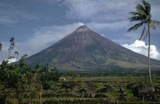
Geological Summary. Symmetrical Mayon, which rises above the Albay Gulf NW of Legazpi City, is the most active volcano of the Philippines. The steep upper slopes are capped by a small summit crater. Recorded eruptions since 1616 CE range from Strombolian to basaltic Plinian, with cyclical activity beginning with basaltic eruptions, followed by longer periods of andesitic lava flows. Eruptions occur predominately from the central conduit and have also produced lava flows that travel far down the flanks. Pyroclastic density currents and mudflows have commonly swept down many of the approximately 40 ravines that radiate from the summit and have often damaged populated lowland areas. A violent eruption in 1814 killed more than 1,200 people and devastated several towns.
Information Contacts: Philippine Institute of Volcanology and Seismology (PHIVOLCS), University of the Philippines Campus, Diliman, Quezon City, Philippines (URL: http://www.phivolcs.dost.gov.ph/); U.S. Air Force Weather Agency, Public Affairs Office; 106 Peacekeeper Dr., Ste 2NE; Offutt AFB, NE 68113-4039, USA; The Philippine Star (URL: http://www.philstar.com/).

